world.wikisort.org - United_Kingdom
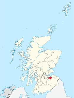
Midlothian (/mɪdˈloʊðiən/; Scottish Gaelic: Meadhan Lodainn) is a historic county, registration county, lieutenancy area and one of 32 council areas of Scotland used for local government. Midlothian lies in the east-central Lowlands, bordering the City of Edinburgh, East Lothian and the Scottish Borders.
| |
|---|---|
 | |
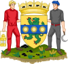 Coat of arms | |
| Coordinates: 55°53′39″N 3°04′07″W | |
| Sovereign state | |
| Country | |
| Lieutenancy area | Midlothian |
| Admin HQ | Dalkeith |
| Government | |
| • Body | Midlothian Council |
| • Control | SNP minority (council NOC) |
| • MPs |
|
| • MSPs |
|
| Area | |
| • Total | 136.6 sq mi (353.7 km2) |
| • Rank | Ranked 21st |
| Population (mid-2019 est.) | |
| • Total | 91,340 |
| • Rank | Ranked 25th |
| • Density | 670/sq mi (260/km2) |
| ONS code | S12000019 |
| ISO 3166 code | GB-MLN |
| Largest town | Penicuik |
| Website | www |
Midlothian emerged as a county in the Middle Ages under larger boundaries than the modern council area, including Edinburgh itself – and also known as Edinburghshire until 1921. It bordered West Lothian to the west, Lanarkshire, Peeblesshire and Selkirkshire to the south, and East Lothian, Berwickshire and Roxburghshire to the east. Traditional industries included mining, agriculture and fishing – although the modern council area is now landlocked.
History


Following the end of the Roman occupation of Britain, Lothian was populated by Brythonic-speaking ancient Britons and formed part of Gododdin, within the Hen Ogledd or Old North. In the seventh century, Gododdin fell to the Angles, with Lothian becoming part of the kingdom of Bernicia. Bernicia united into the Kingdom of Northumbria which itself became part of the early Kingdom of England. Lothian came under the control of the Scottish monarchy in the tenth century.
In the Middle Ages, Lothian was the scene of several historic conflicts between the kingdoms of Scotland and England. The Battle of Roslin took place in 1303 at Roslin as part of the First War of Scottish Independence. A Scottish army led by Simon Fraser and John Comyn defeated an army led by English commander John Segrave.
Along with other parts of the Lothians, the county was involved in the Rough Wooing when Roslin Castle, seat of the Earl of Caithness, was destroyed in 1544 by forces of Henry VIII of England.
In the 17th century, the county featured in the War of the Three Kingdoms, where General George Monck had his base at Dalkeith Castle as the Commonwealth's Commander in Scotland.[1] Following the Restoration of the monarchy, the "Pentland Rising" in the region culminated with the Battle of Rullion Green in 1666, a decisive victory for the Government forces against Covenanter rebels.
In 1650, Oliver Cromwell's army came to Dalkeith. His officer General George Monck, was Commander in Scotland, and the government of the country was based out of Dalkeith castle.[2]
The 1878-80 Midlothian campaign by British Liberal politician William Ewart Gladstone entered history as an early example of modern political campaigning, resulting in Gladstone taking the Midlothian constituency from the long-time Conservative Member of Parliament William Montagu Douglas Scott and going on to become Prime Minister of the United Kingdom.
The Local Government (Scotland) Act 1889 established a uniform system of county councils in Scotland and realigned the boundaries of many of Scotland's counties. Subsequently, Midlothian County Council was created in 1890. Midlothian County Council was based at Lothian Chambers in Edinburgh.[3] Under local government reforms in 1975, Midlothian became a district council within the Lothian region and in 1996 the current unitary council area was created. It contains the towns of Dalkeith, Bonnyrigg and Penicuik, as well as a portion of the Pentland Hills Regional Park, Rosslyn Chapel and Dalkeith Palace.
On 1 June 1978, Midlothian became Sister Cities with Midlothian, Illinois.
Boundaries and governance

The historic county of Midlothian remains a lieutenancy area, excluding the city of Edinburgh where lieutenancy functions are held by the Lord Provost and a registration county for which purposes Edinburgh is included.[4]
Midlothian County Council ceased to exist in 1975 under the Local Government (Scotland) Act 1973 with Midlothian becoming a district and then a unitary council area in 1996. Consequent boundary changes removed the burgh of Musselburgh and the parish of Inveresk (which included the villages of Inveresk, Wallyford and Whitecraig) to East Lothian; the Calders (East Calder, Midcalder and West Calder) and the Midlothian part of Livingston to West Lothian; Heriot and Stow parishes to the Ettrick and Lauderdale district of the Scottish Borders, and Currie, Balerno, Ratho and Newbridge to Edinburgh.
Central government
There is a Midlothian constituency of the House of Commons.
There was a Midlothian constituency of the Scottish Parliament up to the 2011 elections when it was divided between Midlothian North and Musselburgh and Midlothian South, Tweeddale and Lauderdale.
Geography

The traditional county has a roughly trapezoidal shape; it consists of a fairly flat area along the Firth of Forth, which is heavily urbanised and dominated by the Edinburgh conurbation. Off the coast lie the small islands of Inchmickery and Cramond Island. The land gradually rises to the south, with the Pentland Hills in the south-west, Moorfoot Hills in the centre-south and the Lammermuir Hills in the far south-east. Blackhope Scar on the border with Peeblesshire is the highest point in the county at 651 m (2,136 ft). The county contains no lochs of any size, though there are many reservoirs, most notably Gladhouse Reservoir, Rosebery Reservoir, Edgelaw Reservoir, Loganlea Reservoir, Glencorse Reservoir, Threipmuir Reservoir, Harlaw Reservoir, Harperrig Reservoir, Crosswood Reservoir, Morton Reservoir and Cobbinshaw Reservoir.
Settlements
Settlements within both historic and modern Midlothian
- Arniston
- Auchendinny
- Bilston
- Bonnyrigg
- Borthwick
- Carrington
- Cornbank
- Cousland
- Crichton
- Dalkeith
- Danderhall
- Deanburn
- Dewartown
- Easthouses
- Easter Howgate
- Edgehead
- Eight Mile Burn
- Eskbank
- Fala
- Ford
- Gorebridge
- Gowkshill
- Hillend
- Hopefield
- Howgate
- Lasswade
- Leadburn
- Loanhead
- Mayfield
- Millerhill
- Milton Bridge
- Newbattle
- Newtongrange
- Nine Mile Burn
- North Middleton
- Pathhead
- Penicuik
- Polton
- Rosewell
- Roslin
- Shawfair
- Silverburn
- Straiton
- Temple
- Whitehill
- Woodburn
Settlements historically in Midlothian but since transferred elsewhere
Transferred to the City of Edinburgh
This section does not cite any sources. (April 2021) |
- Abbeyhill
- Alnwickhill
- Ardmillan
- Baberton
- Balerno
- Balgreen
- Bankhead
- Barnton
- Beechmount
- Bingham
- Blackford
- Blackhall
- Bonaly
- Bonnington
- Braepark
- Broomhouse
- Broughton
- Brunstane
- Bruntsfield
- Bughtlin
- Burdiehouse
- Burghmuirhead
- The Calders
- Cameron Toll
- Cammo
- Canongate
- Canonmills
- Chesser
- Church Hill
- Clermiston
- Comely Bank
- Comiston
- Corstorphine
- Cowgate
- Craigcrook
- Craigentinny
- Craigleith
- Craiglockhart
- Craigmillar
- Craigour
- Cramond
- Crewe Toll
- Currie
- Curriehill
- Dalmahoy
- Dalry
- Davidson's Mains
- Dean Village
- Drumbrae
- Drylaw
- Duddingston
- Dumbiedykes
- East Craigs
- East Pilton
- Edinburgh
- Edinburgh Park
- Fairmilehead
- Ferniehill
- Ferry Road
- Firrhill
- Forrester
- Fountainbridge
- Gilmerton
- Gogar
- Gogarloch
- Goldenacre
- Gorgie
- Gracemount
- The Grange
- Granton
- Grassmarket
- Greenbank
- Greendykes
- Greenhill
- Haymarket
- Hermiston
- Holy Corner
- Holyrood
- Hunter's Tryst
- The Inch
- Ingliston
- Inverleith
- Jock's Lodge
- Joppa
- Juniper Green
- Kaimes
- Kingsknowe
- Lauriston
- Leith
- Liberton
- Little France
- Lochend
- Lochrin
- Longstone
- Marchmont
- Maybury
- Mayfield
- Meadowbank
- Merchiston
- Moredun
- Morningside
- Mortonhall
- Mountcastle
- Muirhouse
- Murrayfield
- Newbridge
- Newcraighall
- Newhaven
- Newington
- Niddrie
- Northfield
- Oxgangs
- Parkgrove
- Parkhead
- Piershill
- Pilrig
- Pilton
- Polworth
- Portobello
- Powderhall
- Prestonfield
- Ratho
- Ratho Station
- Ravelston
- Redford
- Restalrig
- Riccarton
- Roseburn
- Saughton
- Sciennes
- Seafield
- Shandon
- Sighthill
- Silverknowes
- Slateford
- South Gyle
- Stenhouse
- Stockbridge
- Swanston
- Tollcross
- Torphin
- Trinity
- Turnhouse
- Warriston
- West Coates
- West Craigs
- West End
- Westfield
- Wester Broom
- Wester Hailes
- Western Harbour
- West Pilton
- Willowbrae
Transferred to East Lothian
- Fisherrow
- Inveresk
- Monktonhall
- Musselburgh
- Wallyford
- Whitecraig
Transferred to Scottish Borders
- Heriot
- Stow of Wedale
Transferred to West Lothian
- Adambrae
- Addiewell
- Bellsquarry
- Breich
- Cobbinshaw
- Craigshill
- Dedridge
- East Calder
- Harburn
- Howden
- Kirknewton
- Mid Calder
- Murieston
- Polbeth
- Pumpherston
- West Calder
- Wilkieston
Places of interest
- Arniston House
- Borthwick Castle
- Castlelaw Fort
- Crichton Castle
- Dalhousie Castle
- Dalkeith Palace
- Flotterstone
- Hawthornden Castle
- Midlothian Snowsports Centre, Hillend
- National Mining Museum
- Loanhead Memorial Park
- Mavisbank House
- Melville Castle
- Newbattle Abbey
- Pentland Hills
- Roslin Castle
- Roslin Glen Country Park
- Roslin Institute
- Rosslyn Chapel
- Tyne-Esk Walk
- Vogrie Country Park
- Wallace's Cave
Civil parishes in the County of Midlothian
(Unitary authority indicated where not Midlothian. Boundaries defined by Local Government (Scotland) Act 1973)[5][6]

- Borthwick
- Carrington
- Cockpen
- Cranston
- Crichton
- Currie (Edinburgh)
- Dalkeith
- Fala and Soutra
- Glencorse
- Heriot (Scottish Borders)
- Inveresk (East Lothian)
- Kirkliston (Edinburgh)[7]
- Kirknewton (West Lothian)
- Lasswade
- Mid Calder (West Lothian)
- Newbattle
- Newton
- Penicuik
- Ratho (Edinburgh)
- Stow (Scottish Borders)
- Temple
- West Calder (West Lothian)
Former civil parishes outside Edinburgh now merged in the City of Edinburgh
Abolished 1902:[8]
Abolished 1920[9]
- Colinton
- Corstorphine
- Cramond
- Liberton
The above list does not include parishes which have been within the City of Edinburgh for county purposes since 19th century, namely within the "County of the City" of which the Lord Provost was and is Lord Lieutenant.[10]
Transport
Midlothian has a modern road network as well as some rural single-track roads. The Borders Railway runs between Tweedbank to Edinburgh, with four stations in Midlothian – Shawfair, Eskbank, Newtongrange and Gorebridge.
Notable people associated with Midlothian
- William Drummond of Hawthornden (1585–1649), Scottish poet.
- Princess Margaret of Scotland (1598–1600), daughter of James VI and I of Scotland and England (born Dalkeith Palace)
- John Clerk of Penicuik, 2nd Baronet (1676–1755), was a Scottish politician, lawyer, judge, composer and architect.
- William Robertson (1721–1793), historian, minister in the Church of Scotland, and Principal of the University of Edinburgh
- Robert Smith (1722–1777), American architect, based in Philadelphia, Pennsylvania, born in Dalkeith
- Hector Macneill (1746–1818), poet and songwriter, born near Roslin
- John Clerk, Lord Eldin (1757–1832), Scottish judge, lived in Lasswade for several years.
- Sir Walter Scott (1771–1832) wrote the novel The Heart of Midlothian and lived at Lasswade Cottage (now Sir Walter Scott's Cottage) in Lasswade from 1798 to 1804, where he wrote his Grey Brother, translation of Goetz von Berlichingen, etc. and was visited by Wordsworth.
- William Tennant (1784–1848), the author of Anster Fair, was parish schoolmaster in Lasswade from 1816 to 1819.
- Thomas de Quincey (1785–1859), author of Confessions of an English Opium-Eater (1822), lived in Man's Bush Cottage (now De Quincey Cottage), Polton, from 1840 until his death in 1859.
- Thomas Murray (1792–1872), the Gallovidian author, died in Lasswade.
- William Ewart Gladstone (1809–1898), MP for Midlothian 1880–1895 and conducted his famous Midlothian campaign across the UK in 1880
- Patrick Edward Dove (1815–1873), mainly remembered for his book The Theory of Human Progression, born at Lasswade
- John Lawson Johnston (1839–1900), the creator of Bovril, born at Roslin.
- Charles W. Nibley (1849–1931), Scottish-American religious leader in The Church of Jesus Christ of Latter-day Saints (LDS Church). Nibley was served as second counselor in the First Presidency to Heber J. Grant (1925–31), and Presiding Bishop (1907–25).
- Charles Thomson Rees Wilson (1869–1959) of Glencorse, Nobel prize-winning physicist.
- George Forrest (1873–1932), a plant collector who gained fame with his expeditions to the far east who spent a significant part of his early years in Loanhead.
- Sir William MacTaggart (1903–1981), artist, and grandson of the artist William McTaggart, he became President of the Society of Scottish Artists, President of the Royal Scottish Academy, and Trustee of the National Museum of Antiquities.
- Charles Forte, Baron Forte (1908–2007), the hotelier, worked in an Italian cafe in Loanhead, on his arrival in Scotland from Italy.
- Karl Miller (1931–2014), founding editor of the London Review of Books and Lord Northcliffe Professor of Modern English Literature at University College, London (1974–1992), born in Straiton.
- Annette Crosbie (born 1934), actress, born in Gorebridge
- Ishbel MacAskill (1941–2011), heritage activist and traditional Scottish Gaelic singer and teacher
- Gary Naysmith from Loanhead (born 1978), Scottish International Footballer who played for Heart of Midlothian and Everton. He was named Scottish PFA Young Player of the Year in 1998. He won the Scottish Cup with Hearts in 1998.
- Darren Fletcher (born 1984), from Mayfield Dalkeith. Scotland International footballer and holds the record of being the youngest player to captain his national side, and was part of the Manchester United squad that won the UEFA Champions League in the 2007–2008 season.
- Steven Whittaker from Bonnyrigg, (born 1984), Scotland International footballer, ex-Hibernian F.C. and Rangers F.C.
Schools in Midlothian
Primary schools
- Bilston Primary School, Bilston
- Bonnyrigg Primary School, Bonnyrigg
- Burnbrae Primary School, Hopefield
- Cornbank St James Primary School, Penicuik
- Cuiken Primary School, Penicuik
- Danderhall Primary School, Danderhall
- Gore Glen Primary School, Gorebridge
- Gorebridge Primary School, Gorebridge
- Hawthornden Primary School, Bonnyrigg
- King's Park Primary School, Dalkeith
- Lasswade Primary School, Lasswade
- Lawfield Primary School, Mayfield
- Loanhead Primary School, Loanhead
- Mauricewood Primary School, Penicuik
- Mayfield Primary School, Mayfield
- Moorfoot Primary School, North Middleton
- Newtongrange Primary School, Newtongrange
- Paradykes Primary School, Loanhead
- Rosewell Primary School, Rosewell
- Roslin Primary School, Roslin
- Sacred Heart RC Primary School, Penicuik
- St Andrews's RC Primary School Gorebridge
- St David's RC Primary School Dalkeith
- St Luke's RC Primary School, Mayfield
- St Margaret's RC Primary School, Loanhead
- St Mary's RC Primary School, Bonnyrigg
- St Matthew's RC Primary School, Rosewell
- Stobhill Primary School, Gorebridge
- Strathesk Primary School, Penicuik
- Tynewater Primary School, Pathhead
- Woodburn Primary School, Woodburn
Secondary schools
- Beeslack High School, Penicuik
- Dalkeith High School, Dalkeith
- Lasswade High School Centre, Bonnyrigg
- Newbattle Community High School, Dalkeith
- Penicuik High School, Penicuik
- St. David's RC High School, Dalkeith
Special schools
Twin towns and sister cities
Midlothian is twinned with Komárom-Esztergom, Hungary and Kreis Heinsberg, Germany. It is a sister city with Midlothian, Illinois, a suburb of Chicago a town of Illinois.[11]
References
- "The History of Dalkeith House and Estate" (PDF). Archived from the original (PDF) on 24 January 2016. Retrieved 13 December 2011.
- "The History of Dalkeith House and Estate" (PDF). Archived from the original (PDF) on 24 January 2016. Retrieved 13 December 2011.
- Historic Environment Scotland. "59-63 George IV Bridge, Lothian Chambers, including boundary balustrade (LB27674)". Retrieved 18 July 2021.
- "Land Mass Coverage Report" (PDF). Registers of Scotland. Archived from the original (PDF) on 3 March 2016. Retrieved 16 May 2015.
- List from Contents page of the Statistical Account of Edinburghshire, published by William Blackwood and Sons, Edinburgh, 1845, including only those parishes appearing in the 2011 Census
- Census of Scotland 2011, Table KS101SC – Usually Resident Population, published by National Records of Scotland. Website http://www.scotlandscensus.gov.uk/ retrieved March 2016. See "Standard Outputs", Table KS101SC, Area type: Civil Parish 1930
- Partly in West Lothian. Article on Kirkliston in Ordnance Gazetteer of Scotland, by, Francis Groome, 2nd Edition, 1896
- Order of the Secretary State for Scotland, effective from 15 May 1902, publ. in Edinburgh Gazette 1 April 1902, p. 350
- Edinburgh Boundaries Extension and Tramways Act 1920
- The Statistical Account of Edinburghshire, publ by William Blackwood and Sons, Edinburgh, 1845;p.648
- "Illinois Member List updated June 2015 »". www.illinoissistercities.org. Retrieved 29 March 2018.
External links
 Media related to Midlothian at Wikimedia Commons
- Midlothian at Curlie
Local government areas of Scotland, in use 1973 to 1996 | ||
|---|---|---|
| Borders |
|  |
| Central Region | ||
| Dumfries and Galloway |
| |
| Fife |
| |
| Grampian |
| |
| Highland |
| |
| Lothian |
| |
| Strathclyde |
| |
| Tayside |
| |
| Island areas1 |
| |
1 The island areas were unitary authorities, combining the powers of a region and a district. | ||
Authority control | |
|---|---|
| General | |
| National libraries | |
| Other |
|
На других языках
- [en] Midlothian
[ru] Мидлотиан
Мидло́тиан (англ. Midlothian, гэльск. Meadhan Lodainn) — один из 32 округов Шотландии. Граничит с городом Эдинбург на западе и областями Ист-Лотиан на востоке и Скоттиш-Бордерс на юге. До 1921 г. носил официальное название графство Эдинбург[1].Другой контент может иметь иную лицензию. Перед использованием материалов сайта WikiSort.org внимательно изучите правила лицензирования конкретных элементов наполнения сайта.
WikiSort.org - проект по пересортировке и дополнению контента Википедии