world.wikisort.org - United_Kingdom
Cockley Cley is a village and civil parish in the English county of Norfolk. It covers an area of 17.94 km2 (6.93 sq mi) and had a population of 138 in 58 households in the 2001 census,[2] including South Pickenham, and increasing to a population of 232 in 103 households at the 2011 Census. For the purposes of local government, it falls within the district of Breckland.
| Cockley Cley | |
|---|---|
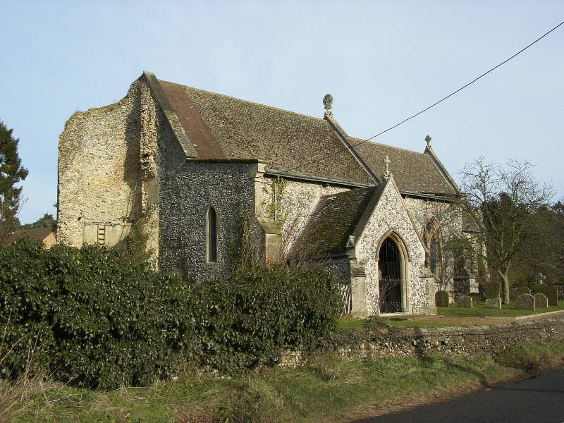 Cockley Cley All Saints, minus tower (remnants at left) | |
 Cockley Cley Location within Norfolk | |
| Area | 17.94 km2 (6.93 sq mi) |
| Population | 232 (2011) [1] |
| • Density | 13/km2 (34/sq mi) |
| OS grid reference | TF792042 |
| Civil parish |
|
| District |
|
| Shire county |
|
| Region | |
| Country | England |
| Sovereign state | United Kingdom |
| Post town | SWAFFHAM |
| Postcode district | PE37 |
| Police | Norfolk |
| Fire | Norfolk |
| Ambulance | East of England |
The first part of the village's name is of uncertain etymology. It may mean 'wood frequented by woodcocks', or it may be a local family name. Cley simply means "clay, place with clayey soil".[3]
Its church, All Saints, is one of 124 existing round-tower churches in Norfolk but in 1991 much of the tower collapsed. The church was restored in 1866–88 by diocesan architect Richard Phipson.[4] The interior was not harmed by the tower's collapse and exhibits the Victorian concept of how a church should look. The north arcade is 14th century, and it has been copied for the south arcade.[5]
From 1975 a reconstructed Iceni village was a visitor attraction at Cockley Cley. It finally closed in 2014.[6]
Gallery
 Cockley Cley village sign, showing the church still with its tower
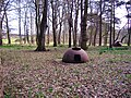 Rare Allan Williams Turret fortifications of World War II in Cockley Cley
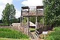 Entrance to the reconstruction of an Iceni village, now closed


See also
- The Norfolk headless body – a woman, believed murdered, whose decapitated body was found here in 1974. Her DNA suggested she might have been Danish, but her identity was never discovered.
References
- "Civil Parish population 2011". Neighbourhood Statistics. Office for National Statistics. Retrieved 1 August 2016.
- Census population and household counts for unparished urban areas and all parishes. Office for National Statistics & Norfolk County Council (2001). Retrieved 20 June 2009.
- Mills, A. D. (1996) [1991]. A Dictionary of English Place Names. Oxford: Oxford University Press. p. 85. ISBN 0192831313. Retrieved 3 April 2022.
- Wilson, Bill (2002). Norfolk, Part 2. Yale UP. p. 265. ISBN 978-0-300-09657-6.
- The Round Tower Churches of Norfolk by Lyn Stilgoe and Dorothy Shreeve, Canterbury Press, Norwich; ISBN 1-85311-448-0
- "Cockley Cley auction brings end to heritage site’s saga" EDP 16 October 2014
http://kepn.nottingham.ac.uk/map/place/Norfolk/Cockley%20Clay
External links
Authority control | |
|---|---|
| General |
|
| National libraries | |
This Norfolk location article is a stub. You can help Wikipedia by expanding it. |
Другой контент может иметь иную лицензию. Перед использованием материалов сайта WikiSort.org внимательно изучите правила лицензирования конкретных элементов наполнения сайта.
WikiSort.org - проект по пересортировке и дополнению контента Википедии