world.wikisort.org - Turkey
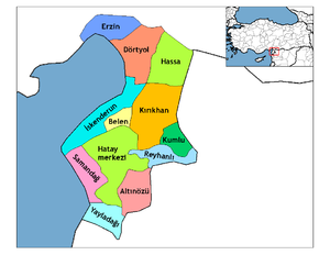
Yayladağı (pronounced [ˈjajɫaˈdaɯ], Arabic: اوردو, romanized: ʾŪrdū, Western Armenian: Օրտու, romanized: Ōrdu) is a town and district of Hatay Province in southern Turkey, on the border between Turkey and Syria, 51 km (32 mi) south of the city of Antakya.
Yayladağı | |
|---|---|
 | |
 Yayladağı | |
| Coordinates: 35°54′09″N 36°03′38″E | |
| Country | Turkey |
| Province | Hatay |
| Government | |
| • Mayor | Mustafa Kemal Dağıstanlı (MHP) |
| • Kaymakam | Tolga Polat |
| Area | |
| • District | 340.81 km2 (131.59 sq mi) |
| Elevation | 450 m (1,480 ft) |
| Population (2012)[2] | |
| • Urban | 6,814 |
| • District | 21,766 |
| • District density | 64/km2 (170/sq mi) |
| Post code | 31550 |
| Website | www.yayladagi.bel.tr |
History
This section does not cite any sources. (March 2020) |
The district has a long history dating back to the Hittites. Islam was brought here by the Abbasid Arabs, and from 1075 onwards the Seljuk Turks. During the Crusades, the mountains were part of the principality of Antioch, then they returned to Muslim control, and in 1518 were brought into the Ottoman Empire by Sultan Selim I during his campaign into Egypt.
Demographics
It is estimated that the population of Yayladağı is mostly composed of Sunni Turkmen. After the Syrian Civil War broke out, nearly 2,000 Syrian Turkmen moved here from Turkmen Mountain.[3]
Geography
This section does not cite any sources. (March 2020) |
Today, Yayladağı itself is a small town of 5,717 people as of 2000 census, providing the district with a health centre, high schools and other basics.
This is a mountainous district with a typical Mediterranean climate of hot, dry summers and warm, wet winters, but being inland and high up, Yayladağı is cooler than most of Hatay, even seeing snow on the mountain peaks in winter. The main source of income is agriculture, 96 km2 (37 sq mi) of the land (small valleys and plateau in the mountains) is cultivated with olives, tobacco, vegetables, grains and other crops, the remainder is forest and mountain. The mountainsides are covered with pine, sandalwood and rough oak, or else shrubs including bay, thyme and oleander. Animals, especially goats, are grazed on the hillsides.
Yayladağı has a border crossing into Syria, and the village of Topraktutan, Turkey's southernmost point. The state road ![]() D.825 (European route
D.825 (European route ![]() E91) connects the border checkpoint with Antakya.
E91) connects the border checkpoint with Antakya.
Places of interest
- Kasım Bey Cami - Yayladağı's oldest mosque, built by the Avar lord that captured the area from the Byzantines. Other historical buildings include the 500-year-old mosque Hacı Hüseyin Camii, and a Roman bridge. There are ancient churches including the Monastery of Saint Barlaam on the Kel Dağı mountain, others in the villages of Çabala and Olgunlar, and the monastery named Kızlar Sarayı. There are also a number of caves and places said to possess healing powers.[citation needed]
References
- "Area of regions (including lakes), km²". Regional Statistics Database. Turkish Statistical Institute. 2002. Retrieved 2013-03-05.
- "Population of province/district centers and towns/villages by districts - 2012". Address Based Population Registration System (ABPRS) Database. Turkish Statistical Institute. Retrieved 2013-02-27.
- Bayırbucak Türkmenleri Yayladağı'ndaki kampa alınıyor
External links
- District governorate's official website (in Turkish)
Yayladağı in Hatay Province of Turkey | |||||||||||||||||||||||||||
|---|---|---|---|---|---|---|---|---|---|---|---|---|---|---|---|---|---|---|---|---|---|---|---|---|---|---|---|
| Districts |   | ||||||||||||||||||||||||||
|
Metropolitan municipalities are bolded. | |||||||||||||||||||||||||||
| Bulgaria |
|
|---|---|
| Greece | |
| Syria | |
| Iraq | |
| Iran | |
| Nakhchivan (Azerbaijan) | |
| Armenia | |
| Georgia | |
Authority control | |
|---|---|
| General |
|
| National libraries | |
This article about a Mediterranean Region of Turkey location is a stub. You can help Wikipedia by expanding it. |
На других языках
[de] Yayladağı
Yayladağı (früher Ordu) ist eine Stadtgemeinde (Belediye) im gleichnamigen Ilçe (Landkreis) der Provinz Hatay in der türkischen Mittelmeerregion und gleichzeitig ein Stadtbezirk der 2012 gebildeten Büyükşehir belediyesi Hatay (Großstadtgemeinde/Metropolprovinz). Yayladağı ist seit der Gebietsreform ab 2013 flächen- und einwohnermäßig identisch mit dem Landkreis. Die im Stadtlogo manifestierte Jahreszahl (1936) dürfte ein Hinweis auf das Jahr der Erhebung zur Stadtgemeinde (Belediye) sein.- [en] Yayladağı
[ru] Яйладагы
Яйладагы (тур. Yayladağı) — город и район в провинции Хатай (Турция).Другой контент может иметь иную лицензию. Перед использованием материалов сайта WikiSort.org внимательно изучите правила лицензирования конкретных элементов наполнения сайта.
WikiSort.org - проект по пересортировке и дополнению контента Википедии