world.wikisort.org - Philippines
Sapa-Sapa, officially the Municipality of Sapa-Sapa, is a 3rd class municipality in the province of Tawi-Tawi, Philippines. According to the 2020 census, it has a population of 33,580. [3]
Sapa-Sapa
ساڤ-ساڤ | |
|---|---|
Municipality | |
| Municipality of Sapa-Sapa | |
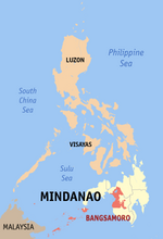
 Map of Tawi-Tawi with Sapa-Sapa highlighted | |
OpenStreetMap  | |
 Sapa-Sapa Location within the Philippines | |
| Coordinates: 5°05′24″N 120°16′22″E | |
| Country | Philippines |
| Region | Bangsamoro Autonomous Region in Muslim Mindanao |
| Province | Tawi-Tawi |
| District | Lone district |
| Barangays | 23 (see Barangays) |
| Government | |
| • Type | Sangguniang Bayan |
| • Mayor | Rhodesia M. Sali |
| • Vice Mayor | Karim Darwis J. Masdal |
| • Representative | Dimszar M. Sali |
| • Municipal Council | Members |
| • Electorate | 18,419 voters (2022) |
| Area | |
| • Total | 235.61 km2 (90.97 sq mi) |
| Elevation | 5.0 m (16.4 ft) |
| Highest elevation | 529 m (1,736 ft) |
| Lowest elevation | 0 m (0 ft) |
| Population | |
| • Total | 33,580 |
| • Density | 140/km2 (370/sq mi) |
| • Households | 5,548 |
| Economy | |
| • Income class | 3rd municipal income class |
| • Poverty incidence | 24.76% (2018)[4] |
| • Revenue | ₱149,071,063.40 (2020) |
| • Assets | ₱124,973,642.03 (2020) |
| • Expenditure | ₱139,066,908.87 (2020) |
| • Liabilities | ₱4,929,058.74 (2020) |
| Service provider | |
| • Electricity | Tawi Tawi Electric Cooperative (TAWELCO) |
| Time zone | UTC+8 (PST) |
| ZIP code | 7503 |
| PSGC | |
| IDD : area code | +63 (0)68 |
| Native languages | Sama Tagalog |
| Website | www |
Geography
Barangays
Sapa-sapa is politically subdivided into 23 barangays.
- Baldatal
- Butun
- Dalo-Dalo
- Kohek
- Lakit-Lakit
- Latuan (Sunsang)
- Banaran Lookan
- Look Natoh
- Lookan Latuan
- Malanta
- Tambunan
- Sikubong
- Palatih Gadjaminah
- Pamasan
- Sapaat
- Sapa-Sapa (Poblacion)
- Sokah-sokah
- Bukut Sikubong
- Tangngah Deom Sikubong
- Tapian Bohe North
- Tapian Bohe South
- Banaran Tunggusong
- Mantabuan Sannang Hati
- Lookan Tup-Tup
Panampangan Island
Panampangan Island is located in the municipality of Sapa-sapa. The island itself is famous for its sandbar which is considered[by whom?] the longest in the Philippines.[citation needed]
At low tide, the sandbar connects to the nearby islet of Panampangan island.
Climate
| Climate data for Sapa-Sapa, Tawi-Tawi | |||||||||||||
|---|---|---|---|---|---|---|---|---|---|---|---|---|---|
| Month | Jan | Feb | Mar | Apr | May | Jun | Jul | Aug | Sep | Oct | Nov | Dec | Year |
| Average high °C (°F) | 29 (84) |
29 (84) |
29 (84) |
30 (86) |
30 (86) |
30 (86) |
29 (84) |
30 (86) |
30 (86) |
30 (86) |
29 (84) |
29 (84) |
30 (85) |
| Average low °C (°F) | 25 (77) |
24 (75) |
24 (75) |
25 (77) |
25 (77) |
25 (77) |
25 (77) |
25 (77) |
25 (77) |
25 (77) |
25 (77) |
25 (77) |
25 (77) |
| Average precipitation mm (inches) | 157 (6.2) |
115 (4.5) |
123 (4.8) |
96 (3.8) |
136 (5.4) |
120 (4.7) |
104 (4.1) |
89 (3.5) |
86 (3.4) |
131 (5.2) |
151 (5.9) |
159 (6.3) |
1,467 (57.8) |
| Average rainy days | 20.4 | 17.5 | 20.4 | 21.1 | 26.7 | 25.7 | 26.0 | 24.5 | 24.0 | 27.7 | 26.3 | 24.7 | 285 |
| Source: Meteoblue[5] | |||||||||||||
Demographics
| Year | Pop. | ±% p.a. |
|---|---|---|
| 1980 | 14,946 | — |
| 1990 | 16,173 | +0.79% |
| 1995 | 17,728 | +1.73% |
| 2000 | 26,242 | +8.77% |
| 2007 | 37,135 | +4.91% |
| 2010 | 28,781 | −8.86% |
| 2015 | 30,917 | +1.37% |
| 2020 | 33,580 | +1.64% |
| Source: Philippine Statistics Authority [6] [7] [8][9] | ||
Economy
References
- Municipality of Sapa-Sapa | (DILG)
- "2015 Census of Population, Report No. 3 – Population, Land Area, and Population Density" (PDF). Philippine Statistics Authority. Quezon City, Philippines. August 2016. ISSN 0117-1453. Archived (PDF) from the original on May 25, 2021. Retrieved July 16, 2021.
- Census of Population (2020). "BARMM". Total Population by Province, City, Municipality and Barangay. PSA. Retrieved 8 July 2021.
- "PSA Releases the 2018 Municipal and City Level Poverty Estimates". Philippine Statistics Authority. 15 December 2021. Retrieved 22 January 2022.
- "Sapa-Sapa, Tawi-Tawi : Average Temperatures and Rainfall". Meteoblue. Retrieved 30 January 2019.
- Census of Population (2015). "ARMM – Autonomous Region in Muslim Mindanao". Total Population by Province, City, Municipality and Barangay. PSA. Retrieved 20 June 2016.
- Census of Population and Housing (2010). "ARMM – Autonomous Region in Muslim Mindanao". Total Population by Province, City, Municipality and Barangay. NSO. Retrieved 29 June 2016.
- Censuses of Population (1903–2007). "ARMM – Autonomous Region in Muslim Mindanao". Table 1. Population Enumerated in Various Censuses by Province/Highly Urbanized City: 1903 to 2007. NSO.
- "Province of Tawi‑tawi". Municipality Population Data. Local Water Utilities Administration Research Division. Retrieved 17 December 2016.
- "Poverty incidence (PI):". Philippine Statistics Authority. Retrieved 28 December 2020.
- https://psa.gov.ph/sites/default/files/NSCB_LocalPovertyPhilippines_0.pdf; publication date: 29 November 2005; publisher: Philippine Statistics Authority.
- https://psa.gov.ph/sites/default/files/2003%20SAE%20of%20poverty%20%28Full%20Report%29_1.pdf; publication date: 23 March 2009; publisher: Philippine Statistics Authority.
- https://psa.gov.ph/sites/default/files/2006%20and%202009%20City%20and%20Municipal%20Level%20Poverty%20Estimates_0_1.pdf; publication date: 3 August 2012; publisher: Philippine Statistics Authority.
- https://psa.gov.ph/sites/default/files/2012%20Municipal%20and%20City%20Level%20Poverty%20Estima7tes%20Publication%20%281%29.pdf; publication date: 31 May 2016; publisher: Philippine Statistics Authority.
- https://psa.gov.ph/sites/default/files/City%20and%20Municipal-level%20Small%20Area%20Poverty%20Estimates_%202009%2C%202012%20and%202015_0.xlsx; publication date: 10 July 2019; publisher: Philippine Statistics Authority.
- "PSA Releases the 2018 Municipal and City Level Poverty Estimates". Philippine Statistics Authority. 15 December 2021. Retrieved 22 January 2022.
External links
- Sapa-Sapa Profile at PhilAtlas.com
- Philippine Standard Geographic Code
- Sapa-Sapa Profile at the DTI Cities and Municipalities Competitive Index
- Philippine Census Information
Places adjacent to Sapa-Sapa | ||||||||||||||||
|---|---|---|---|---|---|---|---|---|---|---|---|---|---|---|---|---|
| ||||||||||||||||
This article about a location in the Bangsamoro Autonomous Region in Muslim Mindanao is a stub. You can help Wikipedia by expanding it. |
На других языках
[de] Sapa-Sapa
Sapa-Sapa ist eine philippinische Stadtgemeinde in der Provinz Tawi-Tawi. Sie hat 30.917 Einwohner (Zensus 1. August 2015).- [en] Sapa-Sapa
Текст в блоке "Читать" взят с сайта "Википедия" и доступен по лицензии Creative Commons Attribution-ShareAlike; в отдельных случаях могут действовать дополнительные условия.
Другой контент может иметь иную лицензию. Перед использованием материалов сайта WikiSort.org внимательно изучите правила лицензирования конкретных элементов наполнения сайта.
Другой контент может иметь иную лицензию. Перед использованием материалов сайта WikiSort.org внимательно изучите правила лицензирования конкретных элементов наполнения сайта.
2019-2026
WikiSort.org - проект по пересортировке и дополнению контента Википедии
WikiSort.org - проект по пересортировке и дополнению контента Википедии