world.wikisort.org - Philippines
Matanog, officially the Municipality of Matanog, is a 4th class municipality in the province of Maguindanao del Norte, Philippines. According to the 2020 census, it has a population of 36,034 people. [3]
Matanog | |
|---|---|
Municipality | |
| Municipality of Matanog | |
 Poblacion of Matanog | |
 Seal | |
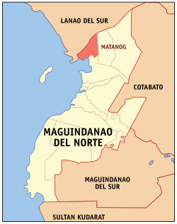 Map of Maguindanao del Norte with Matanog highlighted | |
OpenStreetMap  | |
 Matanog Location within the Philippines | |
| Coordinates: 7°28′N 124°15′E | |
| Country | Philippines |
| Region | Bangsamoro Autonomous Region in Muslim Mindanao |
| Province | Maguindanao del Norte |
| District | Lone district |
| Founded | August 25, 1975 |
| Barangays | 8 (see Barangays) |
| Government | |
| • Type | Sangguniang Bayan |
| • Mayor | Zohria S. Bansil-Guro |
| • Vice Mayor | Sanaira I. Ali |
| • Representative | Sittie Shahara "Dimple" I. Mastura |
| • Municipal Council | Members |
| • Electorate | 19,592 voters (2022) |
| Area | |
| • Total | 146.50 km2 (56.56 sq mi) |
| Elevation | 328 m (1,076 ft) |
| Highest elevation | 1,064 m (3,491 ft) |
| Lowest elevation | 7 m (23 ft) |
| Population | |
| • Total | 36,034 |
| • Density | 250/km2 (640/sq mi) |
| • Households | 5,711 |
| Economy | |
| • Income class | 4th municipal income class |
| • Poverty incidence | 64.66% (2018)[4] |
| • Revenue | ₱132,307,000.00 (2020) |
| • Assets | ₱441,871,000.00 (2020) |
| • Expenditure | ₱105,387,000.00 (2020) |
| • Liabilities | ₱353,521,000.00 (2020) |
| Service provider | |
| • Electricity | Maguindanao Electric Cooperative (MAGELCO) |
| Time zone | UTC+8 (PST) |
| ZIP code | 9613 |
| PSGC | |
| IDD : area code | +63 (0)64 |
| Native languages | Maguindanao Maranao Tagalog |
| Website | www |
Matanog was created by virtue of Presidential Decree No. 780 signed by then President Ferdinand Marcos on August 25, 1975.[5] It was carved from the municipality of Parang.
The town was part of the province of Shariff Kabunsuan from October 2006 until its nullification by the Supreme Court in July 2008.
Geography
Barangays

Matanog is politically subdivided into 8 barangays.
- Bayanga Norte
- Bayanga Sur
- Bugasan Norte
- Bugasan Sur (Poblacion)
- Kidama
- Sapad
- Langco
- Langkong
Climate
| Climate data for Matanog, Maguindanao | |||||||||||||
|---|---|---|---|---|---|---|---|---|---|---|---|---|---|
| Month | Jan | Feb | Mar | Apr | May | Jun | Jul | Aug | Sep | Oct | Nov | Dec | Year |
| Average high °C (°F) | 28 (82) |
28 (82) |
28 (82) |
29 (84) |
28 (82) |
27 (81) |
27 (81) |
27 (81) |
27 (81) |
27 (81) |
27 (81) |
28 (82) |
28 (82) |
| Average low °C (°F) | 22 (72) |
22 (72) |
22 (72) |
23 (73) |
23 (73) |
23 (73) |
22 (72) |
22 (72) |
22 (72) |
22 (72) |
23 (73) |
22 (72) |
22 (72) |
| Average precipitation mm (inches) | 236 (9.3) |
225 (8.9) |
244 (9.6) |
235 (9.3) |
304 (12.0) |
287 (11.3) |
200 (7.9) |
175 (6.9) |
158 (6.2) |
200 (7.9) |
287 (11.3) |
243 (9.6) |
2,794 (110.2) |
| Average rainy days | 24.3 | 22.3 | 26.0 | 27.2 | 28.3 | 27.2 | 25.8 | 24.8 | 22.2 | 25.4 | 27.2 | 25.8 | 306.5 |
| Source: Meteoblue (modeled/calculated data, not measured locally)[6] | |||||||||||||
Demographics
| Year | Pop. | ±% p.a. |
|---|---|---|
| 1980 | 8,300 | — |
| 1990 | 14,759 | +5.93% |
| 1995 | 16,018 | +1.55% |
| 2000 | 19,006 | +3.73% |
| 2007 | 36,319 | +9.34% |
| 2010 | 23,269 | −14.96% |
| 2015 | 29,770 | +4.80% |
| 2020 | 36,034 | +3.83% |
| Source: Philippine Statistics Authority [7] [8] [9] | ||
Economy
References
- Municipality of Matanog | (DILG)
- "2015 Census of Population, Report No. 3 – Population, Land Area, and Population Density" (PDF). Philippine Statistics Authority. Quezon City, Philippines. August 2016. ISSN 0117-1453. Archived (PDF) from the original on May 25, 2021. Retrieved July 16, 2021.
- Census of Population (2020). "BARMM". Total Population by Province, City, Municipality and Barangay. PSA. Retrieved 8 July 2021.
- "PSA Releases the 2018 Municipal and City Level Poverty Estimates". Philippine Statistics Authority. 15 December 2021. Retrieved 22 January 2022.
- "Presidential Decree No. 780, s. 1975 | GOVPH".
- "Matanog, Maguindanao : Average Temperatures and Rainfall". Meteoblue. Retrieved 19 January 2019.
- Census of Population (2015). "ARMM – Autonomous Region in Muslim Mindanao". Total Population by Province, City, Municipality and Barangay. PSA. Retrieved 20 June 2016.
- Census of Population and Housing (2010). "ARMM – Autonomous Region in Muslim Mindanao". Total Population by Province, City, Municipality and Barangay. NSO. Retrieved 29 June 2016.
- Censuses of Population (1903–2007). "ARMM – Autonomous Region in Muslim Mindanao". Table 1. Population Enumerated in Various Censuses by Province/Highly Urbanized City: 1903 to 2007. NSO.
- "Poverty incidence (PI):". Philippine Statistics Authority. Retrieved 28 December 2020.
- https://psa.gov.ph/sites/default/files/NSCB_LocalPovertyPhilippines_0.pdf; publication date: 29 November 2005; publisher: Philippine Statistics Authority.
- https://psa.gov.ph/sites/default/files/2003%20SAE%20of%20poverty%20%28Full%20Report%29_1.pdf; publication date: 23 March 2009; publisher: Philippine Statistics Authority.
- https://psa.gov.ph/sites/default/files/2006%20and%202009%20City%20and%20Municipal%20Level%20Poverty%20Estimates_0_1.pdf; publication date: 3 August 2012; publisher: Philippine Statistics Authority.
- https://psa.gov.ph/sites/default/files/2012%20Municipal%20and%20City%20Level%20Poverty%20Estima7tes%20Publication%20%281%29.pdf; publication date: 31 May 2016; publisher: Philippine Statistics Authority.
- https://psa.gov.ph/sites/default/files/City%20and%20Municipal-level%20Small%20Area%20Poverty%20Estimates_%202009%2C%202012%20and%202015_0.xlsx; publication date: 10 July 2019; publisher: Philippine Statistics Authority.
- "PSA Releases the 2018 Municipal and City Level Poverty Estimates". Philippine Statistics Authority. 15 December 2021. Retrieved 22 January 2022.
External links
- Philippine Standard Geographic Code
- Matanog Profile at the DTI Cities and Municipalities Competitive Index
- Philippine Census Information
- Local Governance Performance Management System
Places adjacent to Matanog | ||||||||||||||||
|---|---|---|---|---|---|---|---|---|---|---|---|---|---|---|---|---|
| ||||||||||||||||
This article about a location in the Bangsamoro Autonomous Region in Muslim Mindanao is a stub. You can help Wikipedia by expanding it. |
На других языках
[de] Matanog
Matanog ist eine philippinische Stadtgemeinde in der Provinz Shariff Kabunsuan. Sie hat 29.770 Einwohner (Zensus 1. August 2015).- [en] Matanog
Текст в блоке "Читать" взят с сайта "Википедия" и доступен по лицензии Creative Commons Attribution-ShareAlike; в отдельных случаях могут действовать дополнительные условия.
Другой контент может иметь иную лицензию. Перед использованием материалов сайта WikiSort.org внимательно изучите правила лицензирования конкретных элементов наполнения сайта.
Другой контент может иметь иную лицензию. Перед использованием материалов сайта WikiSort.org внимательно изучите правила лицензирования конкретных элементов наполнения сайта.
2019-2026
WikiSort.org - проект по пересортировке и дополнению контента Википедии
WikiSort.org - проект по пересортировке и дополнению контента Википедии