world.wikisort.org - Philippines
Quirino (Ilocano: Probinsia ti Quirino; Tagalog: Lalawigan ng Quirino), is a landlocked province in the Philippines located in the Cagayan Valley region in Luzon. Its capital is Cabarroguis. It is named after Elpidio Quirino, the sixth President of the Philippines.
Quirino | |
|---|---|
Province | |
| Province of Quirino | |
 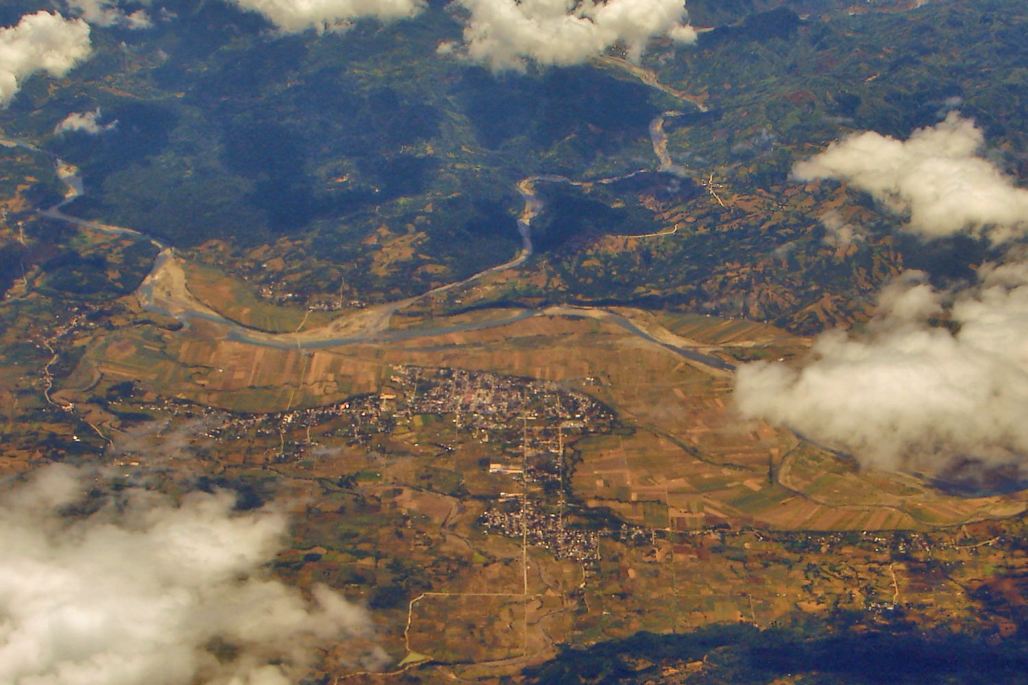   (from top: left to right) Quirino Provincial Capitol, Aerial view of Maddela, Diffun town and Cabarroguis Town Hall. | |
 Flag  Seal | |
| Nickname: Forest Heartland of Cagayan Valley | |
 Location within the Philippines | |
OpenStreetMap  | |
| Coordinates: 16°17′N 121°35′E | |
| Country | Philippines |
| Region | Cagayan Valley |
| Founded | June 18, 1966 |
| Named for | Elpidio Quirino |
| Capital | Cabarroguis |
| Largest Municipality | Diffun |
| Government | |
| • Type | Sangguniang Panlalawigan |
| • Governor | Dakila Carlo E. Cua (PDP-Laban) |
| • Vice Governor | Julius Caesar S. Vaquilar (PDP-Laban) |
| • Representative | Junie E. Cua (PDP-Laban) |
| • Legislature | Quirino Provincial Board |
| Area | |
| • Total | 3,323.47 km2 (1,283.20 sq mi) |
| • Rank | 54th out of 81 |
| Highest elevation (Mount Dialanese) | 1,808 m (5,932 ft) |
| Population | |
| • Total | 203,828 |
| • Rank | 73rd out of 81 |
| • Density | 61/km2 (160/sq mi) |
| • Rank | 72nd out of 81 |
| Divisions | |
| • Independent cities | 0 |
| • Component cities | 0 |
| • Municipalities | 6
|
| • Barangays | 132 |
| • Districts | Legislative district of Quirino |
| Time zone | UTC+8 (PHT) |
| ZIP code | 3400–3405 |
| IDD : area code | +63 (0)78 |
| ISO 3166 code | PH-QUI |
| Spoken languages |
|
| Website | www |
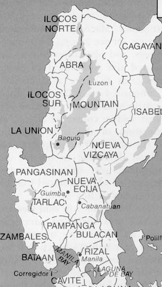
The province borders Aurora to the southeast, Nueva Vizcaya to the west, and Isabela to the north. Quirino used to be part of the province of Nueva Vizcaya, until it was separated in 1966.
History
Long before its formal creation as an independent province, Quirino was the forest region of the province of Nueva Vizcaya, inhabited by tribal groups known as the Negritos. They roamed the hinterlands and built their huts at the heart of the jungle.
On June 18, 1966, Republic Act 4734 was enacted, constituting the municipalities of Diffun, Saguday, Aglipay, and Maddela (all of Nueva Vizcaya province) into a new sub-province to be known as "Quirino", named after the late Philippine president Elpidio Quirino.[3][4]
On June 21, 1969, Republic Act 5554 was enacted, amending RA 4734 and creating the municipality of Cabarroguis (now the provincial capital town), which was taken from portions of Diffun, Saguday, and Aglipay.[4][5]
Republic Act 6394, authored by then Congressman Leonardo B. Perez, was passed on September 10, 1971, further amending RA 5554 and separating the sub-province of Quirino from its mother province, Nueva Vizcaya, constituting it into a regular province.[4][6]
The province of Quirino was formally established on February 10, 1972, upon the assumption to office of the first elected provincial and municipal officials headed by Dionisio A. Sarandi as Provincial Governor.
On February 25, 1983, Batas Pambansa Blg. 345 was enacted, creating within Quirino the municipality of Nagtipunan, a division of the municipality of Maddela.[7]
Geography
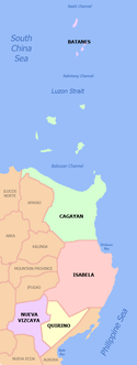
Quirino covers a total area of 3,323.47 square kilometres (1,283.20 sq mi)[8] occupying the southeastern section of the Cagayan Valley region. A landlocked province, it is situated within the upper portion of the Cagayan River basin and bounded by Isabela on the north, Aurora on the east and southeast, and Nueva Vizcaya on the west and southwest.
The Sierra Madre mountain range provides a natural barrier on the eastern and southern border of the province and the Mamparang Range on the western part. The province is generally mountainous, with about 80 percent of the total land area covered by mountains and highlands. A large portion of the province lies within the Quirino Protected Landscape.
Climate
The province has a mean annual temperature of 33.6 °C (92.5 °F).[citation needed] June is generally the warmest month and the wettest months are March to August,[citation needed] with the rest of the year being neither too dry nor too wet. Heavy, sustained rainfall occurs from September to November.
| Climate data for Quirino | |||||||||||||
|---|---|---|---|---|---|---|---|---|---|---|---|---|---|
| Month | Jan | Feb | Mar | Apr | May | Jun | Jul | Aug | Sep | Oct | Nov | Dec | Year |
| Average high °C (°F) | 27.4 (81.3) |
28.4 (83.1) |
29.6 (85.3) |
31.4 (88.5) |
32.2 (90.0) |
32.6 (90.7) |
32.0 (89.6) |
32.2 (90.0) |
32.0 (89.6) |
31.0 (87.8) |
29.6 (85.3) |
27.9 (82.2) |
30.5 (86.9) |
| Average low °C (°F) | 20.0 (68.0) |
20.3 (68.5) |
21.4 (70.5) |
22.6 (72.7) |
23.5 (74.3) |
23.9 (75.0) |
24.0 (75.2) |
23.9 (75.0) |
23.5 (74.3) |
23.0 (73.4) |
22.4 (72.3) |
20.8 (69.4) |
22.4 (72.4) |
| Average rainy days | 15 | 12 | 12 | 9 | 13 | 13 | 15 | 14 | 16 | 14 | 18 | 15 | 166 |
| Source: Storm247 [9] | |||||||||||||
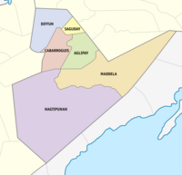
Administrative divisions
Quirino comprises 6 municipalities, all encompassed by a single legislative district.
|
| |||||||||||||||||||||||||||||||||||||||||||||||||||||||||||||||||||||||||||||||||||||||||||||||||||||||||||||||||||||||||||||||||||||
Barangays
The 6 municipalities of the province comprise a total of 132 barangays, with Gundaway (Poblacion) in Cabarroguis as the most populous in 2010, and Rang-ayan in Aglipay as the least. [11]
Demographics
| Year | Pop. | ±% p.a. |
|---|---|---|
| 1939 | 3,923 | — |
| 1948 | 2,520 | −4.80% |
| 1960 | 24,266 | +20.77% |
| 1970 | 49,767 | +7.44% |
| 1975 | 65,763 | +5.75% |
| 1980 | 83,230 | +4.82% |
| 1990 | 114,132 | +3.21% |
| 1995 | 131,119 | +2.63% |
| 2000 | 148,575 | +2.72% |
| 2007 | 163,610 | +1.34% |
| 2010 | 176,786 | +2.86% |
| 2015 | 188,991 | +1.28% |
| 2020 | 203,828 | +1.50% |
| Source: Philippine Statistics Authority [10] [11] [11] | ||
The population of Quirino in the 2020 census was 203,828 people, [2] with a density of 61 inhabitants per square kilometre or 160 inhabitants per square mile.
The major languages are Ilocano and Ifugao. Other languages are Bungkalot, Pangasinan, Kankana-ey, Tagalog, and English.
Religion
Quirino is predominantly Roman Catholic with 54 percent adherence[12] while Evangelicals and United Methodist Church serve as significant minorities with up to 20% of the population.[13] Some people still practice indigenous beliefs. Other Christians such as the Iglesia ni Cristo (forming more than 5% of the province population),[14] mainline Protestant and Aglipanyan are also well represented. Other religious groups are also have some minor adherents such as Islam.
Economy
Agriculture is the main industry in the province, with rice and corn as major crops.[22] These supply the demand of neighboring provinces and the metropolis. It is the leading producer of banana in the Cagayan Valley region.[22] Banana as well as banana chips are major products sold in Metro Manila and Pampanga. Small scale industries like furniture making, basketry, rattan craft, and dried flower production are prevalent.
Government
| Position | Name |
|---|---|
| District Representative | Dakila Carlo E. Cua |
| Provincial Governor | Junie E. Cua |
| Provincial Vice Governor | May G. Calaunan |
| Provincial Board Members | Jovino F. Navalta |
| Roldan E. Ubando | |
| Joel B. Badongen | |
| Elizabeth B. Saure | |
| Julius Caesar S. Vaquilar | |
| Magdalena A. Saladino | |
| Willard V. Abuan | |
| Tomas L. Baccac | |
References
- "List of Provinces". PSGC Interactive. Makati, Philippines: National Statistical Coordination Board. Archived from the original on January 17, 2013. Retrieved 19 December 2013.
- Census of Population (2020). "Region II (Cagayan Valley)". Total Population by Province, City, Municipality and Barangay. PSA. Retrieved 8 July 2021.
- "Republic Act No. 4734 - An Act Creating the Subprovince of Quirino in the Province of Nueva Vizcaya". Chan Robles Virtual Law Library. Retrieved 13 January 2015.
- "Brief History of Quirino". Province of Quirino (official website). Archived from the original on 6 March 2016. Retrieved 13 January 2015.
- "Republic Act No. 5554 - An Act Amending Republic Act Numbered Four Thousand Seven Hundred And Thirty-four, Entitled, "An Act Creating the Subprovince of Quirino in the Province of Nueva Vizcaya," and for Other Similar Purposes". Chan Robles Virtual Law Library. Retrieved 13 January 2015.
- "Republic Act No. 6394: An Act to Separate the Subprovince of Quirino from the Province of Nueva Vizcaya and Constitute It into a Regular Province to be Known as the Province of Quirino". Chan Robles Virtual Law Library. Retrieved 13 January 2015.
- "Batas Pambansa Blg. 345 – An Act Creating the Municipality of Nagtipunan, in the Province of Quirino". LGU.ph. Retrieved 13 January 2015.
- "Province: Quirino". PSGC Interactive. Quezon City, Philippines: Philippine Statistics Authority. Retrieved 8 January 2016.
- "Weather forecast for Quirino, Philippines". Storm247.com. Bergen, NO: StormGeo AS. Retrieved 21 April 2016.
- Census of Population (2015). "Region II (Cagayan Valley)". Total Population by Province, City, Municipality and Barangay. PSA. Retrieved 20 June 2016.
- Census of Population and Housing (2010). "Region II (Cagayan Valley)". Total Population by Province, City, Municipality and Barangay. NSO. Retrieved 29 June 2016.
- "MAP: Catholicism in the Philippines". Rappler. Archived from the original on 2018-06-22. Retrieved 2021-04-03.
- "Archived copy" (PDF). Archived from the original (PDF) on 2014-01-14. Retrieved 2017-10-09.
{{cite web}}: CS1 maint: archived copy as title (link) - "MAP: Iglesia ni Cristo in the Philippines". Rappler. Archived from the original on 2021-11-24. Retrieved 2021-04-03.
- "Poverty incidence (PI):". Philippine Statistics Authority. Retrieved 28 December 2020.
- https://psa.gov.ph/sites/default/files/NSCB_LocalPovertyPhilippines_0.pdf; publication date: 29 November 2005; publisher: Philippine Statistics Authority.
- https://psa.gov.ph/sites/default/files/2009%20Poverty%20Statistics.pdf; publication date: 8 February 2011; publisher: Philippine Statistics Authority.
- https://psa.gov.ph/sites/default/files/Table%202.%20%20Annual%20Per%20Capita%20Poverty%20Threshold%2C%20Poverty%20Incidence%20and%20Magnitude%20of%20Poor%20Population%2C%20by%20Region%20and%20Province%20%20-%202006%2C%202009%2C%202012%20and%202015.xlsx; publication date: 27 August 2016; publisher: Philippine Statistics Authority.
- https://psa.gov.ph/sites/default/files/Table%202.%20%20Annual%20Per%20Capita%20Poverty%20Threshold%2C%20Poverty%20Incidence%20and%20Magnitude%20of%20Poor%20Population%2C%20by%20Region%20and%20Province%20%20-%202006%2C%202009%2C%202012%20and%202015.xlsx; publication date: 27 August 2016; publisher: Philippine Statistics Authority.
- https://psa.gov.ph/sites/default/files/Table%202.%20%20Annual%20Per%20Capita%20Poverty%20Threshold%2C%20Poverty%20Incidence%20and%20Magnitude%20of%20Poor%20Population%2C%20by%20Region%20and%20Province%20%20-%202006%2C%202009%2C%202012%20and%202015.xlsx; publication date: 27 August 2016; publisher: Philippine Statistics Authority.
- https://psa.gov.ph/sites/default/files/Table%202.%20%20Updated%20Annual%20Per%20Capita%20Poverty%20Threshold%2C%20Poverty%20Incidence%20and%20Magnitude%20of%20Poor%20Population%20with%20Measures%20of%20Precision%2C%20by%20Region%20and%20Province_2015%20and%202018.xlsx; publication date: 4 June 2020; publisher: Philippine Statistics Authority.
- "The Province of Quirino". Department of Trade and Industry - Region 02. Archived from the original on 21 February 2020. Retrieved 26 June 2016.
External links
 Media related to Quirino (province) at Wikimedia Commons
 Geographic data related to Quirino at OpenStreetMap
- Official Website of the Provincial Government of Quirino
- Local Governance Performance Management System Archived 2016-03-04 at the Wayback Machine
Places adjacent to Quirino | ||||||||||||||||
|---|---|---|---|---|---|---|---|---|---|---|---|---|---|---|---|---|
| ||||||||||||||||
Cabarroguis (capital) | |
| Municipalities |
|
| Barangays | See: List of barangays in Quirino |
| ||||||||||||||||||||||||||||||||||||||||||||||||||||||

На других языках
[de] Quirino
Quirino ist eine Provinz in der Region Cagayan Valley auf der Insel Luzon auf den Philippinen.- [en] Quirino
[ru] Кирино (провинция)
Кирино (тагальск. Quirino) — провинция Филиппин, на острове Лусон. Входит в состав региона Долина Кагаян. Административный центр — город Кабаррогис (англ.) (рус..Другой контент может иметь иную лицензию. Перед использованием материалов сайта WikiSort.org внимательно изучите правила лицензирования конкретных элементов наполнения сайта.
WikiSort.org - проект по пересортировке и дополнению контента Википедии