world.wikisort.org - India
Parul is a village in the Pursurah CD block in the Arambagh subdivision of Hooghly district in the Indian state of West Bengal.
Parul | |
|---|---|
Village | |
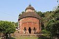
 Bishalakhi temple in Parul | |
 Parul Location in West Bengal, India  Parul Parul (India) | |
| Coordinates: 22.817578°N 87.936978°E | |
| Country | |
| State | West Bengal |
| District | Hooghly |
| Population (2011) | |
| • Total | 1,368 |
| Languages | |
| • Official | Bengali, English |
| Time zone | UTC+5:30 (IST) |
| PIN | 712401 |
| Telephone/STD code | 03212 |
| Lok Sabha constituency | Arambagh |
| Vidhan Sabha constituency | Pursurah |
| Website | hooghly |
Geography
M: municipal city/ town, R: rural/ urban centre, H: historical/ religious centre
Owing to space constraints in the small map, the actual locations in a larger map may vary slightly
Location
Parul is located at 22.817578°N 87.96978°E.
Area overview
The Arambagh subdivision, presented in the map alongside, is divided into two physiographic parts – the Dwarakeswar River being the dividing line. The western part is upland and rocky – it is extension of the terrain of neighbouring Bankura district. The eastern part is flat alluvial plain area. The railways, the roads and flood-control measures have had an impact on the area.[1] The area is overwhelmingly rural with 94.77% of the population living in rural areas and 5.23% of the population living in urban areas.[2]
Note: The map alongside presents some of the notable locations in the subdivision. All places marked in the map are linked in the larger full screen map.
Demographics
As per the 2011 Census of India, Parul had a total population of 1,368 of which 699 (51%) were males and 669 (49%) were females. Population in the age range 0–6 years was 141. The total number of literate persons in Parul was 1,038 (64.60% of the population over 6 years).[3]
Culture
David J. McCutchion mentions:[4]
- Raghunatha temple of the Chakrabarti family as a standard Hooghly-Bardhaman at chala, measuring 22’ 11" x 20’8", possibly built in 1768. It has panoramic battle scenes above the archways and smaller figures round the façade.
- Visalakshi temple as a Midnapore type at chala, measuring 19’6" square, built in 1859. The archways and other panels round the façade are filled with figures.
The Jor Bangla temple (at Sr No S-WB-56) and the Raghunandan temple (at Sr No S-WB-57) at Parul are included in the List of State Protected Monuments in West Bengal by the Archaeological Survey of India.[5]
Parul picture gallery
 Raghunandan temple of Chakrabarti family, at chala, built in 1768.
 Terracotta panel in Raghunandan temple.
 Terracotta decoration in Raghunandan temple.
 Bisalakshi temple, at-chala, built in 1859.
 Terracotta Panel in Bisalakshi temple.
 Decoration in Bisalakshi temple.


Click on the pictures to enlarge picture size
References
- "District Census Handbook: Hugli, Series-20, Part XIIA" (PDF). Physiography, Page 17-19. Directorate of Census Operations, West Bengal, 2011. Retrieved 25 September 2020.
- "District Statistical Handbook 2014 Hooghly". Table 2.2, 2.4(a). Department of Planning and Statistics, Government of West Bengal. Retrieved 25 September 2020.
- "2011 Census – Primary Census Abstract Data Tables". West Bengal – District-wise. Registrar General and Census Commissioner, India. Retrieved 22 September 2020.
- McCutchion, David J., Late Mediaeval Temples of Bengal, first published 1972, reprinted 2017, pages 35,36. The Asiatic Society, Kolkata, ISBN 978-93-81574-65-2
- "Protected Monuments in West Bengal". Archaeological Survey of India. Archived from the original on 2013-09-03. Retrieved 27 September 2020.
External links
Другой контент может иметь иную лицензию. Перед использованием материалов сайта WikiSort.org внимательно изучите правила лицензирования конкретных элементов наполнения сайта.
WikiSort.org - проект по пересортировке и дополнению контента Википедии