world.wikisort.org - India
Muzaffarpur District is one of the thirty-eight districts of Bihar state, India. Muzaffarpur district is part of and also the headquarters of Tirhut Division[1] Tirhut is the ancient name of all of northern Bihar.
This article possibly contains original research. (May 2020) |
Muzaffarpur district | |
|---|---|
District of Bihar | |
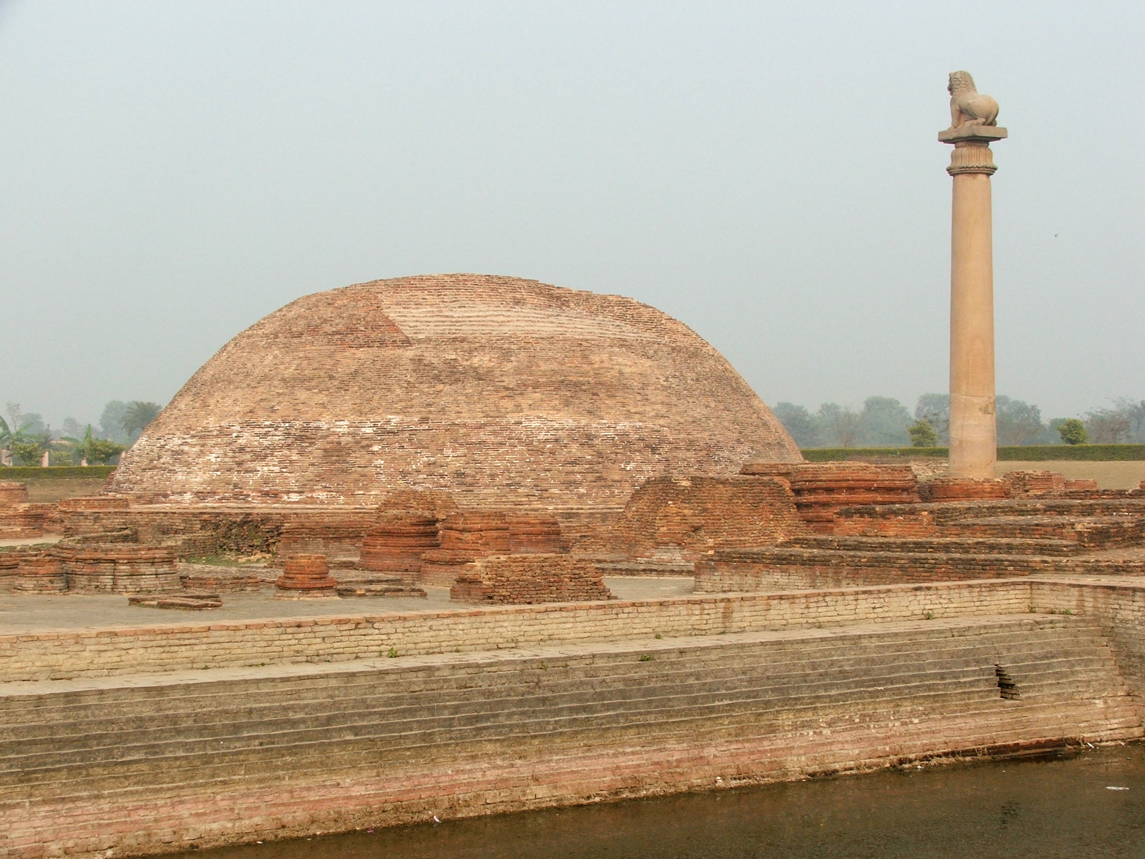 Ashokan Pillar, Kolhua | |
 Location of Muzaffarpur district in Bihar | |
| Country | |
| State | Bihar |
| Division | Tirhut |
| Headquarters | Muzaffarpur |
| Government | |
| • Lok Sabha constituencies | Muzaffarpur, Vaishali |
| • Vidhan Sabha constituencies | Gaighat, Aurai, Minapur, Bochahan, Sakra, Kurhani, Muzaffarpur, Kanti, Baruraj, Paroo, Sahebganj |
| Area | |
| • Total | 3,173 km2 (1,225 sq mi) |
| Population (2011) | |
| • Total | 4,801,062 |
| • Density | 1,500/km2 (3,900/sq mi) |
| Demographics | |
| • Literacy | |
| • Sex ratio | 900 |
| Time zone | UTC+05:30 (IST) |
| Major highways | NH 57, NH 28, NH 22, NH 102, NH 527C |
| Website | muzaffarpur |
History
Muzaffarpur was a part of the ancient Vajjika League, one of the principal mahājanapadas of Ancient India.
Muzaffarpur fostered political leaders and statesmen alike among whom were Maghfoor Ahmad Ajazi, George Fernandes, Janki Ballabh Shastri, a great Maithili writer Parmanandan Shashtri and Devesh Chandra Thakur. Bajjika and Maithili languages are spoken in the district.
In 1972 both Sitamarhi and Vaishali districts were split from Muzaffarpur.[2]
Geography
Muzaffarpur district is served by rivers Gandak, Budhi Gandak, Bagmati and Lakhandei. Many streams pass through the district. The area has been prone to floods. The district lies in the fertile region of Gangetic plain. Muzaffarpur district occupies an area of 3,175.9 square kilometres (1,226.2 sq mi),[3] comparatively equivalent to Canada's Mansel Island.[4]
Politics
| No. | Constituency | Name | Party | Alliance | Remarks | ||
|---|---|---|---|---|---|---|---|
| 88 | Gaighat | Niranjan Roy | Rashtriya Janata Dal | MGB | |||
| 89 | Aurai | Ram Surat Kumar | Bharatiya Janata Party | NDA | |||
| 90 | Minapur | Rajeev Kumar | Rashtriya Janata Dal | MGB | |||
| 91 | Bochahan | Amar Kumar Paswan | Rashtriya Janata Dal | MGB | Won in 2022 by-poll necessitated after the death of Musafir Paswan. | ||
| 92 | Sakra | Ashok Kumar Choudhary | Janata Dal (United) | MGB | |||
| 93 | Kurhani | Anil Kumar Sahni | Rashtriya Janata Dal | MGB | |||
| 94 | Muzaffarpur | Bijendra Chaudhary | Indian National Congress | MGB | |||
| 95 | Kanti | Mohammad Israil Mansuri | Rashtriya Janata Dal | MGB | |||
| 96 | Baruraj | Arun Kumar Singh | Bharatiya Janata Party | NDA | |||
| 97 | Paroo | Ashok Kumar Singh | Bharatiya Janata Party | NDA | |||
| 98 | Sahebganj | Raju Kumar Singh | Bharatiya Janata Party | NDA | Switched from VIP to BJP[5] | ||
Economy
GDP Per capita Income of Muzaffarpur is $2,507 and total GDP of District is $5 Billion as by 2021 Reports which is 4.7% of Bihar GDP.[6]
Lychee

The litchi crop, which is available from May to June, is mainly cultivated in the districts of Muzaffarpur and surrounding districts, in an area of about 25,800 hectares producing about 300,000 tonnes every year. Litchi is exported to big cities like Bombay, Kolkata and to other countries. India's share in the world litchi market amounts to less than 1%. The name of the litchi produced in quality.[7]
Industry
It has many industries ranging from small to big. Prabhat Zarda Factory, Ganesh Foundries Limited, Bharat Wagon and Engineering, N.T.P.C., Kanti Thermal Power Station, Bihar Drugs & Organic Chemicals Ltd., Muzaffarpur – a unit of IDPL, units of Leather Development Corporation, Muzaffarpur Dairy, a unit of the Bihar State Dairy Corporation unit Bihar State Cooperative Milk Producers’ Federation Ltd., Muzaffarpur producing Sudha brand packaged milk are the major industries located in Muzaffarpur city and its periphery. The above industries have generated considerable employment and have also been helpful in establishing a number of small industries including a few cottage industries. The most important item that is manufactured in Muzaffarpur town is railway wagon. Muzaffarpur city is an important centre for the wholesale cloth trade. Agriculture-based industries such as sugar mills and Britannia Biscuits have newly been established in city.[8]
Demographics
According to the 2011 census Muzaffarpur district has a population of 4,801,062,[citation needed] roughly equal to the nation of Singapore[9] or the US state of Alabama.[10] This gives it a ranking of 24th th in India (out of a total of 640). The district has a population density of 1,514 inhabitants per square kilometre (3,920/sq mi). Its population growth rate over the decade 2001-2011 was 28.14%. Muzaffarpur has a sex ratio of 900 females for every 1000 males, and a literacy rate of 63.4%. Scheduled Castes and Scheduled Tribes make up 15.66% and 0.12% of the population respectively.[11]
Languages
At the time of the 2011 Census of India, 48.33% of the population in the district spoke Hindi, 39.01% spoke Western Maithili, 7.65% Urdu and 3.54% Bhojpuri.
| Year | Pop. | ±% p.a. |
|---|---|---|
| 1901 | 1,078,094 | — |
| 1911 | 1,113,058 | +0.32% |
| 1921 | 1,077,631 | −0.32% |
| 1931 | 1,150,419 | +0.66% |
| 1941 | 1,269,186 | +0.99% |
| 1951 | 1,377,181 | +0.82% |
| 1961 | 1,598,346 | +1.50% |
| 1971 | 1,909,059 | +1.79% |
| 1981 | 2,357,388 | +2.13% |
| 1991 | 2,953,903 | +2.28% |
| 2001 | 3,746,714 | +2.41% |
| 2011 | 4,801,062 | +2.51% |
| source:[12] | ||
References
- "District Muzaffarpur, Government of Bihar | India". Retrieved 19 February 2021.
- Law, Gwillim (25 September 2011). "Districts of India". Statoids. Retrieved 11 October 2011.
- "Muzaffarpur Geographical At a Glance". Retrieved 10 July 2015.
- "Island Directory Tables: Islands by Land Area". United Nations Environment Program. 18 February 1998. Retrieved 11 October 2011.
Mansel Island 3,180km2
- "District Development Report" (PDF).
- "7. LYCHEE PRODUCTION IN INDIA". Fao.org. 31 May 1992. Retrieved 2 August 2014.
- "Muzaffarpur History | Muzaffarpur Geography | Muzaffarpur Climate | Muzaffarpur Economy | Muzaffarpur Demographics | Prominent People Born in Muzaffarpur". Archived from the original on 28 August 2011. Retrieved 11 March 2012.
- US Directorate of Intelligence. "Country Comparison:Population". Archived from the original on 13 June 2007. Retrieved 1 October 2011.
Singapore 4,740,737 July 2011 est.
- "2010 Resident Population Data". U. S. Census Bureau. Retrieved 30 September 2011.
Alabama 4,779,736
- "District Census 2011" (PDF). Census2011.co.in. 2011. Retrieved 19 February 2021.
- Decadal Variation In Population Since 1901
External links
Places adjacent to Muzaffarpur district | ||||||||||||||||
|---|---|---|---|---|---|---|---|---|---|---|---|---|---|---|---|---|
| ||||||||||||||||
Capital: Patna | |
| State symbols |
|
| History |
|
| Administration |
|
| Overviews |
|
| Divisions and districts | |
| Cities |
|
| Municipal Corporation |
|
| Politics |
|
| Culture |
|
Authority control | |
|---|---|
| General | |
| National libraries | |
На других языках
- [en] Muzaffarpur district
[ru] Музаффарпур (округ)
Музаффарпур (хинди मुज़फ़्फ़रपुर ज़िला; урду مُظفٌر پور ضلع; англ. Muzaffarpur) — округ на севере центральной части индийского штата Бихар. Административный центр — город Музаффарпур. Площадь округа — 3173 км². По данным всеиндийской переписи 2001 года население округа составляло 3 746 714 человек. Уровень грамотности взрослого населения составлял 47,95 %, что ниже среднеиндийского уровня (59,5 %). Махатма Ганди дважды посетил этот регион: в 1920 и в 1927 годах.Другой контент может иметь иную лицензию. Перед использованием материалов сайта WikiSort.org внимательно изучите правила лицензирования конкретных элементов наполнения сайта.
WikiSort.org - проект по пересортировке и дополнению контента Википедии