world.wikisort.org - Germany
Waldshut (German pronunciation: [ˌvalt͡sˈhuːt]) is a Landkreis (district) in the south of Baden-Württemberg, Germany. Neighbouring districts are (clockwise from the west) Lörrach, Breisgau-Hochschwarzwald and Schwarzwald-Baar; followed in the south by the Swiss cantons of Schaffhausen, Zürich and Aargau.
This article needs additional citations for verification. (December 2015) |
Waldshut | |
|---|---|
District | |
 Flag  Coat of arms | |
 | |
| Country | Germany |
| State | Baden-Württemberg |
| Adm. region | Freiburg |
| Capital | Waldshut-Tiengen |
| Area | |
| • Total | 1,131.18 km2 (436.75 sq mi) |
| Population (31 December 2020)[1] | |
| • Total | 171,237 |
| • Density | 150/km2 (390/sq mi) |
| Time zone | UTC+01:00 (CET) |
| • Summer (DST) | UTC+02:00 (CEST) |
| Vehicle registration | WT, SÄK |
| Website | http://www.landkreis-waldshut.de |
History
The district dates to the Oberamt Waldshut, which was created when the area became part of the state of Baden in the beginning of the 19th century. After some changes it was converted to a district in 1938. In 1973 the districts Säckingen and Hochschwarzwald were dissolved and were partially added to the district Waldshut, which then grew to its current size.
Geography
The district covers the southern part of the Black Forest. The river Rhine forms most of the boundary to Switzerland.
Coat of arms
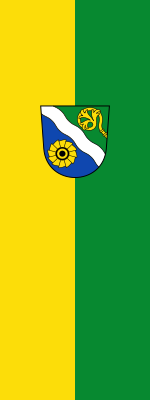
The present coat of arms was granted on December 11, 1973, superseding an older one. The bend wavy represents the river Rhine as the main river of the district. The wheel on a blue ground symbolizes the district's hydro-electric power industry (there was also a wheel in the old coat of arms). The abbot's staff was taken from the arms of the district of Säckingen, to symbolize its monasteries. Green is used to signify the Black Forest.
Towns and municipalities

| Towns | Municipalities |
|---|---|
|
|
| Verwaltungsgemeinschaften | |
|
References
- "Bevölkerung nach Nationalität und Geschlecht am 31. Dezember 2020" [Population by nationality and sex as of December 31, 2020] (CSV). Statistisches Landesamt Baden-Württemberg (in German). June 2021. Retrieved 17 October 2021.
External links
- (in German) Official website
- (in German) Information about the Waldshut region
- (in German) Waldshut district regional portal
- (in German) Waldshut district directory at Curlie
| Regions | |
|---|---|
| Urban districts | |
| Rural districts |
|
Districts of German states (Full list)
| |

Authority control | |
|---|---|
| General | |
| National libraries | |
На других языках
[de] Landkreis Waldshut
Der Landkreis Waldshut (alemannisch: Waldshuet) ist einer der vier südlichen Landkreise Baden-Württembergs an der Grenze zur Schweiz. Er gehört zur Region Hochrhein-Bodensee im Regierungsbezirk Freiburg. Verwaltungssitz ist das Landratsamt in Waldshut-Tiengen.- [en] Waldshut (district)
[ru] Вальдсхут (район)
Вальдсхут (нем. Waldshut), в литературе встречается название Вальдсгут[1][2] — район в современной Германии (ФРГ) на юге Шварцвальда.Другой контент может иметь иную лицензию. Перед использованием материалов сайта WikiSort.org внимательно изучите правила лицензирования конкретных элементов наполнения сайта.
WikiSort.org - проект по пересортировке и дополнению контента Википедии