world.wikisort.org - Germany
Göppingen is a Landkreis (district) in the middle of Baden-Württemberg, Germany. Neighboring districts are Rems-Murr, Ostalbkreis, Heidenheim, Alb-Donau, Reutlingen and Esslingen.
Göppingen | |
|---|---|
District | |
 Flag 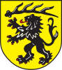 Coat of arms | |
 | |
| Country | Germany |
| State | Baden-Württemberg |
| Adm. region | Stuttgart |
| Capital | Göppingen |
| Area | |
| • Total | 642.35 km2 (248.01 sq mi) |
| Population (31 December 2020)[1] | |
| • Total | 258,781 |
| • Density | 400/km2 (1,000/sq mi) |
| Time zone | UTC+01:00 (CET) |
| • Summer (DST) | UTC+02:00 (CEST) |
| Vehicle registration | GP |
| Website | http://www.landkreis-goeppingen.de |
History
In 1817, Württemberg was divided into four kreise (districts), the southeastern one of which was named Donaukreis. The four kreise were in turn divided into oberämter. In Donaukreis, the most northern of these oberämter were Göppingen and, to its east, Geislingen. In 1938, the four kreise were abolished, and Geislingen was merged with Göppingen. During the communal reform of 1973 the district was not changed much, only a few municipalities from the districts Schwäbisch Gmünd and Ulm were added.
The district is sometimes called Stauferkreis, because the Staufen family had their roots in this area. However, when that family had no heir anymore, the land became part of Württemberg in the 14th century.
Partnerships
In 1990 a partnership with the district Löbau (now merged into the district of Görlitz) in Saxony was started, to help to build the administration according to western German standards. The municipality Boll already had a partnership with Herrnhut in Löbau before. After the districts started their partnership, several other municipalities of the two districts started partnership as well.
Geography
The district is located in the northern foothills of the Swabian Jura (Schwäbische Alb). It is crossed by the Fils, a tributary of the Neckar.
Coat of arms
The lion is the symbol of the Staufen family, which had its roots in the district. The deer antler above is the symbol of Württemberg and symbolizes the change of ownership after the Staufer family died out.
Cities and municipalities

| Cities | Administrative districts | Municipalities | |
|---|---|---|---|
|
References
- "Bevölkerung nach Nationalität und Geschlecht am 31. Dezember 2020" [Population by nationality and sex as of December 31, 2020] (CSV). Statistisches Landesamt Baden-Württemberg (in German). June 2021. Retrieved 17 October 2021.
External links
- Official website (German)
| Regions | |
|---|---|
| Urban districts | |
| Rural districts |
|
Districts of German states (Full list)
| |
На других языках
[de] Landkreis Göppingen
Der Landkreis Göppingen ist ein Landkreis in Baden-Württemberg. Er gehört zur Region Stuttgart im Regierungsbezirk Stuttgart und erstreckt sich von Nord nach Süd von Adelberg bis Hohenstadt, in Ost-West-Richtung von Ebersbach an der Fils bis Böhmenkirch.- [en] Göppingen (district)
[ru] Гёппинген (район)
Гёппинген (нем. Göppingen) — район в Германии. Центр района — город Гёппинген. Район входит в землю Баден-Вюртемберг. Подчинён административному округу Штутгарт. Занимает площадь 642,36 км². Население — 257 314 чел. Плотность населения — 401 человек/км². Официальный код района — 08 1 17.Другой контент может иметь иную лицензию. Перед использованием материалов сайта WikiSort.org внимательно изучите правила лицензирования конкретных элементов наполнения сайта.
WikiSort.org - проект по пересортировке и дополнению контента Википедии