world.wikisort.org - Germany
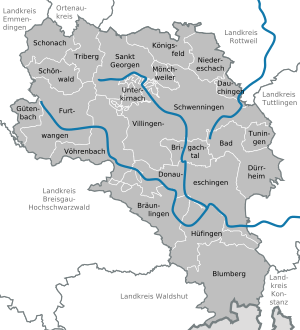
Schwarzwald-Baar (German pronunciation: [ˌʃvaʁtsvaltˈbaːɐ̯]) is a Landkreis (district) in the south of Baden-Württemberg, Germany. Neighboring districts are (from north clockwise) Ortenaukreis, Rottweil, Tuttlingen, Constance, the Swiss canton of Schaffhausen, and the districts Waldshut, Breisgau-Hochschwarzwald and Emmendingen.
This article may be expanded with text translated from the corresponding article in German. (February 2022) Click [show] for important translation instructions.
|
This article relies largely or entirely on a single source. (August 2020) |
Schwarzwald-Baar-Kreis | |
|---|---|
District | |
 | |
 Flag  Coat of arms | |
 | |
| Country | Germany |
| State | Baden-Württemberg |
| Adm. region | Freiburg |
| Capital | Villingen-Schwenningen |
| Area | |
| • Total | 1,025.23 km2 (395.84 sq mi) |
| Population (31 December 2020)[1] | |
| • Total | 212,872 |
| • Density | 210/km2 (540/sq mi) |
| Time zone | UTC+01:00 (CET) |
| • Summer (DST) | UTC+02:00 (CEST) |
| Vehicle registration | VS |
| Website | http://www.schwarzwald-baar-kreis.de |
History
The district was created in 1973, when the districts of Donaueschingen and Villingen were merged.[citation needed]
Geography
The district got its name from the two predominant landscapes in the district. The Black Forest (Schwarzwald), and the Baar, the foothills between the Black Forest and the Swabian Alb. Both the Danube River and the Neckar River have their origins in the Schwarzwald and Baar district.
Coat of arms
This section does not cite any sources. (August 2022) |
The coat of arms is modeled after the two coat of arms of the cities of Villingen and Schwenningen. Villingen had a horizontally divided blue-and-white arms, while Schwenningen had a vertically divided blue-and-white arms. Combining both divisions gives the four fields. The eagle in the top-left quarter is taken from the coat of arms of the city of Villingen, and derives from the Zähringen family who ruled that city in the 13th century.
Cities and towns
| Cities | Administrative districts | Towns |
|---|---|---|
|
References
- "Bevölkerung nach Nationalität und Geschlecht am 31. Dezember 2020" [Population by nationality and sex as of December 31, 2020] (CSV). Statistisches Landesamt Baden-Württemberg (in German). June 2021. Retrieved 17 October 2021.
External links
- Official website (German)
| Regions | |
|---|---|
| Urban districts | |
| Rural districts |
|
Districts of German states (Full list)
| |

Authority control | |
|---|---|
| General | |
| National libraries | |
На других языках
[de] Schwarzwald-Baar-Kreis
Der Schwarzwald-Baar-Kreis ist ein Landkreis in Baden-Württemberg. Er gehört zur Region Schwarzwald-Baar-Heuberg im Regierungsbezirk Freiburg und erstreckt sich auf das Gebiet zwischen Schwarzwald und Schwäbischer Alb. Hier entspringen sowohl die Donau und ihre Quellflüsse Brigach und Breg als auch der Neckar, weshalb der Kreis auch als Quellenland bezeichnet wird.[2]- [en] Schwarzwald-Baar-Kreis
[ru] Шварцвальд-Бар (район)
Шварцвальд-Бар (нем. Schwarzwald-Baar-Kreis) — район в Германии. Центр района — город Филлинген-Швеннинген. Район входит в землю Баден-Вюртемберг. Подчинён административному округу Фрайбург. Занимает площадь 1025,24 км². Население — 210 971 чел. Плотность населения — 206 человек/км². Официальный код района — 08 3 26.Другой контент может иметь иную лицензию. Перед использованием материалов сайта WikiSort.org внимательно изучите правила лицензирования конкретных элементов наполнения сайта.
WikiSort.org - проект по пересортировке и дополнению контента Википедии