world.wikisort.org - Germany
Lörrach is a Landkreis (district) in the southwest of Baden-Württemberg, Germany. Neighboring districts are Breisgau-Hochschwarzwald and Waldshut. To the west it borders the French département Haut-Rhin; to the south the Swiss cantons Basel-Stadt, Basel-Landschaft and Aargau.
Lörrach | |
|---|---|
District | |
 Flag  Coat of arms | |
 | |
| Country | Germany |
| State | Baden-Württemberg |
| Adm. region | Freiburg |
| Capital | Lörrach |
| Area | |
| • Total | 806.81 km2 (311.51 sq mi) |
| Population (31 December 2020)[1] | |
| • Total | 228,842 |
| • Density | 280/km2 (730/sq mi) |
| Time zone | UTC+01:00 (CET) |
| • Summer (DST) | UTC+02:00 (CEST) |
| Vehicle registration | LÖ |
| Website | www |
History
In 1973 part of the district Müllheim and small parts of the district Säckingen were added to the district, which enlarged the district by about 25% to the current size.
Geography
The north-east of the district is part of the Hochschwarzwald, the highest part of the Black Forest. In the west is the Markgräfler Hügelland, in the south the Dinkelberg, both lower hilly areas. The Rhine river, which forms most of the district's southern and western border, is in a narrow valley until it spreads north of Basel in the much wider Oberrheinebene. The district is included in the trinational Basel metropolitan area.
Coat of arms
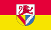
The coat of arms of the Lörrach district can be blazoned as Per fess Argent a Demi Lion facing sinister Gules and in base per pale Or a Bend Gules and Azure a Bend Sinister wavy Argent. The lion in the top part of the coat of arms represents the Lords of Rötteln, who had their primary castle in Loerrach, Wiesental. The bottom-left shows the coat of Baden, as much of the district belonged to the Counts of Baden historically. The wavy line in the bottom-right represents the small river Wiese, which flows through the district.
Towns and municipalities

| Towns | Municipalities | |
|---|---|---|
References
- "Bevölkerung nach Nationalität und Geschlecht am 31. Dezember 2020" [Population by nationality and sex as of December 31, 2020] (CSV). Statistisches Landesamt Baden-Württemberg (in German). June 2021. Retrieved 17 October 2021.
External links
- Official website (in German)
- Lörrach: images and history (in German)
| Regions | |
|---|---|
| Urban districts | |
| Rural districts |
|
Districts of German states (Full list)
| |

На других языках
[de] Landkreis Lörrach
Der Landkreis Lörrach ist ein Landkreis im äußersten Südwesten des Bundeslandes Baden-Württemberg (Deutschland). Er gehört zum Regierungsbezirk Freiburg und zum Regionalverband Hochrhein-Bodensee.- [en] Lörrach (district)
[ru] Лёррах (район)
Лёррах (нем. Lörrach) — район в Германии. Центр района — город Лёррах. Район входит в землю Баден-Вюртемберг. Подчинён административному округу Фрайбург. Занимает площадь 806,81 км². Население — 221 572 чел. Плотность населения — 275 человек/км². Официальный код района — 08 3 36.Другой контент может иметь иную лицензию. Перед использованием материалов сайта WikiSort.org внимательно изучите правила лицензирования конкретных элементов наполнения сайта.
WikiSort.org - проект по пересортировке и дополнению контента Википедии