world.wikisort.org - Germany
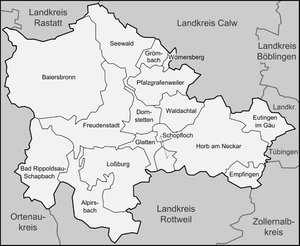
Freudenstadt is a Landkreis (district) in the middle of Baden-Württemberg, Germany. Neighboring districts are (from north clockwise) Rastatt, Calw, Tübingen, Zollernalbkreis, Rottweil and the Ortenaukreis.
Freudenstadt | |
|---|---|
District | |
 | |
| Country | Germany |
| State | Baden-Württemberg |
| Adm. region | Karlsruhe |
| Capital | Freudenstadt |
| Area | |
| • Total | 870.68 km2 (336.17 sq mi) |
| Population (31 December 2020)[1] | |
| • Total | 118,364 |
| • Density | 140/km2 (350/sq mi) |
| Time zone | UTC+01:00 (CET) |
| • Summer (DST) | UTC+02:00 (CEST) |
| Vehicle registration | FDS |
| Website | http://www.landkreis-freudenstadt.de |
History
The district was created in 1938 as the successor of the Oberamt Freudenstadt which dated back to 1806. In 1973 it was merged with the majority of the neighboring district of Horb, and some small parts of the districts of Wolfach and Hechingen.
Geography
The district is located in the middle part of the Black Forest mountains. The river Neckar flows through the southeast of the district.
Coat of arms
 |
The coat of arms displays a capercaillie, which once was quite common in the area. The colors yellow and black are chosen as they are the colors of Württemberg. |
Towns and municipalities
| Cities | Towns |
|---|---|
| Administrative districts | |
|
References
- "Bevölkerung nach Nationalität und Geschlecht am 31. Dezember 2020" [Population by nationality and sex as of December 31, 2020] (CSV). Statistisches Landesamt Baden-Württemberg (in German). June 2021. Retrieved 17 October 2021.
External links
Wikimedia Commons has media related to Landkreis Freudenstadt.
- Official website (German, English, French)
| Regions | |
|---|---|
| Urban districts | |
| Rural districts |
|
Districts of German states (Full list)
| |
Towns and municipalities in Freudenstadt (district) | ||
|---|---|---|
 | ||
Authority control | |
|---|---|
| General | |
| National libraries | |
На других языках
[de] Landkreis Freudenstadt
Der Landkreis Freudenstadt ist eine Gebietskörperschaft mit 119.183 Einwohnern (31. Dezember 2021) im Regierungsbezirk Karlsruhe in Baden-Württemberg. Er gehört zur Raumordnungsregion Nordschwarzwald. Verwaltungssitz des Landkreises ist die Große Kreisstadt Freudenstadt. Der Landkreis Freudenstadt ist hinsichtlich der Einwohnerzahl der zweitkleinste Baden-Württembergs (kleiner ist lediglich der Hohenlohekreis).- [en] Freudenstadt (district)
[ru] Фройденштадт (район)
Фройденштадт (нем. Freudenstadt) — район в Германии. Центр района — город Фройденштадт. Район входит в землю Баден-Вюртемберг. Подчинён административному округу Карлсруэ. Занимает площадь 870,68 км². Население — 122 514 чел. Плотность населения — 141 человек/км². Официальный код района — 08 2 37.Текст в блоке "Читать" взят с сайта "Википедия" и доступен по лицензии Creative Commons Attribution-ShareAlike; в отдельных случаях могут действовать дополнительные условия.
Другой контент может иметь иную лицензию. Перед использованием материалов сайта WikiSort.org внимательно изучите правила лицензирования конкретных элементов наполнения сайта.
Другой контент может иметь иную лицензию. Перед использованием материалов сайта WikiSort.org внимательно изучите правила лицензирования конкретных элементов наполнения сайта.
2019-2026
WikiSort.org - проект по пересортировке и дополнению контента Википедии
WikiSort.org - проект по пересортировке и дополнению контента Википедии