world.wikisort.org - Germany
Hohentengen is a municipality in the district of Waldshut in Baden-Württemberg in Germany.
This article may be expanded with text translated from the corresponding article in German. (February 2009) Click [show] for important translation instructions.
|
Hohentengen am Hochrhein | |
|---|---|
Municipality | |
 Schloss Rötteln | |
 Coat of arms | |
Location of Hohentengen am Hochrhein within Waldshut district 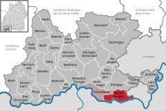 | |
 Hohentengen am Hochrhein  Hohentengen am Hochrhein | |
| Coordinates: 47°34′12″N 08°26′02″E | |
| Country | Germany |
| State | Baden-Württemberg |
| Admin. region | Freiburg |
| District | Waldshut |
| Government | |
| • Mayor (2015–23) | Martin Benz[1] |
| Area | |
| • Total | 27.55 km2 (10.64 sq mi) |
| Elevation | 368 m (1,207 ft) |
| Population (2020-12-31)[2] | |
| • Total | 3,957 |
| • Density | 140/km2 (370/sq mi) |
| Time zone | UTC+01:00 (CET) |
| • Summer (DST) | UTC+02:00 (CEST) |
| Postal codes | 79801 |
| Dialling codes | 07742 |
| Vehicle registration | WT |
| Website | www.hohentengen.de |
Geography
Location
The village Hohentengen lies on the northern banks of the Rhine, overlooking Switzerland. The right weather conditions allow a view of the Swiss Alpes from the 'Kalten Wangen', a mountain in the district of Stetten. Hohentengen am Hochrhein comprises six districts: Hohentengen, Lienheim, Herdern, Bergöschingen, Günzgen and Stetten.
Neighbouring towns
Hohentengen borders to Klettgau in the north, the Swiss towns of Wasterkingen and Hüntwangen in the east, Glattfelden and Weiach in the south, which are all part of the Kanton Zürich, as well as Kaiserstuhl, Aargau, Fisibach, and Rümikon, which are part of the Kanton Aargau. In the west, Hohentengen borders to the German town of Küssaberg.
References
- Aktuelle Wahlergebnisse, Staatsanzeiger, accessed 15 September 2021.
- "Bevölkerung nach Nationalität und Geschlecht am 31. Dezember 2020" [Population by nationality and sex as of December 31, 2020] (CSV). Statistisches Landesamt Baden-Württemberg (in German). June 2021. Retrieved 17 October 2021.
| Wikimedia Commons has media related to Hohentengen am Hochrhein. |
Towns and municipalities in Waldshut (district) | ||
|---|---|---|
|  | |
This Waldshut location article is a stub. You can help Wikipedia by expanding it. |
На других языках
- [en] Hohentengen am Hochrhein
[ru] Хоэнтенген (Верхний Рейн)
Хоэнтенген (нем. Hohentengen am Hochrhein) — коммуна в Германии, в земле Баден-Вюртемберг.Другой контент может иметь иную лицензию. Перед использованием материалов сайта WikiSort.org внимательно изучите правила лицензирования конкретных элементов наполнения сайта.
WikiSort.org - проект по пересортировке и дополнению контента Википедии