world.wikisort.org - France
Barfleur (French pronunciation: [baʁflœʁ]) is a commune and fishing village in Manche, Normandy, northwestern France.
Barfleur | |
|---|---|
Commune | |
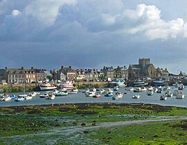
 Barfleur harbour | |
Location of Barfleur  | |
 Barfleur  Barfleur | |
| Coordinates: 49°40′16″N 1°15′48″W | |
| Country | France |
| Region | Normandy |
| Department | Manche |
| Arrondissement | Cherbourg |
| Canton | Val-de-Saire |
| Intercommunality | CA Cotentin |
| Area 1 | 0.6 km2 (0.2 sq mi) |
| Population | 559 |
| • Density | 930/km2 (2,400/sq mi) |
| Time zone | UTC+01:00 (CET) |
| • Summer (DST) | UTC+02:00 (CEST) |
| INSEE/Postal code | 50030 /50760 |
| 1 French Land Register data, which excludes lakes, ponds, glaciers > 1 km2 (0.386 sq mi or 247 acres) and river estuaries. | |
History
During the Middle Ages, Barfleur was one of the chief ports of embarkation for England.[2]
- 1066: A large medallion fixed to a rock in the harbour marks the Normans' departure from Barfleur before the battle of Hastings.
- 1120: The White Ship, carrying the sole legitimate heir to Henry I of England, William Adelin, went down outside the harbour, setting the stage for the period of civil war in England known as the Anarchy.[2]
- 1194: Richard I of England departed from Barfleur on return to England following his captivity by Henry VI, Holy Roman Emperor.
- 1692: Action at Barfleur, part of the battles of Barfleur and La Hogue
- 1944: Barfleur was occupied by the Germans during WWII. As allied forces approached following the D-Day invasion, the German commander evacuated the city prior to any confrontation to ensure that it would not be damaged, as he liked the city so much.
Demographics
| Year | Pop. | ±% |
|---|---|---|
| 1793 | 896 | — |
| 1856 | 1,279 | +42.7% |
| 1896 | 1,189 | −7.0% |
| 1946 | 977 | −17.8% |
| 2009 | 648 | −33.7% |
Geography
About two miles (3.2 km) to the north is Cape Barfleur, with a lighthouse 233 feet (71 m) high.[2] It is twinned with Lyme Regis in the UK. A Brittany Ferries vessel is named after the village and operates from nearby Cherbourg-Octeville to Poole in the UK.
See also
Footnotes
- "Populations légales 2019". The National Institute of Statistics and Economic Studies. 29 December 2021.
- Chisholm, Hugh, ed. (1911). "Barfleur". Encyclopædia Britannica (11th ed.). Cambridge University Press.
External links
Wikimedia Commons has media related to Barfleur.
- Official website (in French)
На других языках
- [en] Barfleur
[ru] Барфлёр
Барфлёр (фр. Barfleur) — французский порт на берегу Ла-Манша, на полуострове Котантен. Административно коммуна региона Нормандия, департамент Манш.Текст в блоке "Читать" взят с сайта "Википедия" и доступен по лицензии Creative Commons Attribution-ShareAlike; в отдельных случаях могут действовать дополнительные условия.
Другой контент может иметь иную лицензию. Перед использованием материалов сайта WikiSort.org внимательно изучите правила лицензирования конкретных элементов наполнения сайта.
Другой контент может иметь иную лицензию. Перед использованием материалов сайта WikiSort.org внимательно изучите правила лицензирования конкретных элементов наполнения сайта.
2019-2025
WikiSort.org - проект по пересортировке и дополнению контента Википедии
WikiSort.org - проект по пересортировке и дополнению контента Википедии