world.wikisort.org - France
Gargilesse-Dampierre (French pronunciation: [ɡaʁʒilɛs dɑ̃pjɛʁ]) is a commune in the Indre department in central France.
Gargilesse-Dampierre | |
|---|---|
Commune | |
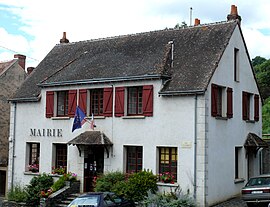
 The town hall in Gargilesse | |
Location of Gargilesse-Dampierre  | |
 Gargilesse-Dampierre  Gargilesse-Dampierre | |
| Coordinates: 46°30′52″N 1°35′52″E | |
| Country | France |
| Region | Centre-Val de Loire |
| Department | Indre |
| Arrondissement | Châteauroux |
| Canton | Argenton-sur-Creuse |
| Government | |
| • Mayor (2021–2026) | Martine Sabroux-Idoux[1] |
| Area 1 | 15.72 km2 (6.07 sq mi) |
| Population | 280 |
| • Density | 18/km2 (46/sq mi) |
| Time zone | UTC+01:00 (CET) |
| • Summer (DST) | UTC+02:00 (CEST) |
| INSEE/Postal code | 36081 /36190 |
| Elevation | 124–275 m (407–902 ft) (avg. 221 m or 725 ft) |
| 1 French Land Register data, which excludes lakes, ponds, glaciers > 1 km2 (0.386 sq mi or 247 acres) and river estuaries. | |
It is classified as one of "The most beautiful villages of France" and is situated near the confluence of the Gargilesse stream and the river Creuse. The 19th century writer George Sand lived in the village.
Population
|
|
See also
References
- "Répertoire national des élus: les maires". data.gouv.fr, Plateforme ouverte des données publiques françaises (in French). 9 August 2021.
- "Populations légales 2019". The National Institute of Statistics and Economic Studies. 29 December 2021.
Wikimedia Commons has media related to Gargilesse-Dampierre.
На других языках
- [en] Gargilesse-Dampierre
[ru] Гаржилес-Дампьер
Гаржиле́с-Дампье́р (фр. Gargilesse-Dampierre) — коммуна во Франции, в округе Ла-Шатре департамента Эндр, Центр — Долина Луары. Расположен на расстоянии[1] около 270 км на юг от Парижа, 160 км на юг от Орлеана, 34 км на юг от Шатору.Текст в блоке "Читать" взят с сайта "Википедия" и доступен по лицензии Creative Commons Attribution-ShareAlike; в отдельных случаях могут действовать дополнительные условия.
Другой контент может иметь иную лицензию. Перед использованием материалов сайта WikiSort.org внимательно изучите правила лицензирования конкретных элементов наполнения сайта.
Другой контент может иметь иную лицензию. Перед использованием материалов сайта WikiSort.org внимательно изучите правила лицензирования конкретных элементов наполнения сайта.
2019-2025
WikiSort.org - проект по пересортировке и дополнению контента Википедии
WikiSort.org - проект по пересортировке и дополнению контента Википедии