world.wikisort.org - France
La Meauffe (French pronunciation: [la mof]) is a commune in the Manche department in Normandy in north-western France.
La Meauffe | |
|---|---|
Commune | |
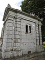
 The church, destroyed in July 1944 and rebuilt after the war | |
 Coat of arms | |
Location of La Meauffe  | |
 La Meauffe  La Meauffe | |
| Coordinates: 49°10′37″N 1°06′34″W | |
| Country | France |
| Region | Normandy |
| Department | Manche |
| Arrondissement | Saint-Lô |
| Canton | Pont-Hébert |
| Intercommunality | Saint-Lô Agglo |
| Government | |
| • Mayor (2020–2026) | Alain Mahieu |
| Area 1 | 10.22 km2 (3.95 sq mi) |
| Population | 1,019 |
| • Density | 100/km2 (260/sq mi) |
| Demonym(s) | Meauffois |
| Time zone | UTC+01:00 (CET) |
| • Summer (DST) | UTC+02:00 (CEST) |
| INSEE/Postal code | 50297 /50880 |
| Elevation | 4–87 m (13–285 ft) |
| Website | pagesperso-orange.fr/mairie.la-meauffe |
| 1 French Land Register data, which excludes lakes, ponds, glaciers > 1 km2 (0.386 sq mi or 247 acres) and river estuaries. | |
History

The 11 and 12 July 1944, the village was attacked by the American 35th ID, while defended by the German 352 ID and units of the 266 ID. The fighting, violent, started the 11th and ended the 12th, cost the lives of 19 US soldiers, wounding 170, with 25 missing. The road D54, leading to La Meauffe was renamed the Death Valley Road by the US soldiers.[2]
 Funeral chapel, with bullet and shrapnel holes.
 Stone memorial for the 35th ID.
 Shrapnel holes on a headstone.
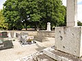 Stone of the Calvary cross, marked by the fighting.


Heraldry
 |
The arms of La Meauffe are blazoned : Vert, a fess wavy argent between 2 fleurs de lys Or, and a salmon argent.
|
See also
References
- "Populations légales 2019". The National Institute of Statistics and Economic Studies. 29 December 2021.
- La Meauffe en 1944, sur dday-overlord.com
Wikimedia Commons has media related to La Meauffe.
Communes of the Manche department | |
|---|---|
| Prefecture |
|
| Subprefectures | |
| Other |
|
This Manche geographical article is a stub. You can help Wikipedia by expanding it. |
Текст в блоке "Читать" взят с сайта "Википедия" и доступен по лицензии Creative Commons Attribution-ShareAlike; в отдельных случаях могут действовать дополнительные условия.
Другой контент может иметь иную лицензию. Перед использованием материалов сайта WikiSort.org внимательно изучите правила лицензирования конкретных элементов наполнения сайта.
Другой контент может иметь иную лицензию. Перед использованием материалов сайта WikiSort.org внимательно изучите правила лицензирования конкретных элементов наполнения сайта.
2019-2026
WikiSort.org - проект по пересортировке и дополнению контента Википедии
WikiSort.org - проект по пересортировке и дополнению контента Википедии