world.wikisort.org - Ecuador
Patate Canton is a canton of Ecuador, located in the Tungurahua Province. Its capital is the town of Patate. Its population at the 2010 census was 13,497.[1]
Patate Canton | |
|---|---|
Canton | |
 Tungurahua Province in Ecuador | |
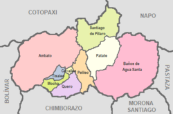 Cantons of Tungurahua Province | |
| Coordinates: 01°19′S 78°31′W | |
| Country | |
| Province | Tungurahua Province |
| Capital | Patate |
| Government | |
| • Mayor | Medardo Chiliquinga |
| Area | |
| • Total | 315 km2 (122 sq mi) |
| Population (2010) | |
| • Total | 13,497 |
| • Density | 42.85/km2 (111.0/sq mi) |
| Time zone | UTC-5 (ECT) |
| Area code | 593 |
| Website | Patate Autonomous Decentralized Government |
The still active Tungurahua volcano is situated within the canton.
Patate (town and canton) was declared a Pueblo Mágico (magical town) by Ecuador's Ministry of Tourism (MINTUR) in 2019. It was the first community in the country to be awarded this distinction.[2]
References
- "Estadísticas de la Semana". Archived from the original on 2014-02-26. Retrieved 2014-02-26. at statoids.com
- "Patate es oficialmente un 'Pueblo Mágico' del país". El Comercio. Retrieved 2021-04-02.
External links
This Ecuador location article is a stub. You can help Wikipedia by expanding it. |
Текст в блоке "Читать" взят с сайта "Википедия" и доступен по лицензии Creative Commons Attribution-ShareAlike; в отдельных случаях могут действовать дополнительные условия.
Другой контент может иметь иную лицензию. Перед использованием материалов сайта WikiSort.org внимательно изучите правила лицензирования конкретных элементов наполнения сайта.
Другой контент может иметь иную лицензию. Перед использованием материалов сайта WikiSort.org внимательно изучите правила лицензирования конкретных элементов наполнения сайта.
2019-2026
WikiSort.org - проект по пересортировке и дополнению контента Википедии
WikiSort.org - проект по пересортировке и дополнению контента Википедии