world.wikisort.org - Ecuador
Zamora is a canton in the Zamora-Chinchipe Province of Ecuador. It was named after Zamora city, the provincial capital and head of the canton of the same name.
This article does not cite any sources. (April 2008) |
Zamora Canton
Ciudad de Aves y Cascadas | |
|---|---|
Canton | |
 Flag | |
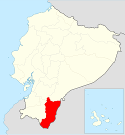 Location of Zamora Chinchipe Province in Ecuador. | |
 Cantons of Zamora Chinchipe Province | |
| Coordinates: 4.12°S 78.80°W | |
| Country | |
| Province | Zamora-Chinchipe Province |
| Area | |
| • Total | 724 sq mi (1,876 km2) |
| Elevation | 2,949 ft (899 m) |
| Time zone | UTC-5 (ECT) |
| Website | https://www.zamora.gob.ec/ |
History
On October 11, 1911, the Zamora Canton was created in the great former Provincia de Oriente, later in 1921 it became part of the Santiago-Zamora Province and in 1953, it permanently became part of the actual province.
General information
The canton is known for being one of the oldest and the largest canton in area of the province. It is surrounded by the remaining cantons, with exception of the Chinchipe, El Pangui and Paquisha cantons. To the west the canton borders with the Loja Province.
The Zamora Canton is the entrance from the Sierra Region towards the rest of the province by the Troncal Amazónica Highway, in a stretch of 62 kilometers from Loja city.
Political division
The canton is divided in 7 parishes, to wit:
- Cumbaratza
- Guadalupe
- El Limón
- Imbana
- Sabanilla
- San Carlos
- Timbara
- Zamora
This Ecuador location article is a stub. You can help Wikipedia by expanding it. |
|
| Azuay | |
|---|---|
| Bolívar | |
| Cañar |
|
| Carchi |
|
| Chimborazo |
|
| Cotopaxi |
|
| El Oro |
|
| Esmeraldas |
|
| Galápagos |
|
| Guayas |
|
| Imbabura | |
| Loja | |
| Los Ríos |
|
| Manabí |
|
| Morona-Santiago |
|
| Napo |
|
| Orellana |
|
| Pastaza |
|
| Pichincha |
|
| Santa Elena |
|
| Santo Domingo de los Tsáchilas |
|
| Sucumbíos |
|
| Tungurahua | |
| Zamora-Chinchipe |
|
На других языках
[de] Kanton Zamora
Der Kanton Zamora befindet sich in der Provinz Zamora Chinchipe im Süden von Ecuador. Er besitzt eine Fläche von 1898 km². Im Jahr 2020 lag die Einwohnerzahl schätzungsweise bei 32.760. Verwaltungssitz des Kantons ist die Provinzhauptstadt Zamora mit 12.386 Einwohnern (Stand 2010). Der Kanton Zamora wurde im Jahr 1911 eingerichtet.- [en] Zamora Canton
Другой контент может иметь иную лицензию. Перед использованием материалов сайта WikiSort.org внимательно изучите правила лицензирования конкретных элементов наполнения сайта.
WikiSort.org - проект по пересортировке и дополнению контента Википедии