world.wikisort.org - Colombia
Huila (Spanish pronunciation: [ˈwila]) is one of the departments of Colombia. It is located in the southwest of the country, and its capital is Neiva.[3]
Department of Huila
Departamento del Huila | |
|---|---|
Department | |
 Flag  Coat of arms | |
| Anthem: Alma del Huila (Huila's soul) | |
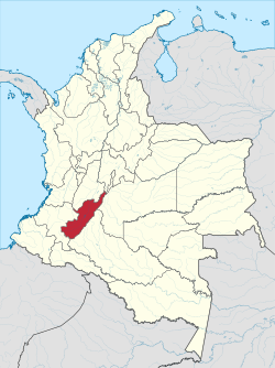 Huila shown in red | |
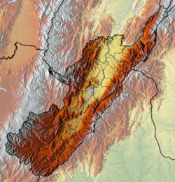 Topography of the department | |
| Coordinates: 2°59′55″N 75°18′16″W | |
| Country | |
| Region | Andean Region |
| Established | 1905 |
| Capital | Neiva |
| Government | |
| • Governor | Luis Enrique Dussan López |
| Area | |
| • Total | 19,890 km2 (7,680 sq mi) |
| • Rank | 26th |
| Population (2018)[1] | |
| • Total | 1,200,386 |
| • Rank | 15th |
| • Density | 60/km2 (160/sq mi) |
| Time zone | UTC-05 |
| ISO 3166 code | CO-HUI |
| Provinces | 4 |
| Municipalities | 37 |
| HDI (2019) | 0.726[2] high · 22nd of 33 |
| Website | https://www.huila.gov.co/ |
Demography and Ethnography
Huila is a department that has a population of 1,122,622 inhabitants, of which 679,667 (60.54%) people live in municipal capitals and 442,955 (39.46%) in the rest of the Huilense territory.[4] This corresponds to 2.5% of the total Colombian population. The majority of the population is settled in the Magdalena valley, with epicenters in Neiva and Garzón due to the possibilities offered by the commercial-type agricultural economy, oil exploitation, the best provision of services and the road axes connected to the central axis that borders the Magdalena. The rest of the populations are located on the coffee belt, standing out Pitalito and La Plata, the North Subregion presents a decrease in its rural population, mainly attributable to the alterations of agricultural and oil activities on the landscape. The average population density in the Department is 59.88 inhabitants / km², with the highest densities in Neiva (223.72), Pitalito (200.1) and Garzón (162.45), and with the lowest in the municipalities of Colombia and Villavieja (7.83 and 10.91 respectively).[5]
Ethnography
According to DANE, the racial composition of Huila corresponds to: 98.43% is recognized as Whites and Mestizos while only 1.57% as an ethnic population (Amerindians and Afro/Mulattos) makes it one of the most Eurocentric and less diverse departments in terms of race or ethnicity in the country.[6]
Geography
| Year | Pop. | ±% |
|---|---|---|
| 1973 | 467,651 | — |
| 1985 | 693,712 | +48.3% |
| 1993 | 843,798 | +21.6% |
| 2005 | 1,011,418 | +19.9% |
| 2018 | 1,100,386 | +8.8% |
| Source:[7] | ||
The south of the department is located in the Colombian Massif. The Cordillera Oriental is born in this place.
Colombia's third highest peak, the Nevado del Huila volcano, is located in the department of Huila.
The Magdalena River (also called Yuma River) is Colombia's largest river, begins in the department of Huila. Some of Huila's most important towns are located in the Magdalena River Valley. Betania is a dam located on the Magdalena river. A larger dam, El Quimbo, is planned for the same river.

Administrative divisions
Municipalities
- Acevedo
- Agrado
- Aipe
- Algeciras
- Altamira
- Baraya
- Campoalegre
- Colombia
- Elías
- Garzón
- Gigante
- Guadalupe
- Hobo
- Iquira
- Isnos
- La Argentina
- La Plata
- Nátaga
- Neiva (capital city)
- Oporapa
- Paicol
- Palermo
- Palestina
- Pital
- Pitalito
- Rivera
- Saladoblanco
- San Agustín
- Santa María
- Suaza
- Tarqui
- Tello
- Teruel
- Tesalia
- Timaná
- Villavieja
- Yaguará
References
- "DANE". Archived from the original on November 13, 2009. Retrieved February 13, 2013.
- "Sub-national HDI - Area Database - Global Data Lab". hdi.globaldatalab.org. Retrieved 2018-09-13.
- "Generalidades del departamento". Gobernación del Huila. Retrieved 26 April 2013.
- "Ficha de Caracterización - DPN 2020 Huila" (PDF).
- "Población 2018". sirhuila.gov.co. Retrieved 2021-09-03.
- "Censo Nacional de Población y Vivienda 2018".
- "Reloj de Población". DANE. Departamento Administrativo Nacional de Estadísitica. Archived from the original on 16 January 2018. Retrieved 6 July 2017.
External links
- (in Spanish) Government of Huila official website
Departments of Colombia | ||
|---|---|---|
 | ||
На других языках
[de] Departamento del Huila
Das Departamento del Huila [.mw-parser-output .IPA a{text-decoration:none}depaɾtaˈmento del ˈwila] ist ein Departamento im Südwesten Kolumbiens. Es ist umgeben von den Departamentos Meta und Caquetá im Osten und von Cauca und Tolima im Westen. Es grenzt außerdem im Norden über eine kurze Strecke an Cundinamarca und das Hauptstadtgebiet Bogotá, Distrito Capital.- [en] Huila Department
[es] Huila
Huila es uno de los treinta y dos departamentos que junto con Bogotá, Distrito Capital, conforman la República de Colombia. Su capital y ciudad más poblada es Neiva. Está ubicado al suroeste del país, en la región andina, limitando al norte con Tolima y Cundinamarca, al este con Meta, al sur con Caquetá y al oeste con Cauca.Другой контент может иметь иную лицензию. Перед использованием материалов сайта WikiSort.org внимательно изучите правила лицензирования конкретных элементов наполнения сайта.
WikiSort.org - проект по пересортировке и дополнению контента Википедии