world.wikisort.org - Colombia
Cesar Department (Spanish: Departamento del Cesar) or simply Cesar (Spanish pronunciation: [seˈsaɾ]) is a department of Colombia located in the north of the country in the Caribbean region, bordering to the north with the Department of La Guajira, to the west with the Department of Magdalena and Department of Bolivar, to the south with Department of Santander, to the east with the Department of North Santander, and further to the east with the country of Venezuela (Zulia State). The department capital city is Valledupar.[4]
This article uses bare URLs, which are uninformative and vulnerable to link rot. (August 2022) |
Cesar Department
Departamento del Cesar | |
|---|---|
Department | |
 Flag  Coat of arms | |
| Anthem: Himno del Cesar | |
 Cesar shown in green | |
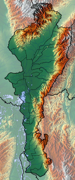 Topography of the department | |
| Coordinates: 10°29′N 73°15′W | |
| Country | |
| Region | Caribbean Region |
| Established | December 1967 |
| Capital | Valledupar |
| Government | |
| • Governor | Francisco Fernando Ovalle Angarita (2016-2019) |
| Area | |
| • Total | 22,905 km2 (8,844 sq mi) |
| • Rank | 22nd |
| Population (2018)[2] | |
| • Total | 1,200,574 |
| • Rank | 16th |
| • Density | 52/km2 (140/sq mi) |
| Time zone | UTC-05 |
| ISO 3166 code | CO-CES |
| HDI (2019) | 0.729[3] high · 21st of 33 |
| Website | www.gobcesar.gov.co |
The region was first inhabited by indigenous peoples known as Euparíes in the Valley of Upar and Guatapuríes in the Valley of the Cesar river, among these were the Orejones pertaining to the Tupe, Acanayutos pertaining to the Motilon and Alcoholados pertaining to the Chimila. The first European to explore the area was Spanish Captain Pedro de Vadillo, but German Ambrosio Alfínger savagely conquered the region in 1532.[5]
From 1996–2006 paramilitary groups committed gross human rights violations affecting tens of thousands of victims in the Cesar mining region.
Etymology
The "Cesar" name is an adaptation from the Chimila indigenous word Chet-tzar or Zazare ("calm water") into Spanish, in reference to the Cesar River. The valley that its basin covers is also named after the river and extends through most of the department. The department of Cesar was created in 1967 by decree and the name officially adopted.[6]
Geography

The department of Cesar is located in northern Colombia bordering to the north with the department of La Guajira, to the east with the Bolivarian Republic of Venezuela, to the west with the department of Magdalena, to the southwest with the Department of Bolivar and to the south with the departments of North Santander and Santander covering a total area of 22,905 km².[7]
The majority of the Department is flat in 57% of the total area and 43% mountainous mainly in the Serranía del Perijá and the Sierra Nevada de Santa Marta mountain ranges.[7]
Ecoregions
The Department of Cesar contains five Ecoregions; the Serranía del Perijá mountain range, the valley of the Cesar River, the Sierra Nevada de Santa Marta mountain range, the valley of the Magdalena River and the Cienaga de Zapatosa marshes complex.[7]

Serranía del Perijá mountain range
The Serranía del Perijá mountain range covers most of the eastern side of the Department of Cesar between its border with Venezuela and the Department of North Santander, approximately 300 km in length penetrating into the Department of La Guajira to the north and covering 27% of the total area of Cesar. The Serranía del Perijá covers, partially or totally the area of 17 municipalities in the Department of Cesar; Aguachica, Codazzi, Becerril, Chimichagua, Chiriguana, Curumani, Gonzalez, La Gloria, La Jagua de Ibirico, Los Robles La Paz, Manaure, Pailitas, Pelaya, Rio de Oro, San Alberto, San Diego and San Martin. There are also the indigenous reserves pertaining to the Yukpas people; Iroka, Socorpa and Menkue-Misaya-La Pista; and to the Wiwas people; Caño Padilla, El Rosario-Bella Vista-Yucatán and Campoalegre.[8]
Approximately 70% of the mountain range preserves unique flora and fauna and some 20 rivers are born in the mountain range among other minor streams, flowing into the Department of Cesar and feeding the Magdalena and Cesar river basins and the Cienaga de Zapatosa marshes. The Colombian government declared it a National Forest Reserve.[8]
Sierra Nevada de Santa Marta mountain range
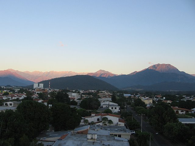
The Sierra Nevada de Santa Marta mountain range is an isolated mountain range located in the northwestern region of the Department of Cesar. The mountain range is shared with by Department of La Guajira, which covers the northern area, the Department of Magdalena to the western side and the Department of Cesar which covers the southern face, covering a total area of 16,615 km² (1'661,500 ha) of which 380,000 ha pertain to the Department of Cesar. The Cesar River and the western side of its basin is born on the Sierra Nevada de Santa Marta, including the Guatapuri, Badillo, Ariguani, Cesarito, Los Clavos, Garupal and Rio Seco rivers. The mountains are within the boundaries of the municipalities of Pueblo Bello, Valledupar, El Copey and Bosconia. [9]
The Sierra Nevada de Santa Marta was declared by UNESCO as a Biosphere Reserve on October 29, 1993.[10]
Valley of the Cesar river
Valley of the Magdalena river
Cienaga de Zapatosa marshes
Ciénaga de Zapatosa
Climate
Climate in the Department of Cesar presents variations in climate depending on altitude, as well as rainfall precipitations. Mountain climate in the Sierra Nevada de Santa Marta and the Serranía del Perijá become cooler with higher altitude, reaching freezing low temperatures on the snowy peaks. Lowlands average a temperature throughout the year of 28 °C or 82.4 °F.[11] These lower lands present a hot and drier climate, with annual precipitation less than 1,300 millimetres or 51 inches a year. The mountainous regions are characterized by low temperatures with snow on high altitude peaks and precipitation reaching more than 2,000 millimetres or 79 inches a year.
| Climate data for Valledupar | |||||||||||||
|---|---|---|---|---|---|---|---|---|---|---|---|---|---|
| Month | Jan | Feb | Mar | Apr | May | Jun | Jul | Aug | Sep | Oct | Nov | Dec | Year |
| Average high °C (°F) | 34.7 (94.5) |
35.6 (96.1) |
35.9 (96.6) |
35.6 (96.1) |
34.0 (93.2) |
34.2 (93.6) |
35.4 (95.7) |
35.1 (95.2) |
33.8 (92.8) |
32.6 (90.7) |
33.2 (91.8) |
33.6 (92.5) |
35.1 (93.6) |
| Average low °C (°F) | 22.4 (72.3) |
23.1 (73.6) |
23.6 (74.5) |
24.1 (75.4) |
24.1 (75.4) |
24.0 (75.2) |
24.2 (75.6) |
24.0 (75.2) |
23.5 (74.3) |
23.6 (74.5) |
23.1 (73.6) |
22.8 (73.0) |
23.6 (74.3) |
| Average rainfall mm (inches) | 12 (0.5) |
10 (0.4) |
26 (1.0) |
71 (2.8) |
154 (6.1) |
82 (3.2) |
63 (2.5) |
116 (4.6) |
122 (4.8) |
199 (7.8) |
89 (3.5) |
28 (1.1) |
972 (38.3) |
| Source: Weatherbase[12][13] | |||||||||||||
History
| Year | Pop. | ±% |
|---|---|---|
| 1973 | 340,657 | — |
| 1985 | 699,428 | +105.3% |
| 1993 | 827,219 | +18.3% |
| 2005 | 903,279 | +9.2% |
| 2018 | 1,200,574 | +32.9% |
| Source:[14] | ||
Pre-Columbian
The region was first inhabited by indigenous peoples known as Euparíes in the Valley of Upar and Guatapuríes in the Valley of the Cesar river, among these were the Orejones pertaining to the Tupe, Acanayutos pertaining to the Motilon and Alcoholados pertaining to the Chimila.
Spanish chronicles describe the tribes as being part of a federation of tribes led by a single chief (Cacique), with the village of Eupari as the largest and central to the other villages. These tribes are believed to be related to the Mesoamerican culture, the Caribs and Arawaks, directly associated to the Muisca culture in the Colombian eastern branch of the Andes.[15]
Archeological findings has shown that the indigenous in the area worked with stones and wood, including a boomerang shaped weapon found in a cemetery at Los Robles La Paz.[16]
Spanish conquest and colonization
The first European to explore the area was Spanish Captain Pedro de Vadillo, but German Ambrosio Alfínger savagely conquered the region in 1531.[5][17] In 1550 the village of Valle de Upar was founded by Hernando de Santana and Juan de Castellanos.<[18]
Republican era
In 1813, María de la Concepción Loperena proclaimed the independence of Valledupar and donated 300 horses to Simón Bolívar. In 1829 Valledupar became a Cantón of the Province of Santa Marta. By Law 15 of 1850, Valledupar was segregated from Santa Marta becoming the Province of Valledupar. In 1857 became a province of the State of Magdalena and by Law of December 29, 1864 became the Department of Valledupar pertaining to State of Magdalena. On December 21, 1967 the Department of Cesar was created officially.[5]
Modern era
From 1996–2006 paramilitary groups committed gross human rights violations affecting tens of thousands of victims in the Cesar mining region. Prodeco, a subsidiary of Glencore, and the US Drummond Company collaborated with the paramilitaries[19] in order to continue coal mining.[20]
Politics
Government and Politics
Governors
Department Assembly
Administrative divisions
Municipalities
The Department of Cesar is formed by 25 municipalities, some 171 corregimientos, 990 veredas and 10 indigenous reserves.[21]
For administrative reasons the Department of Cesar is subdivided into 4 strategic regions[citation needed]:
- the Northern Subregion covering the municipalities of Valledupar, Codazzi, Pueblo Bello, La Paz, Manaure and San Diego;
- the Northwestern Subregion covering the municipalities of Bosconia, El Copey, El Paso and Astrea;
- the Central Subregion covering the municipalities of Curumani, Becerril, Chiriguana, La Jagua de Ibirico, Chimichagua, Tamalameque and Pailitas; and
- the Southern Subregion covering the municipalities of Aguachica, Gamarra, Gonzalez, La Gloria, Pelaya, Rio de Oro, San Alberto and San Martin.[7]
| Municipalities | Map |
|---|---|
|
 |
Economy

The economy of the César Department is sustained by the agricultural sector, secondly by a services industry following with commercial industry and mining. Cattle raising is exploited extensively (using large farms), and for this reason large portions of forests have been chopped off to create corrals. In agriculture, plantations of cotton, rice, sugar cane, oil palm, cassava and plantain. Services are centered on commerce and the industry is represented by oil products, fats and milk derived products. As one of the biggest water resources areas of Colombia, if not America, part of the Magdalena River crosses the Department and helps create the Cienaga de Zapatosa (Zapatosa Marsh) along with the Cesar river. It has a great potential to develop a fishing industry also.
The area between La Loma and La Jagua de Ibirico is the major coal-producing region of Colombia.[22]
Notes
- "Departamento: Información general". Gobernación del Cesar. Archived from the original on 17 February 2013.
- "DANE". Archived from the original on November 13, 2009. Retrieved February 13, 2013.
- "Sub-national HDI - Area Database - Global Data Lab". hdi.globaldatalab.org. Retrieved 2018-09-13.
- "Estado de avance de los Objetivos de Desarrollo del Milenio en el departamento de Cesar y en la ciudad de Valledupar, (Progress on the Millennium Development Goals in the Cesar department and the city of Valledupar)" (in Spanish). PNUD Colombia – Fundación Universitaria del Área Andina. January 2012.[dead link]
- "History of Cesar" (in Spanish). Agustin Codazzi Geographic Institute. Archived from the original on 24 October 2003.
- (in Spanish) LABLAA - Luis Galvis: Don Gonzalo
- (in Spanish) Government of the Department of Cesar: The Territory Archived October 23, 2007, at the Wayback Machine
- (in Spanish) Government of the Department of Cesar: Serrania del Perija Archived March 27, 2009, at the Wayback Machine
- (in Spanish) Government of the Department of Cesar: Sierra Nevada de Santa Marta Archived March 27, 2009, at the Wayback Machine
- (in Spanish) UNESCO: Buritaca 200 - Ciudad Perdida - Sierra Nevada de Santa Marta
- "Climate of the Department of Cesar" (in Spanish). Agustin Codazzi Geographic Institute. Archived from the original on 24 October 2003.
- "Worldweather: Valledupar, Colombia". Weatherbase. 2008. Retrieved 2008-04-08.[dead link]
-
- Climatological information is based on monthly averages for the 30-year period 1971-2000. The averaging period for climatological information and the definition of "Mean Number of Precipitation/Rain Days" quoted in this web site may be different for different countries. Care should be taken when city climatologies are compared.
- "Reloj de Población". DANE. Departamento Administrativo Nacional de Estadísitica. Retrieved 6 July 2017.
- Castro Trespalacios 1979, p. 22
- Castro Trespalacios 1979, p. 23
- Castro Trespalacios 1979, p. 21
- LABLAA: Department of Cesar; History
- Moor, Marianne (June 2014). The dark side of coal paramilitary violence in the mining region of Cesar, Colombia. OCLC 1176254365. Retrieved 2022-04-28.
- Deutsche Welle (2014-07-09). "Blutige Kohle aus Kolumbien". DW.COM (in German). Retrieved 2022-04-28.
- Government of Colombia: Human Rights in the Department of Cesar; municipalities Archived May 29, 2008, at the Wayback Machine
- https://www.mining-atlas.com/operation/La-Loma-Coal-Mine.php
References
- Dangon Ovalle, Jaime (November 1987), El Cesar, Hijo del Amor, Valledupar: Departamento del Cesar.
- Gutierrez Hinojosa, Tomas Dario (2000), Valledupar Musica de una Historia, Bogotá: Editorial Grijalbo LTDA, ISBN 958-639-175-2
- Araujonoguera, Consuelo (2002), Trilogia Vallenata, Colombia: Proyecto Editorial Babilonia, ISBN 958-33-3360-3
- Castro Trespalacios, Pedro (1979), Culturas Aborigenes Cesarences e Independencia de Valle de Upar, Bogotá: Casa de la Cultura de Valledupar
External links
- Cesar 30 Años de Progreso - Gobernacion del Cesar (1997) booklet
- Official website
- INGEOMINAS: Geography of the Department of Cesar[permanent dead link]
- Poverty in the Department of Cesar
- Forced displacement in the Department of Cesar[permanent dead link]
Capital: Valledupar | |
| Geography |
|
| History |
|
| Government |
|
| Politics |
|
| Demography |
|
| Economy |
|
| Culture |
|
| Municipalities |
|
Departments of Colombia | ||
|---|---|---|
 | ||
| Authority control |
|
|---|
На других языках
[de] Departamento del Cesar
Das Departamento del Cesar ist ein Departamento im Nordosten Kolumbiens. Es grenzt im Osten an Venezuela und ist sonst umgeben von den Departamentos de La Guajira im Norden, Norte de Santander im Osten, Santander im Süden und Bolívar und Magdalena im Westen.- [en] Cesar Department
[ru] Сесар (департамент)
Сеса́р (исп. Cesar) — один из департаментов Колумбии, расположенный на севере страны в Карибском регионе. На севере граничит с Гуахирой, на западе с Магдаленой и Боливаром, на юге с Сантандером, на юго-востоке с Норте-де-Сантандером и на востоке с Венесуэлой (со штатом Сулия). Административный центр — город Вальедупар.Другой контент может иметь иную лицензию. Перед использованием материалов сайта WikiSort.org внимательно изучите правила лицензирования конкретных элементов наполнения сайта.
WikiSort.org - проект по пересортировке и дополнению контента Википедии