world.wikisort.org - Colombia
Bolívar (Spanish pronunciation: [boˈliβaɾ]) is a department of Colombia. It was named after one of the original nine states of the United States of Colombia. It is located to the north of the country, extending roughly north–south from the Caribbean coast at Cartagena near the mouth of the Magdalena River, then south along the river to a border with Antioquia Department. The departments of Sucre and Córdoba are located to the west, and Atlántico Department is to the north and east (most of the border formed by the Canal del Dique). Across the Magdalena River to the east is Magdalena Department. The flag of the department bears a resemblance to the flag of Lithuania.
Department of Bolívar
Departamento de Bolívar | |
|---|---|
Department | |
 Flag  Coat of arms | |
| Motto(s): Ab Ordine Libertas (Latin: From order comes freedom) | |
| Anthem: Himno de Bolívar | |
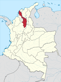 Bolívar shown in red | |
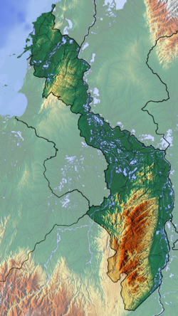 Topography of the department | |
| Coordinates: 10°24′N 75°30′W | |
| Country | |
| Region | Caribbean Region |
| Established | June 15, 1857 |
| Capital | Cartagena |
| Government | |
| • Governor | Vicente blel (2019-2023) |
| Area | |
| • Total | 25,978 km2 (10,030 sq mi) |
| • Rank | 14th |
| Population (2018)[3] | |
| • Total | 2,070,110 |
| • Rank | 7th |
| • Density | 80/km2 (210/sq mi) |
| Time zone | UTC-05 |
| ISO 3166 code | CO-BOL |
| Provinces | 6 |
| Municipalities | 46 |
| HDI (2019) | 0.756[4] high · 13th of 33 |
| Website | www.bolivar.gov.co |
Its capital is Cartagena. Other important cities include Magangué, El Carmen de Bolívar and Turbaco.
Provinces and Municipalities
Depresión Momposina
Dique
|
Loba
Magdalena Medio
|
Mojana
Montes de Maria
|
History
In today's villages of Maria La Baja, Sincerín, El Viso, and Mahates and Rotinet, excavations have uncovered the remains of maloka-type buildings, directly related to the early Puerto Hormiga settlements.[5]
| Year | Pop. | ±% |
|---|---|---|
| 1938 | 763,782 | — |
| 1951 | 924,082 | +21.0% |
| 1964 | 693,759 | −24.9% |
| 1973 | 817,838 | +17.9% |
| 1985 | 1,288,985 | +57.6% |
| 1993 | 1,702,188 | +32.1% |
| 2005 | 1,878,993 | +10.4% |
| 2018 | 2,070,110 | +10.2% |
| Source:[6] | ||
Miscellaneous
- Postage stamps of Bolívar
- List of Caribbean islands#Bolívar Department
References
- "Información Institucional: Geografía" (in Spanish). Gobernación del Bolivar. 2011. Archived from the original on 5 March 2012. Retrieved 17 March 2013.
- Kline, Harvey F. (2012). "Bolivar, Department of". Historical Dictionary of Colombia. Lanham, Maryland: Scarecrow Press. p. 83. ISBN 978-0-8108-7813-6.
- "DANE". Archived from the original on November 13, 2009. Retrieved February 13, 2013.
- "Sub-national HDI - Area Database - Global Data Lab". hdi.globaldatalab.org. Retrieved 2018-09-13.
- "Universidad del Norte". Uninorte.edu.co. Archived from the original on 2010-12-20. Retrieved 2010-06-24.
- "Reloj de Población". DANE. Departamento Administrativo Nacional de Estadísitica. Retrieved 6 July 2017.
External links
- View a boundary-overlaid version of Bolívar on Google Maps: http://www.maplandia.com/colombia/bolivar/turbana/
- Chisholm, Hugh, ed. (1911). . Encyclopædia Britannica. Vol. 4 (11th ed.). Cambridge University Press. p. 166.
Departments of Colombia | ||
|---|---|---|
 | ||
Authority control | |
|---|---|
| National libraries | |
| Other |
|
На других языках
[de] Departamento de Bolívar
Das Departamento de Bolívar ist ein kolumbianisches Departamento. Es befindet sich in der nördlichen Region des Landes, grenzt an das Karibische Meer und an den größten Strom Kolumbiens, den Río Magdalena. Der Wasserlauf stellt gleichzeitig die Grenze zu den Departamentos Magdalena, Santander und Cesar dar.- [en] Bolívar Department
[ru] Боливар (департамент)
Боли́вар (исп. Bolívar) — один из департаментов Колумбии. Располагается в северной части страны. На севере омывается Карибским морем. Административный центр — город Картахена[2].Другой контент может иметь иную лицензию. Перед использованием материалов сайта WikiSort.org внимательно изучите правила лицензирования конкретных элементов наполнения сайта.
WikiSort.org - проект по пересортировке и дополнению контента Википедии