world.wikisort.org - China
Ulanhot (Mongolian: ᠤᠯᠠᠭᠠᠨᠬᠣᠲᠠ; Chinese: 乌兰浩特), formerly known as Wangin Süm, alternatively Wang-un Süme, Ulaγanqota (Red City) in Classical Mongolian, is a county-level city and the administrative center of Hinggan League in the east of the Inner Mongolia autonomous region of China. Formerly known as Wangyehmiao or Wangyemiao (王爺廟), the city became the first capital of Inner Mongolia, the first autonomous region in China, on 1 May 1947,[2] until the regional capital moved to Zhangjiakou in late December 1949; the regional capital moved again in June 1952 to Hohhot, which remains the capital to this day.[3]
This article needs additional citations for verification. (July 2017) |
Ulanhot
乌兰浩特市 • ᠤᠯᠠᠭᠠᠨᠬᠣᠲᠠ | |
|---|---|
County-level city | |
 Ulanhot Airport main terminal building | |
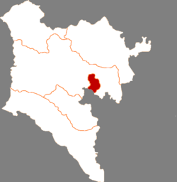 Ulanhot in Hinggan | |
 Ulanhot Location of the city center in Inner Mongolia | |
| Coordinates (Ulanhot municipal government): 46°04′20″N 122°05′36″E | |
| Country | People's Republic of China |
| Autonomous region | Inner Mongolia |
| League | Hinggan League |
| Area | |
| • County-level city | 772.0 km2 (298.1 sq mi) |
| • Urban | 86.10 km2 (33.24 sq mi) |
| Population (2017) | |
| • County-level city | 344,000 |
| • Density | 450/km2 (1,200/sq mi) |
| • Urban | 265,600 |
| Time zone | UTC+8 (China Standard) |
| Postal code | 137400 |
| Area code | 0482 |
| Website | www |
| Ulanhot | |||||||
|---|---|---|---|---|---|---|---|
| Chinese name | |||||||
| Simplified Chinese | 乌兰浩特 | ||||||
| Traditional Chinese | 烏蘭浩特 | ||||||
| |||||||
| Mongolian name | |||||||
| Mongolian Cyrillic | Улаан хот | ||||||
| Mongolian script | ᠤᠯᠠᠭᠠᠨᠬᠣᠲᠠ | ||||||
| |||||||
| Former name | |||||||
|---|---|---|---|---|---|---|---|
| Alternative Chinese name | |||||||
| Traditional Chinese | 王爺廟 | ||||||
| Simplified Chinese | 王爷庙 | ||||||
| Literal meaning | prince temple | ||||||
| |||||||
The city is connected to Baicheng, Jilin by the Baicheng–Arxan railway (Chinese: 白阿铁路), which runs through the pass south of Ulanhot[citation needed]. China's National Highway 302 runs from Tumen, Jilin to Ulanhot. In the 7918 Network of Highways it will be on the route from Hunchun to Ulanhot [clarification needed]. The city is also served by Ulanhot Yilelite Airport (ICAO code ZBUL, IATA code HLH). Routes flown by Air China and Hainan Airlines connect Ulanhot with Beijing Capital International Airport and Hohhot.
Just outside the city is a tomb from the Yuan dynasty and a temple dedicated to Genghis Khan. The temple was constructed in 1940. In the year 2002 it received funds for significant expansion.[4]
Climate
Ulan Hot has a monsoon-influenced humid continental climate (Köppen Dwa). Winters are long, cold and dry, while summers are very warm. The monthly 24-hour mean temperature ranges from −15.0 °C (5.0 °F) in January to 22.9 °C (73.2 °F) in July, and the annual mean is 5.03 °C (41.1 °F). Over two-thirds of the annual rainfall occurs from May to August.
| Climate data for Ulan Hot | |||||||||||||
|---|---|---|---|---|---|---|---|---|---|---|---|---|---|
| Month | Jan | Feb | Mar | Apr | May | Jun | Jul | Aug | Sep | Oct | Nov | Dec | Year |
| Record high °C (°F) | 6.0 (42.8) |
11.7 (53.1) |
23.5 (74.3) |
31.7 (89.1) |
38.3 (100.9) |
40.3 (104.5) |
39.7 (103.5) |
37.1 (98.8) |
32.5 (90.5) |
29.9 (85.8) |
18.9 (66.0) |
7.7 (45.9) |
40.3 (104.5) |
| Average high °C (°F) | −8.6 (16.5) |
−4.0 (24.8) |
3.8 (38.8) |
14.3 (57.7) |
22.2 (72.0) |
26.5 (79.7) |
28.1 (82.6) |
26.9 (80.4) |
21.3 (70.3) |
12.6 (54.7) |
1.2 (34.2) |
−6.5 (20.3) |
11.5 (52.7) |
| Daily mean °C (°F) | −15.0 (5.0) |
−11.1 (12.0) |
−3.0 (26.6) |
7.2 (45.0) |
15.2 (59.4) |
20.4 (68.7) |
22.9 (73.2) |
21.0 (69.8) |
14.4 (57.9) |
5.6 (42.1) |
−4.9 (23.2) |
−12.4 (9.7) |
5.0 (41.1) |
| Average low °C (°F) | −20.3 (−4.5) |
−17.1 (1.2) |
−9.6 (14.7) |
0.0 (32.0) |
7.7 (45.9) |
14.3 (57.7) |
17.8 (64.0) |
15.4 (59.7) |
8.0 (46.4) |
−0.4 (31.3) |
−9.9 (14.2) |
−17.2 (1.0) |
−0.9 (30.3) |
| Record low °C (°F) | −33.7 (−28.7) |
−31.2 (−24.2) |
−25.4 (−13.7) |
−13.6 (7.5) |
−4.5 (23.9) |
2.9 (37.2) |
10.4 (50.7) |
6.0 (42.8) |
−3.5 (25.7) |
−17.4 (0.7) |
−26.4 (−15.5) |
−32.9 (−27.2) |
−33.7 (−28.7) |
| Average precipitation mm (inches) | 1.3 (0.05) |
2.3 (0.09) |
4.8 (0.19) |
14.8 (0.58) |
28.8 (1.13) |
93.4 (3.68) |
148.6 (5.85) |
89.4 (3.52) |
37.3 (1.47) |
16.8 (0.66) |
3.2 (0.13) |
1.9 (0.07) |
442.6 (17.42) |
| Average precipitation days (≥ 0.1 mm) | 1.6 | 2.5 | 3.2 | 3.9 | 6.8 | 12.3 | 13.8 | 10.9 | 7.9 | 3.9 | 2.7 | 2.6 | 72.1 |
| Source: Weather China | |||||||||||||
References
- Ministry of Housing and Urban-Rural Development, ed. (2019). China Urban Construction Statistical Yearbook 2017. Beijing: China Statistics Press. p. 48. Retrieved 11 January 2020.
- Wang, Zhanyi (王占义); Shi, Ye (史叶) (2017-07-06). 1947年内蒙古自治政府在兴安盟成立-中国社会科学网. Chinese Academy of Social Sciences. Retrieved 2020-05-12.
- 内蒙古统一的民族区域自治的实现. Xinhua Inner Mongolia. Retrieved 2020-05-12.
- "China Plans New Investment to Expand Genghis Khan Temple". People's Daily. 2002-09-04.
Authority control | |
|---|---|
| General |
|
| National libraries | |
На других языках
- [en] Ulanhot
[ru] Улан-Хото
Улан-Хото (монг. , Ulaγanqota, красный город; кит. упр. 乌兰浩特, пиньинь Wūlánhàotè) — городской уезд аймака Хинган автономного района Внутренняя Монголия (КНР). Здесь размещается правительство аймака.Другой контент может иметь иную лицензию. Перед использованием материалов сайта WikiSort.org внимательно изучите правила лицензирования конкретных элементов наполнения сайта.
WikiSort.org - проект по пересортировке и дополнению контента Википедии