world.wikisort.org - China
Ejin or Ejina (Mongolian: ᠡᠵᠡᠨᠡ ᠬᠣᠰᠢᠭᠤ Эжэн-э қосиу Ejen-e qosiɣu; simplified Chinese: 额济纳; traditional Chinese: 額濟納; pinyin: Éjǐnà) is a banner in the far west of Inner Mongolia, China. It is under the administration of Alxa League and is the westernmost county-level division of Inner Mongolia, bordering Gansu province to the west and the Republic of Mongolia's Bayankhongor and Govi-Altai Provinces. Its seat is located at Dalaihob Town (达来呼布镇). To the west, it shares a border with Subei Mongol Autonomous County of Jiuquan, Gansu.
Ejin Banner
额济纳旗 • ᠡᠵᠡᠨᠡᠬᠣᠰᠢᠭᠤ | |
|---|---|
Banner | |
 Juyan Lake Wetland Park | |
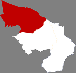 Location in Alxa | |
 Ejin Location of the seat in Inner Mongolia | |
| Coordinates: 41.7456°N 100.318°E | |
| Country | People's Republic of China |
| Autonomous region | Inner Mongolia |
| League | Alxa |
| Seat | Dalaihob (达来呼布镇) |
| Area | |
| • Total | 114,606 km2 (44,250 sq mi) |
| Population (2020)[1] | |
| • Total | 35,756 |
| • Density | 0.31/km2 (0.81/sq mi) |
| Time zone | UTC+8 (China Standard) |
| Area code | 0483 |
History
The area has historically been the hunting grounds of the Xiongnu before it was acquired by Han Dynasty in BC 121. The ancient city of Khara-Khoto, founded by the Western Xia, is located here.
The area was incorporated into the Mongol empire under Genghis Khan in 1226. During the Yuan Dynasty, the area was home to nomadic Mongol populations. It was later incorporated into the Qing Dynasty (1644–1912). Under the Republic of China, the area was under the jurisdiction of Ningxia province. The area fell under the control of the Communist Party in September 1949. Subsequently, it was placed successively under government commissions in Jiuquan, Zhangye, and Ningxia province.
On June 1, 1956, Ejin became part of the Bayannur League of the Inner Mongolia Autonomous Region. The Jiuquan Satellite Launch Center was constructed at around the same time. On May 1, 1980, it became part of the Alxa League. Since Chinese economic reforms in the 1980s, Ejin rapidly developed its economy. By the early 21st century it became one of the fastest-growing counties in the country measured by GDP.[citation needed]
Geography
Ejin Banner is the westernmost banner of Inner Mongolia. It is located in the Gobi Desert and borders on Mongolia in the north, Gansu Province in the southwest, and Alxa Right Banner in the southeast.
Ejin Banner is geographically vast - approximately the size of South Korea, it covers an area larger than the provinces of Jiangsu and Zhejiang.
Ejin Banner takes its name from the Ejin River, also known as Ruo Shui, which flows from the Qilian Mountains of Gansu, and whose two distributaries terminate in Juyan Lake Basin within Ejin banner. Most of the banner's population resides in this river's valley.
Transportation
Ejin Banner is served by the Ejin Banner Taolai Airport.
Train transportation is provided by Jiayuguan–Ceke and the Linhe–Ceke railways, which are primarily used to haul coal that has been trucked from Nariin Sukhait mining complex in Mongolia to Ceke and is loaded on trains at the coal terminals there. Passenger service exists on this railway; as of 2015 there is daily passenger service between Ejin and the regional capital Hohhot, which takes approximately 16 hours.[2]
There is also a railway south to both sites (northern and southern) of Jiuquan Satellite Launch Center, which are also located within Ejin Banner.
See also
- Khara-Khoto
- Jiuquan Satellite Launch Center
- Juyan Lake Basin
References
External links
- Ejin Banner Government Website (in Chinese)
Authority control | |
|---|---|
| General | |
| National libraries | |
| Other |
|
На других языках
- [en] Ejin Banner
[ru] Эдзин-Ци
Эдзин-Ци[1] (монг. Эзнээ хошуу, .mw-parser-output .font-mong{font-family:"Menk Ujug Tig","Menk Hawang Tig","Menk Qagan Tig","Menk Garqag Tig","Menk Har_a Tig","Menk Scnin Tig","Oyun Gurban Ulus Tig","Oyun Qagan Tig","Oyun Garqag Tig","Oyun Har_a Tig","Oyun Scnin Tig","Oyun Agula Tig","Mongolian Baiti","Noto Sans Mongolian","Mongolian Universal White","Mongol Usug","Mongolian White","MongolianScript","Code2000","Menksoft Qagan"}.mw-parser-output .font-mong-mnc,.mw-parser-output .font-mong:lang(mnc-Mong),.mw-parser-output .font-mong:lang(dta-Mong),.mw-parser-output .font-mong:lang(sjo-Mong){font-family:"Abkai Xanyan","Abkai Xanyan LA","Abkai Xanyan VT","Abkai Xanyan XX","Abkai Xanyan SC","Abkai Buleku","Daicing White","Mongolian Baiti","Noto Sans Mongolian","Mongolian Universal White"}.mw-parser-output .font-mong:lang(xal-Mong){font-family:"Mongolian Baiti","Noto Sans Mongolian","Mongolian Universal White"}ᠡᠵᠡᠨᠡᠬᠤᠰᠢᠭᠤ, кит. упр. 额济纳旗, пиньинь Éjìnà-qí, палл. Эцзина-ци) — хошун в аймаке Алашань автономного района Внутренняя Монголия (КНР). Название хошуна в переводе с тангутского языка означает «Чёрная вода».Другой контент может иметь иную лицензию. Перед использованием материалов сайта WikiSort.org внимательно изучите правила лицензирования конкретных элементов наполнения сайта.
WikiSort.org - проект по пересортировке и дополнению контента Википедии