world.wikisort.org - China
Dorbod (Siziwang) Banner (Mongolian: ᠳᠥᠷᠪᠡᠳ ᠬᠣᠰᠢᠭᠤ Dörbed qosiɣu, Дөрвөд хошуу, Dörwöd hoşú; Chinese: 四子王旗; pinyin: Sìzǐwáng Qí) is a banner (county equivalent) in Ulanqab, Inner Mongolia, China,[1] bordering Mongolia's Dornogovi Province to the northwest. It is located about 80 km (50 mi) north of Hohhot, the capital of Inner Mongolia.
Dorbod Banner
四子王旗 · ᠳᠥᠷᠪᠡᠳ ᠬᠣᠰᠢᠭᠤ | |
|---|---|
Banner | |
 | |
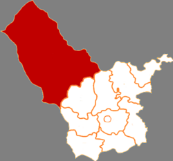 Dorbod in Ulanqab | |
 Ulanqab in Inner Mongolia | |
| Coordinates: 41°31′59″N 111°42′24″E | |
| Country | People's Republic of China |
| Province | Inner Mongolia |
| Prefecture-level city | Ulanqab |
| Area | |
| • Total | 25,513 km2 (9,851 sq mi) |
| Population (2020) | |
| • Total | 129,372 |
| • Density | 5.1/km2 (13/sq mi) |
| Time zone | UTC+8 (China Standard) |
The banner spans 25,513 square kilometres (9,851 sq mi), and has a population of 129,372 as of 2020.[2] Its seat of government is located in Wulanhua.[3]
Toponymy
The Chinese name for the banner siziwang, literally "four princes", derives from the area's historic rule by four brothers.[2] The Mongolian name for the banner dorbed means "of four".[citation needed]
History

The area of Dorbod Banner was ruled by four Mongol brothers, Sengge (Chinese: 僧格), Suonuobu (Chinese: 索諾布), Emubu (Chinese: 鄂木布) and Yi'erzhamu (Chinese: 伊爾扎木), who were descendants of Hasar, a brother of Genghis Khan.[citation needed] They led their tribe in participating in the Manchu Qing Dynasty's conquest of Ming China in the early 17th century.[citation needed] In recognition of their service, the Qing court made Emubu the Duoluo Commandery Prince (Chinese: 多羅郡王) in 1649 and settled their tribe in the area of modern Siziwang Banner.[citation needed] The title was hereditary and passed through fourteen of his descendants before the Communist Party of China abolished all hereditary titles in Inner Mongolia in 1949.[citation needed] The last prince, Sudanamuchaogeji (Chinese: 蘇達那木朝格吉), died as a private citizen in 1957.[citation needed] There is a sculpture of the four original princes in Wulanhua, erected in 2003.
Geography
To its east lies Sonid Right Banner, Qahar Right Rear Banner, and Qahar Right Middle Banner.[3] To its south lies Wuchuan County and Zhuozi County.[3] To its west lies Darhan Muminggan United Banner.[3] Its north is formed by a 104 kilometres (65 mi) border with Mongolia.[3]
Its seat of government, the town of Wulanhua, is located 105 kilometres (65 mi) away from Hohhot, and 270 kilometres (170 mi) away from Erlianhot.[3]
The banner is located along the northern foothills of the Yin Mountains, and has an average elevation of 1,400 metres (4,600 ft).[3] Most of the banner's area is grassland.[3]
Climate
The banner experiences an average of 250 millimetres (9.8 in) to 300 millimetres (12 in) of precipitation annually.[3] Its average annual temperature is 3 °C (37 °F).[3]
Administrative divisions
Dorbod Banner is divided into five towns, three townships, five sums, and one other township-level division.[4]
The banner's five towns are Wulanhua, Jishengtai, Kuluntu, Gongjitang, and Baiyinchaoketu.[4]
The banner's three townships are Dongbahao Township, Hujitu Township, and Daheihe Township.[4]
The banner's five sums are Honggor Sum, Jiang'an Sum, Chaganbulige Sum, Naomugeng Sum, and Bayin'aobao Sumu.[4]
The banner is also home to Wulan Ranch.[4]
Demographics
As of 2009, the banner is home to 216,990 people, up from the 180,568 reported in the 2000 Census.[2]
The banner's ethnic minorities include 18,902 Mongols (8.71% of the total population), 1,086 Manchus (0.50%), and 837 Hui people (0.39%).[2]
Economy
Mineral deposits in the banner include gold, copper, nickel, manganese, fluorite, gypsum, coal, and thenardite.[3]
Spacecraft landing site
The banner served as the landing sites for China's Shenzhou program.[5]
A pasture known as Amugulang, located in Honggor Sum, about 60 km (37 mi) north of Wulanhua, served as the landing site for the Shenzhou-6 spacecraft.[6] A specially constructed 64.69 km (40.20 mi) road runs from Wulanhua to Honggor to aid the recovery of the Shenzhou spacecraft, and to boost the local economy.[6] This road shortened the journey between the two towns from two hours to just 40 minutes.[6]
Chinese space program recovery teams (with SUV and recovery trucks) track the progress of re-entry near the landing site and arrive shortly after landing.[7]
A small recovery trucks fitted with a crane lifts the capsule and places it on the rear of the truck for transportation back to the space centre.[citation needed]
Since the final landing of Shenzhou 11 in Dorbod Banner in 2016, new facilities have been built to hasten the retrieval process for various spacecraft.[citation needed]
In December 2020, the Chang'e 5 spacecraft landed in Dorbod Banner following a successful collection of Moon rocks.[5]
See also
- Chinese space program
Notes
- ^ — All of the names presented here are transcribed from Chinese language sources using Hanyu Pinyin into the Roman alphabet. However, as these names are Mongolian and/or Manchu in origin, it would be much more accurate to transcribe them directly from those languages. These transcriptions are, however, unavailable as of now.
References
Citations
- 2020年统计用区划代码(乌兰察布市) (in Chinese). National Bureau of Statistics of China. 2020. Archived from the original on 2020-12-17. Retrieved 2020-12-17.
- 四子王旗历史沿革. xzqh.org (in Chinese). 2013-04-16. Archived from the original on 2020-12-17. Retrieved 2020-12-17.
- 四子王旗概况地图. xzqh.org (in Chinese). 2013-04-16. Archived from the original on 2020-12-17. Retrieved 2020-12-17.
- 2020年统计用区划代码(四子王旗) (in Chinese). National Bureau of Statistics of China. 2020. Archived from the original on 2020-12-17. Retrieved 2020-12-17.
- "Chinese Capsule Returns to Earth Carrying Moon Rocks". Time. 2020-12-16. Archived from the original on 2020-12-17. Retrieved 2020-12-17.
- "People's Daily Online -- Primary landing site ready to greet Chinese taikonauts back home". people.cn. 2005-10-15. Archived from the original on 2020-12-18. Retrieved 2020-12-18.
- Shenzhou 5 Archived 2011-06-28 at the Wayback Machine
News
- "Primary landing site ready to greet taikonauts back". Xinhua News Agency. 2005-10-14. Archived from the original on May 14, 2011.
На других языках
- [en] Dorbod Banner
[ru] Сыцзыван
Хошун Сыцзыва́н (кит. упр. 四子王旗, пиньинь Sìzǐwáng qí) — хошун городского округа Уланчаб автономного района Внутренняя Монголия (КНР). Название хошуна в переводе с китайского означает «Четыре княжича».Другой контент может иметь иную лицензию. Перед использованием материалов сайта WikiSort.org внимательно изучите правила лицензирования конкретных элементов наполнения сайта.
WikiSort.org - проект по пересортировке и дополнению контента Википедии