world.wikisort.org - China
Hanggin Rear Banner (Mongolian script: ᠬᠠᠩᠭᠢᠨ ᠬᠣᠶᠢᠲᠤ ᠬᠣᠰᠢᠭᠤ; Chinese: 杭锦后旗) is a banner in the west of the Inner Mongolia Autonomous Region, China. It has an area of 1,767 km2 (682 sq mi) and 217,573 inhabitants (2020). Its administrative center is the town of Shanba (Shenpa) (陕坝镇).
Hanggin Rear Banner
杭锦后旗 • ᠬᠠᠩᠭᠢᠨ ᠬᠣᠶᠢᠲᠤ ᠬᠣᠰᠢᠭᠤ | |
|---|---|
Banner | |
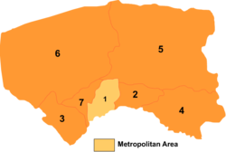 Bayannur divisions: Hanggin Rear Banner is 7 on this map | |
 Hanggin HQ Location of the seat in Inner Mongolia | |
| Coordinates: 40°49′45″N 107°00′47″E | |
| Country | People's Republic of China |
| Autonomous region | Inner Mongolia |
| Prefecture-level city | Bayannur |
| Area | |
| • Total | 1,791 km2 (692 sq mi) |
| Population (2020)[1] | |
| • Total | 217,573 |
| • Density | 120/km2 (310/sq mi) |
| Time zone | UTC+8 (China Standard) |
| Hanggin Rear Banner | |||||||||||
|---|---|---|---|---|---|---|---|---|---|---|---|
| Chinese name | |||||||||||
| Simplified Chinese | 杭锦后旗 | ||||||||||
| Traditional Chinese | 杭錦後旗 | ||||||||||
| |||||||||||
| Mongolian name | |||||||||||
| Mongolian Cyrillic | Қанин Қоыиту қосиу | ||||||||||
| Mongolian script | ᠬᠠᠩᠭᠢᠨ ᠬᠣᠶᠢᠲᠤ ᠬᠣᠰᠢᠭᠤ | ||||||||||
| |||||||||||
Transportation
Hanggin Rear Banner is served by the Linhe-Ceke Railway.
References
External links
This Inner Mongolia location article is a stub. You can help Wikipedia by expanding it. |
На других языках
- [en] Hanggin Rear Banner
[ru] Хангин-Хоуци
Хангин-Хоуци (кит. упр. 杭锦后旗, пиньинь Hángjǐn Hòu qí) — хошун городского округа Баян-Нур, Внутренней Монголии, в Китае. Название хошуна означает «Хангинское тыловое знамя»; он так называется потому, что лежит севернее хошуна Хангин городского округа Ордос.Текст в блоке "Читать" взят с сайта "Википедия" и доступен по лицензии Creative Commons Attribution-ShareAlike; в отдельных случаях могут действовать дополнительные условия.
Другой контент может иметь иную лицензию. Перед использованием материалов сайта WikiSort.org внимательно изучите правила лицензирования конкретных элементов наполнения сайта.
Другой контент может иметь иную лицензию. Перед использованием материалов сайта WikiSort.org внимательно изучите правила лицензирования конкретных элементов наполнения сайта.
2019-2026
WikiSort.org - проект по пересортировке и дополнению контента Википедии
WikiSort.org - проект по пересортировке и дополнению контента Википедии