world.wikisort.org - China
Horqin Left Rear Banner (Mongolian: ᠬᠣᠷᠴᠢᠨ ᠵᠡᠭᠦᠨ ᠭᠠᠷᠤᠨ ᠬᠣᠶᠢᠲᠤ ᠬᠣᠰᠢᠭᠤ [note 1] ; Chinese: 科尔沁左翼后旗, original Mongolian name Büve vang qosigu[citation needed]) is a banner of southeastern Inner Mongolia, People's Republic of China, bordering Liaoning province to the south. It is under the administration of Tongliao City, 75 kilometres (47 mi) to the north and its banner seat is the town of Ganjig (ᠭᠠᠨᠵᠤᠭᠠ
ᠪᠠᠯᠭᠠᠰᠤ, Ganjig Balgas; 甘旗卡镇, Ganqika Zhen). The local Mongolian dialect is Khorchin Mongolian.
Horqin Left Rear Banner
科尔沁左翼后旗 • ᠬᠣᠷᠴᠢᠨᠵᠡᠭᠦᠨᠭᠠᠷᠤᠨᠬᠣᠶᠢᠲᠤᠬᠣᠰᠢᠭᠤ | |
|---|---|
Banner | |
 Grasslands near Agula Town | |
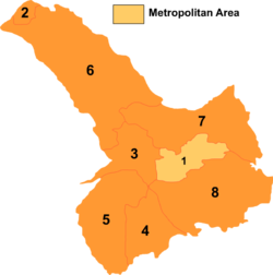 Tongliao divisions: Horqin Left Rear Banner is 8 on this map | |
 Horqin LBB Location of the seat in Inner Mongolia | |
| Coordinates: 42°57′N 122°21′E | |
| Country | People's Republic of China |
| Region | Inner Mongolia |
| Prefecture-level city | Tongliao |
| Area | |
| • Total | 11,500 km2 (4,400 sq mi) |
| Elevation | 250 m (820 ft) |
| Population (2020)[1] | |
| • Total | 321,438 |
| • Density | 28/km2 (72/sq mi) |
| Time zone | UTC+8 (China Standard) |
| Horqin Left Rear Banner | |||||||
|---|---|---|---|---|---|---|---|
| Chinese name | |||||||
| Simplified Chinese | 科尔沁左翼后旗 | ||||||
| Traditional Chinese | 科爾沁左翼後旗 | ||||||
| |||||||
| Mongolian name | |||||||
| Mongolian Cyrillic | Хорчин зүүн гарын хойд хошуу | ||||||
| Mongolian script | ᠬᠣᠷᠴᠢᠨᠵᠡᠭᠦᠨᠭᠠᠷᠤᠨᠬᠣᠶᠢᠲᠤᠬᠣᠰᠢᠭᠤ | ||||||
| |||||||
Notes
- Transliteration: Qorčin Jegün Ɣarun Qoyitu Qosiɣu
References
External links
- www.xzqh.org (in Chinese)
Authority control | |
|---|---|
| General | |
| National libraries | |
This Inner Mongolia location article is a stub. You can help Wikipedia by expanding it. |
На других языках
[de] Hinteres Horqin-Banner des Linken Flügels
Das Hintere Horqin-Banner des Linken Flügels (chinesisch .mw-parser-output .Hani{font-size:110%}科尔沁左翼后旗, Pinyin Kē'ěrqìn Zuǒyì Hòu Qí; mongolisch ᠬᠣᠷᠴᠢᠨ ᠵᠡᠭᠦᠨ ᠭᠠᠷᠤᠨ ᠬᠣᠶᠢᠲᠤ ᠬᠣᠰᠢᠭᠤ Qorčin Jegün Ɣarun Qoyitu qosiɣu) ist ein Banner der bezirksfreien Stadt Tongliao im Osten des Autonomen Gebietes Innere Mongolei im Nordosten der Volksrepublik China. Es hat eine Fläche von 11.476 km² und zählt 400.000 Einwohner (2000). Sein Hauptort ist die Großgemeinde Ganjag (甘旗卡镇).- [en] Horqin Left Rear Banner
[ru] Хорчин-Цзоихоуци
Хорчин-Цзоихоуци (кит. упр. 科尔沁左翼后旗, пиньинь Kē'ěrqìn Zuǒyì Hòuqí) или сокращённо Кэцзохоу-Ци (кит. упр. 科左后旗, пиньинь KēZuǒHòuqí) — хошун городского округа Тунляо автономного района Внутренняя Монголия (КНР). Название в переводе означает «Тыльное знамя левого крыла хорчинов».Текст в блоке "Читать" взят с сайта "Википедия" и доступен по лицензии Creative Commons Attribution-ShareAlike; в отдельных случаях могут действовать дополнительные условия.
Другой контент может иметь иную лицензию. Перед использованием материалов сайта WikiSort.org внимательно изучите правила лицензирования конкретных элементов наполнения сайта.
Другой контент может иметь иную лицензию. Перед использованием материалов сайта WikiSort.org внимательно изучите правила лицензирования конкретных элементов наполнения сайта.
2019-2026
WikiSort.org - проект по пересортировке и дополнению контента Википедии
WikiSort.org - проект по пересортировке и дополнению контента Википедии