world.wikisort.org - Afghanistan
Khani Chahar Bagh is the most northerly district in Faryab Province. The main village, Chahar Bagh 37.0444°N 65.2308°E, is in the southern part of the district. In the north the district's border is with Turkmenistan. The population in 2013 was estimated at 70,000. Ethnic composition includes 35% Turkmen and 65% Uzbek.[5]
Khani Chahar Bagh
خان چارباغ | |
|---|---|
District | |
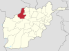
 Khani Chahar Bagh Location within Afghanistan[2] | |
| Coordinates: 37°07′N 65°14′E | |
| Country | |
| Province | Faryab |
| Area | |
| • Total | 1,056 km2 (408 sq mi) |
| Elevation | 278 m (912 ft) |
| Population (2013)[4] | |
| • Total | 70,000 |
References
-
Languages(Turkmen)(Uzbek)
- "District Names". National Democratic Institute. Archived from the original on 29 January 2016. Retrieved 30 September 2015.
- Afghanistan Geographic & Thematic Layers
- "Faryab Province". Government of Afghanistan and United Nations Development Programme (UNDP). Ministry of Rural Rehabilitation and Development. Archived from the original on 14 April 2013. Retrieved 22 October 2012.
- Khan Charbagh District (Re-elected)
External links
- District Profile UNHCR, July 2002
- Map of Settlements IMMAP, 2011
Capital: Maymana | ||
| Districts |
|  |
| Populated places | ||
| Other |
| |
This Faryab Province, Afghanistan location article is a stub. You can help Wikipedia by expanding it. |
Текст в блоке "Читать" взят с сайта "Википедия" и доступен по лицензии Creative Commons Attribution-ShareAlike; в отдельных случаях могут действовать дополнительные условия.
Другой контент может иметь иную лицензию. Перед использованием материалов сайта WikiSort.org внимательно изучите правила лицензирования конкретных элементов наполнения сайта.
Другой контент может иметь иную лицензию. Перед использованием материалов сайта WikiSort.org внимательно изучите правила лицензирования конкретных элементов наполнения сайта.
2019-2026
WikiSort.org - проект по пересортировке и дополнению контента Википедии
WikiSort.org - проект по пересортировке и дополнению контента Википедии