world.wikisort.org - Afghanistan
Bamyan Province (Dari: ولایت بامیان) also spelled Bamiyan, Bāmīān or Bāmyān[5] is one of the thirty-four provinces of Afghanistan, located in the central highlands of the Afghanistan.
Bamyan
بامیان | |
|---|---|
Province | |
 Various places in Bamyan province | |
 The location of Bamiyan province within Afghanistan | |
| Coordinates (Capital): 34.75°N 67.25°E | |
| Country | |
| Capital | Bamyan |
| Government | |
| • Governor | Abdullah Sarhadi[1] |
| • Deputy Governor | Atiqullah Atiq[2] |
| Area | |
| • Total | 18,029.2 km2 (6,961.1 sq mi) |
| Population (2021)[4] | |
| • Total | 504,312 |
| • Density | 28/km2 (72/sq mi) |
| Time zone | UTC+4:30 (Afghanistan Time) |
| ISO 3166 code | AF-BAM |
| Main languages | Dari (Hazaragi dialect) |
The terrain in Bamyan is mountainous or semi-mountainous, at the western end of the Hindu Kush mountains concurrent with the Himalayas. The province is divided into eight districts, with the town of Bamyan serving as its capital. The province has a population of about 495,557[6] and borders Samangan to the north, Baghlan, Parwan and Wardak to the east, Ghazni and Daykundi to the south, and Ghor and Sar-e Pol to the west. It is the largest province in the Hazarajat region of Afghanistan and is the cultural capital of the Hazara ethnic group that predominates in the area.
It was a center of commerce and Buddhism in the 4th and 5th centuries.[5] In antiquity, central Afghanistan was strategically placed to thrive from the Silk Road caravans that crisscrossed the region, trading between the Roman Empire, China, Central Asia, and South Asia. Bamyan was a stopping-off point for many travelers. It was here that elements of Greek and Buddhist art were combined into a unique classical style known as Greco-Buddhist art.
The province has several famous historical sites, including the now-destroyed Buddhas of Bamiyan, around which are more than 3,000 caves, the Band-e Amir National Park, Dara-i-Ajhdar, Gholghola and Zakhak ancient towns, the Feroz Bahar, Astopa, Klegan, Gaohargin, Kaferan and Cheldukhtaran.
History
Ancient
Archaeological exploration done in the 20th century suggests that the geographical area of Afghanistan has been closely connected by culture and trade with its neighbors to the east, west, and north. Artifacts typical of the Paleolithic, Mesolithic, Neolithic, Bronze, and Iron Ages have been found in Afghanistan.[7] Urban civilization is believed to have begun as early as 3000 BC, and the early city of Mundigak (near Kandahar in the south of the country) may have been a colony of the nearby Indus Valley civilization.[8]
After 2000 BC, successive waves of semi-nomadic people from Central Asia began moving south into Afghanistan; among them were many Indo-European-speaking Indo-Iranians.[9] These tribes later migrated further south to India, west to what is now Iran, and towards Europe via the area north of the Caspian Sea.[10] The region as a whole was called Ariana.[9][11][12]

The people shared similar culture with other Indo-Iranians. The ancient religion of Kafiristan survived here until the 19th century. Another religion, Zoroastrianism is believed by some to have originated in what is now Afghanistan between 1800 and 800 BC, as its founder Zoroaster is thought to have lived and died in Balkh.[13][14][15] Ancient Eastern Iranian languages may have been spoken in the region around the time of the rise of Zoroastrianism.
By the middle of the 6th century BC, the Achaemenid Persians overthrew the Medes and incorporated Arachosia, Aria, and Bactria within its eastern boundaries. An inscription on the tombstone of King Darius I of Persia mentions the Kabul Valley in a list of the 29 countries that he had conquered.[16]
In 330 BC, Alexander the Great seized the area but left it to the Seleucids to rule.

Afghanistan's significant ancient tangible and intangible Buddhist heritage is recorded through wide-ranging archeological finds, including religious and artistic remnants. Buddhist doctrines are reported to have reached as far as Balkh even during the life of the Buddha (563 BC to 483 BC), as recorded by Husang Tsang. It became the site of an early Buddhist monastery. "Buddhism was by this time in an expansionist mode, offering religious practices that spoke to the masses and an appealing style of illustrative art, backed by the subtle philosophy of the Mahayana sect" [17] Many statues of Buddha were carved into the sides of cliffs facing Bamyan city. The two most prominent of these statues were standing Buddhas, now known as the Buddhas of Bamyan, measuring 53 and 40 meters high respectively, which were the largest examples of standing Buddha carvings in the world. They were probably erected in the 4th or 5th century A.D. They were cultural landmarks for many years and are listed among UNESCO's World Heritage Sites. In March 2001 the Taliban government decreed that the statues were idolatrous and ordered them to be demolished with anti-aircraft artillery and explosives.
By the 7th century, when the Arabs first arrived, it was under the control of the Turk Shahis before being conquered in the name of Islam by the Saffarids in the 9th century. The Tang dynasty of China controlled large parts of the region during the reign of Emperor Taizong of Tang and Emperor Gaozong of Tang.[18] The Tibetan Empire also extended its influence into the region.[19] The region fell to the Ghaznavids followed by the Ghurids before the Mongol invasion in the 13th century. After the Mongol invasion, the area was ruled by Arghun Khan of Ilkhanate, later by the Timurids and Mughals.
In 1709, when the Hotaki dynasty rose to power in Kandahar and defeated the Persian Safavids, Bamyan was under the Mughal Empire influence until Ahmad Shah Durrani made it become part of the Afghan Durrani Empire, which became what is now the modern state of Afghanistan.
During the 1980s Soviet-Afghan War, the Hazara rebel leader Abdul Ali Mazari began spreading influence. He founded the Hezbe Wahdat political party in 1989 and was killed by Taliban forces. By 1995, Bamyan province was under the control of the Taliban government. They were toppled by US-led forces in late 2001.
Recent history

After the formation of the Karzai administration, Bamyan became the focus of rebuilding.
The remains of the Buddhist statues (destroyed by the Taliban) at Bamyan were included on the 2008 World Monuments Watch List of the 100 Most Endangered Sites by the World Monuments Fund. It is hoped that the listing will put continued national and international attention on the site as a whole (including, but not limited to, the statues) in order to ensure its long-term preservation, and to make certain that future restoration efforts maintain the authenticity of the site and that proper preservation practices are followed. Bamyan is also known as the capital of Daizangi and for its natural beauty.
It is recognized as one of the safest provinces in the country, which has allowed for civil rebuilding.[20] Bamyan served as the base of operations for the New Zealand peacekeeping force, a Provincial Reconstruction Team codenamed Task Group Crib, which was part of the network of Provincial Reconstruction Teams throughout Afghanistan.
Transportation
As of May 2014, the province was served by Bamyan Airport in Bamyan which had regularly scheduled direct flights to Kabul.[21]
Economy


Agriculture
Bamiyan has been particularly famous for its potatoes. The region is also known for a "shuttle system" of planting, wherein seed potatoes are grown in winter in Jalalabad, a warm area of eastern Afghanistan, and then transferred to Bamyan for spring re-planting.[22]
Tourism
Prior to the Soviet invasion of 1979, the province attracted many tourists.[23] Although this number is considerably fewer now,[24] Bamyan is the first province in Afghanistan to have set up a tourist board, Bamyan Tourism. A feature of this developing tourist industry is based on skiing. The province is said to have 'some of the best "outback skiing" in the world[25] and in 2008 an $1.2 million project to encourage skiing was launched by the Aga Khan Foundation (AKF) with the help of NZAID, New Zealand government's international aid agency.[23] The province hosts the Afghan Ski Challenge, a 7 km downhill race over ungroomed and powdered snow,[26] founded by Swiss journalist and skier Christoph Zurcher. Tissot, the Swiss watch manufacturer, is the principal sponsor.[27]
Education
Bamyan Province is home to the region's only university, Bamiyan University in the city of Bamyan. The school was founded in the mid-1990s, and largely destroyed under the Taliban and by US airstrikes.[28] It was later refurbished by New Zealand Provincial Reconstruction Teams[29] following the fall of the Taliban.
Demographics
As of 2020, the total population of Bamyan province is around 495,557.[6] Inhabitants of Bamyan are almost entirely Hazaras, but there is a small number of Tajiks living there too.
Districts
The following is a list of the districts with the 2021–22 estimates of their settled population:

| District | Capital | Population[30] | Area |
|---|---|---|---|
| Bamyan | Bamyan | 96,610 | |
| Kahmard | Kahmard | 41,774 | 1298 |
| Panjab | Panjab | 78,404 | 1891 |
| Sayghan | Sayghan | 27,576 | 1777 |
| Shibar | Shibar | 33,930 | 1265 |
| Waras | Waras | 125,447 | 2988 |
| Yakawlang | Yakawlang | 70,023 | 6917 |
| Yakawlang No. 2 | 30,551 |
Gallery
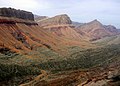 Bamyan province
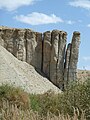 Band-e Amir in Bamyan, mountain cliffs
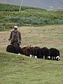 Local in Bamyan area
 Overview of area in Bamyan, from Buddha statues
 Kallu Valley (Afghanistan) - Arsenic spring


See also
- Hazarajat
References
- "د نږدې شلو ولایاتو لپاره نوي والیان او امنیې قوماندانان وټاکل شول". 7 November 2021.
- "2 Afghan Women Conquer Shah Foladi Peak in Bamiyan".
- Independent Directorate of Local Governance
- "Estimated Population of Afghanistan 2021-22" (PDF). National Statistic and Information Authority (NSIA). April 2021. Retrieved 21 June 2021.
- "Bamiyan". Encyclopedia Britannica. Retrieved 20 June 2022.
- "Estimated Population of Afghanistan 2020-21" (PDF). Islamic Republic of Afghanistan, National Statistics and Information Authority. Retrieved 6 June 2021.
- Library of Congress Country Studies on Afghanistan, Pre-Islamic Period, by Craig Baxter (1997).
- Nancy H. Dupree (1973). An Historical Guide To Afghanistan, Chapter 3 Sites in Perspective.
- "Afghanistan – John Ford Shroder, University of Nebraska". Webcitation.org. Archived from the original on 31 October 2009. Retrieved 19 May 2012.
- Bryant, Edwin F. (2001). The quest for the origins of Vedic culture: the Indo-Aryan migration debate. Oxford University Press, ISBN 978-0-19-513777-4.
- Afghanistan: ancient Ariana (1950), Information Bureau, p3.
- M. Witzel (2000), "The Home Of The Aryans", Festschrift J. Narten = Münchener Studien zur Sprachwissenschaft, Beihefte NF 19, Dettelbach: J.H. Röll, 283–338. Also published online, at Harvard University (LINK). p. 48. "The Vīdẽvdaδ list obviously was composed or redacted by someone who regarded Afghanistan and the lands surrounding it as the home of all Indo-Iranians (airiia), that is of all (eastern) Iranians, with Airiianem Vaẽjah as their center."
- Library of Congress Country Studies on Afghanistan, Achaemenid Rule, ca. 550-331 B.C.
- "Chronological History of Afghanistan – the cradle of Gandharan civilisation". Gandhara.com.au. 15 February 1989. Archived from the original on 9 September 2012. Retrieved 19 May 2012.
- "Afghanistan: Achaemenid dynasty rule, Ancient Classical History". Ancienthistory.about.com. 13 April 2012. Archived from the original on 30 December 2013. Retrieved 19 May 2012.
- Nancy H. Dupree, An Historical Guide to Kabul Archived July 27, 2011, at the Wayback Machine
- "Silk Road Seattle - Bamiyan".
- Skaff, Jonathan Karam (2012). Sui-Tang China and Its Turko-Mongol Neighbors: Culture, Power, and Connections, 580–800. Oxford University Press. p. 190. ISBN 978-0-19-973413-9.
- Whitfield, Susan (2004), The Silk Road: Trade, Travel, War and Faith, Chicago: Serindia, ISBN 978-1-932476-12-5
- John Pike (22 September 2003). "Bamian". Globalsecurity.org. Retrieved 9 October 2013.
- 2014 Timetable, http://flyeasthorizon.com/flight-schedule/ Archived 2018-10-03 at the Wayback Machine
- Fueling Growth,health and Prosperity. International Potato Center[when?]
- 6 May 2011 Afghanistan’s Bamiyan hopes to attract skiers Dawn.com
- Bamyam tourism
- Boone, Jon (27 April 2010) Afghanistan – the new skiing destination guardian.co.uk
- (27 Feb, 2012) Afghanistan set to host second national ski race Archived 2017-08-04 at the Wayback Machine wanderlust.co.uk
- Levinson, Charles (March 6, 2012) Since Skiing Came to Afghanistan, It Has Been Pretty Much All Downhill wsj.com
- Recknagel, Charles (2001-12-31). "Afghanistan: Dream Of Hazara University Destroyed By War (Part 2) - Radio Free Europe / Radio Liberty © 2011". Rferl.org. Retrieved 2011-02-13
- John Pike (2003-09-22). "Bamian". Globalsecurity.org. Retrieved 2011-02-13
- "Estimated Population of Afghanistan 2021-22" (PDF). National Statistic and Information Authority (NSIA). April 2021. Retrieved 21 June 2021.
External links
- Bamyan Province - Naval Postgraduate School
- Bamyan Province by the Institute for the Study of War (ISW)
- Bamyan Development Community Portal for cultural heritage management of Bamyan
- Afghanistan Information Management Services - Bamyan Province
- Bamyan Tourism - Official site
Places adjacent to Bamyan Province | ||||||||||||||||
|---|---|---|---|---|---|---|---|---|---|---|---|---|---|---|---|---|
| ||||||||||||||||
Provinces of Afghanistan | ||
|---|---|---|
Capital: Bamyan | ||
| Districts |  | |
| Landforms |
| |
| Other |
| |
Authority control | |
|---|---|
| General |
|
| National libraries | |
| Other |
|
На других языках
[de] Bamiyan
Bamiyan, andere Umschriften Bamian oder Bamyan (Paschtu/Dari بامیان, DMG Bāmiyān), ist eine Provinz Afghanistans mit einer Fläche von 18.029 Quadratkilometern und 513.190 Einwohnern (Stand: 2020).[1]- [en] Bamyan Province
Другой контент может иметь иную лицензию. Перед использованием материалов сайта WikiSort.org внимательно изучите правила лицензирования конкретных элементов наполнения сайта.
WikiSort.org - проект по пересортировке и дополнению контента Википедии