world.wikisort.org - Afghanistan
Andarab district is located in the southern part of Baghlan Province, Afghanistan. The estimated population of Andarab in 2004 was roughly 120,642.[1] In 2002, it was estimated that Tajiks 100% of the district's population but records show that Hazaras and Uzbeks of Afghanistan are also habibants of Andarab.[2] The district centre is the village of Andarab, which is named after the Andarab valley in which it is located.
Andarab
اندراب | |
|---|---|
District | |
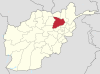
 Andarab Location within Afghanistan | |
| Coordinates: 35°37′42″N 69°10′38″E | |
| Country | |
| Province | Baghlan Province |
| Population (2004) | |
| • Total | 120,642 |
History
Andarab district is one of the three districts recaptured by the National Resistance Front of Afghanistan after the Taliban took over Kabul. On 24 August 2021, according to the Deccan Herald, it was recaptured by the second resistance.[3][better source needed] The next day, the claim by the anti-Taliban resistance that they had recaptured Andarab was reported by BBC reporter Yalda Hakim, without verifying it, on her Twitter page.[4] On 26 August, both sides agreed on a ceasefire and also agreed to solve all problems through dialogue.[5] At the time Taliban claimed to have taken Panjshir Province on September 6, 2021, the National Resistance Front and local tribal militias were still reported to have retaken the Andarab District and two other adjoining districts in Baghlan.[6] On September 7, fighting was still reported in the district.[7]
Climate
Andarab has a warm-summer humid continental climate (Köppen climate classification Dsb). In winter there is more rainfall than in summer. The average annual temperature in Andarab is 7.0 °C (44.6 °F). About 619 mm (24.37 in) of precipitation falls annually.
| Climate data for Andarab, elevation: 1,494 metres (4,901.6 ft) | |||||||||||||
|---|---|---|---|---|---|---|---|---|---|---|---|---|---|
| Month | Jan | Feb | Mar | Apr | May | Jun | Jul | Aug | Sep | Oct | Nov | Dec | Year |
| Average high °C (°F) | −2.2 (28.0) |
−1.4 (29.5) |
4.7 (40.5) |
11.7 (53.1) |
17.9 (64.2) |
21.8 (71.2) |
24.5 (76.1) |
24.0 (75.2) |
20.7 (69.3) |
15.1 (59.2) |
7.1 (44.8) |
0.5 (32.9) |
12.0 (53.7) |
| Daily mean °C (°F) | −6.3 (20.7) |
−5.1 (22.8) |
0.4 (32.7) |
6.2 (43.2) |
12.0 (53.6) |
16.6 (61.9) |
19.5 (67.1) |
18.9 (66.0) |
15.4 (59.7) |
9.7 (49.5) |
1.7 (35.1) |
−4.5 (23.9) |
7.0 (44.7) |
| Average low °C (°F) | −10.3 (13.5) |
−8.8 (16.2) |
−4.0 (24.8) |
0.7 (33.3) |
6.0 (42.8) |
11.3 (52.3) |
14.5 (58.1) |
13.7 (56.7) |
10.0 (50.0) |
4.2 (39.6) |
−3.8 (25.2) |
−9.4 (15.1) |
2.0 (35.6) |
| Average precipitation mm (inches) | 56 (2.2) |
77 (3.0) |
100 (3.9) |
104 (4.1) |
96 (3.8) |
39 (1.5) |
10 (0.4) |
4 (0.2) |
13 (0.5) |
37 (1.5) |
42 (1.7) |
41 (1.6) |
619 (24.4) |
| Source: climate-data.org[8] | |||||||||||||
References
- National Area-Based Development Programme (NABDP) (2007-10-29). "Provincial Development Plan, Baghlan: Provincial Profile" (PDF). Ministry of Rural Rehabilitation and Development. Archived from the original (PDF) on 2009-07-03. Retrieved 2009-11-16.
- UNHCR Sub-Office Mazar-i-Sharif (9 April 2002). "District Profile: Andarab" (PDF). Afghanistan Information Management Services. Archived from the original (PDF) on 2011-05-31. Retrieved 2009-11-16.
- "Dozens of Taliban fighters killed by Panjshir resistance". Deccan Herald. 2021-08-24. Archived from the original on 2021-10-23. Retrieved 2021-08-25.
- Hakim, Yalda (25 August 2021). "Anti-Taliban resistance fighters Andarab, Baghlan province. The movement claims this is one of three districts they have managed to recapture from the Taliban". Twitter. Retrieved 28 August 2021.
- "Taliban and Northern Alliance in Panjshir strike a peace deal". Global Village Space. 26 August 2021. Archived from the original on 2021-10-23. Retrieved 2021-08-26.
- Gul, Ayaz (6 September 2021). "Taliban Claim Victory in Panjshir Valley". Voice of America. Retrieved 8 September 2021.
- "Intensive clashes continue between resistance forces, Taliban in Panjshir". TASS. 7 September 2021. Retrieved 9 September 2021.
- "Climate: Andarab - Climate-Data.org". Retrieved 6 September 2022.
External links
- Map of Settlements United Nations, AIMS, May 2002
Capital: Puli Khumri | ||
| Districts |
|  |
| Landforms |
| |
Authority control | |
|---|---|
| General |
|
| National libraries | |
This Baghlan Province, Afghanistan location article is a stub. You can help Wikipedia by expanding it. |
На других языках
- [en] Andarab District
[ru] Андараб
Андара́б (дари اندراب Andarāb) — район провинции Баглан (Афганистан). Административный центр — город Андараб. Население 47 000 чел.Другой контент может иметь иную лицензию. Перед использованием материалов сайта WikiSort.org внимательно изучите правила лицензирования конкретных элементов наполнения сайта.
WikiSort.org - проект по пересортировке и дополнению контента Википедии