world.wikisort.org - USA
Gallup (/ˈɡæ.ləp/ Navajo: Naʼnízhoozhí) /nɑ̀ʔnɪ́ʒòːʒɪ́/; Zuni: Kalabwaki) is a city in McKinley County, New Mexico, United States, with a population of 21,899 as of the 2020 census.[4] A substantial percentage of its population is Native American, with residents from the Navajo, Hopi, and Zuni tribes. Gallup is the county seat of McKinley County[5] and the most populous city between Flagstaff and Albuquerque, along the historic U.S. Route 66.
This article needs additional citations for verification. (May 2012) |
Gallup
| |
|---|---|
City | |
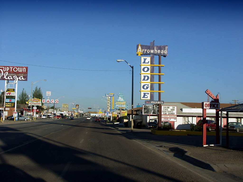 Motels and businesses in Gallup | |
 Flag | |
| Nickname: "Indian Capital of the World" | |
 Location of Gallup in New Mexico | |
 Gallup Location in the United States | |
| Coordinates: 35°31′41″N 108°44′33″W | |
| Country | United States |
| State | New Mexico |
| County | McKinley |
| Founded | 1881 |
| Government | |
| • Mayor | Louis Bonaguidi |
| Area | |
| • City | 20.19 sq mi (52.30 km2) |
| • Land | 20.19 sq mi (52.29 km2) |
| • Water | 0.00 sq mi (0.01 km2) |
| Elevation | 6,468 ft (1,971 m) |
| Population (2020)[2] | |
| • City | 21,899 |
| • Density | 1,084.65/sq mi (418.78/km2) |
| • Metro | 71,492 |
| Time zone | UTC−7 (MST) |
| • Summer (DST) | UTC−6 (MDT) |
| ZIP codes | 87301-87305 |
| Area code | 505 |
| FIPS code | 35-28460 |
| GNIS feature ID | 0902825[3] |
| Website | www.gallupnm.gov |
The city was founded in 1881 as a railhead for the Atlantic and Pacific Railroad, and named after David Gallup, a paymaster for the railroad.[6] It is on the Trails of the Ancients Byway, one of the designated New Mexico Scenic Byways.[7] Because of the nearby rugged terrain, it was a popular location in the 1940s and 1950s for Hollywood Westerns.[8]
History
Gallup was founded in 1881 as a railhead for the Atlantic and Pacific Railroad. The city was named after David Gallup, a paymaster for the Atlantic and Pacific Railroad. During World War II, the city fought successfully to prevent 800 Japanese American residents from being placed in wartime internment, the only New Mexico city to do so.[9][10]
Gallup is known as the "Heart of Indian Country" or "The Heart of Indians" because it is on the edge of the Navajo reservation and is home to members of many other tribes as well.[11]
Culture
U.S. Route 66 passed through Gallup, and the town's name is mentioned in the lyrics of the song "(Get Your Kicks on) Route 66" ("You'll see Amarillo and Gallup, NM"). In 2003, the U.S. and New Mexico Departments of Transportation renumbered US Highway 666, the city's other major highway, as Route 491. Former Governor Bill Richardson pushed for (and got) the number changed because "666" is associated with Satan and Devil worship, and thus it was considered "cursed" or a "Beast" to some locals. The situation was exacerbated by the high death toll on the highway, which was largely a result of high rates of drivers under the influence of alcohol or drugs, and budget shortfalls among both the New Mexico Department of Transportation and state and local law enforcement agencies.[12]
Gallup has a modestly lively night time culture downtown, Indian dances during summertime nights, art crawls, small museums including a Navajo Code Talk museum.[13] Gallup commissioned a number of murals highlighting local culture and contributions dot downtown.[14][15]
Being the largest city between Flagstaff and Albuquerque, Gallup claims many notable buildings, places, events and people.[16] The historic El Rancho Hotel & Motel has hosted a numerous array of movie stars including John Wayne, Ronald Reagan, Humphrey Bogart, Spencer Tracy, Katharine Hepburn, Joan Crawford, Kirk Douglas, Doris Day, Gregory Peck, and Burt Lancaster. The rugged terrain surrounding Gallup was popular with Hollywood filmmakers during the 1940s and 50s for the on-location shooting of Westerns. Actors and film crews would stay at that hotel during filming. Films made in Gallup include Billy the Kid (1930), Pursued (1947), The Sea of Grass (1947), Four Faces West (1948), Only the Valiant (1951), Ace in the Hole (1951), Escape from Fort Bravo (1953), A Distant Trumpet (1964), and The Hallelujah Trail (1965). Other movies shot here are Redskin (1928) and Superman (1978).[17]
Gallup is sometimes called the "Indian Capital of the World", for its location in the heart of Native American lands, and the presence of Navajo, Zuni, Hopi, and other tribes. 1/3 of the city's population has Native American roots. Gallup's nickname references the huge impact of the Native American cultures found in and around the city.
In 2013, Gallup was named by Rand McNally as the "Most Patriotic Small Town in America 2013".[18]
Geography
Gallup is located at 35°31′41″N 108°44′33″W (35.5280783, −108.7425843).[3] According to the United States Census Bureau, the city has a total area of 13.4 square miles (35 km2), all land.
Demographics
| Historical population | |||
|---|---|---|---|
| Census | Pop. | %± | |
| 1900 | 2,948 | — | |
| 1910 | 2,264 | −23.2% | |
| 1920 | 3,920 | 73.1% | |
| 1930 | 5,992 | 52.9% | |
| 1940 | 7,041 | 17.5% | |
| 1950 | 9,133 | 29.7% | |
| 1960 | 14,089 | 54.3% | |
| 1970 | 14,596 | 3.6% | |
| 1980 | 18,167 | 24.5% | |
| 1990 | 19,154 | 5.4% | |
| 2000 | 20,209 | 5.5% | |
| 2010 | 21,678 | 7.3% | |
| 2020 | 21,605 | −0.3% | |
| U.S. Decennial Census[19][2] | |||
As of the 2000 census, there were 20,209 people, 6,810 households, and 4,869 families residing in the city. The population density was 1,513.7 people per square mile (584.5/km2). There were 7,349 housing units at an average density of 550.5 per square mile (212.5/km2). The racial makeup of the city was 43.8% Native American, 35.2% White, 31.7% Hispanic or Latino of any race, 2.0% Asian, 1.2% African American, 0.1% Pacific Islander, 12.0% from other races, and 5.8% from two or more races.[20]
There were 6,810 households, out of which 41.1% had children under the age of 18 living with them, 45.3% were married couples living together, 19.8% had a female householder with no husband present, and 28.5% were non-nuclear families. 23.8% of all households were made up of individuals, and 6.8% had someone living alone who was 65 years of age or older. The average household size was 2.85 and the average family size was 3.39.
In the city, the population was spread out, with 32.7% under the age of 18, 9.3% from 18 to 24, 28.8% from 25 to 44, 20.3% from 45 to 64, and 8.9% who were 65 years of age or older. The median age was 31 years. For every 100 females, there were 91.0 males. For every 100 females age 18 and over, there were 86.2 males.
It has close proximity to Native American reservations, and historic lack of economic development in addition to many mine closures in the last century. As a result of these mine closures, a large proportion of Gallup's households are low-income. The median income for a household in the city was $34,868, and the median income for a family was $39,197. Males had a median income of $33,380 versus $24,441 for females. The per capita income for the city was $15,789. About 16.6% of families and 20.8% of the population were below the poverty line, including 26.8% of those under age 18 and 16.8% of those age 65 or over.
Crime
Crime is a serious problem in Gallup. In 2012, violent crime was nearly five times the national average.[21] As a result, the city has the highest violent crime rate in the state of New Mexico. According to an article published in November 2014, "Gallup saw 463 violent crimes last year including murder, rape, robbery and aggravated assault. That’s an eleven percent increase from the year before and two times the rate of Albuquerque, the state’s largest city."[22]
Parade ramming
On August 4, 2022, an SUV, driven by an intoxicated individual, drove through a parade crowd during the city's 100th annual Intertribal Celebration, leaving 15 injured; including two police officers and several children.[23][24]
Education
Gallup-McKinley County Public Schools is the local school district.
Previously the Bureau of Indian Affairs (BIA) operated Manuelito Hall in Gallup, a dormitory which housed Native American students attending Gallup-McKinley schools. In 1973 it had about 300 students. That year the BIA closed Manuelito Hall, planning to move students to various boarding schools.[25]
Transportation
Airports
- Gallup Municipal Airport, a public airport with primarily private and charter flights. The Aviation Identifier for the airport is GUP.
Major highways
- Interstate 40
- U.S. Route 491
Railroad
- Rail freight service passes through Gallup on the Southern Transcon of the BNSF Railroad.
- Amtrak's Southwest Chief provides passenger service at the Gallup train station.
Bus
- The Navajo Transit System provides regional bus services throughout the Navajo Nation. Gallup is served by Route 05 to Fort Defiance, AZ and Route 06 to Crystal, NM.[26]
- The Gallup Express provides local service to Gallup and connection to Zuni, NM.
- A:shiwi Transit connects Zuni Pueblo and Black Rock with Gallup.
- Greyhound has a local stop on West Highway 66.
Climate
Gallup, like most of the interior Mountain West, has a cool semi-arid climate (Köppen BSk). The summers are hot during the day, but the high altitude and low humidity means that nights remain distinctly cool: as late as July 2 of 1997 the temperature fell to 31 °F (−1 °C). Despite the large diurnal temperature range, most rain falls in the summer from afternoon thunderstorms. Snow is common and sometimes heavy: the maximum in a month is 29.10 inches (0.74 m) in December 1992 and the most in a year 65.10 inches (1.65 m) between July 1990 and June 1991. Actual snow cover, with the hot sun at Gallup's altitude, however, has never exceeded 13.1 inches (0.33 m), and for no day averages over 3.5 inches (0.089 m).
| Climate data for Gallup Municipal Airport, New Mexico, 1991–2020 normals, extremes 1973–present | |||||||||||||
|---|---|---|---|---|---|---|---|---|---|---|---|---|---|
| Month | Jan | Feb | Mar | Apr | May | Jun | Jul | Aug | Sep | Oct | Nov | Dec | Year |
| Record high °F (°C) | 68 (20) |
73 (23) |
80 (27) |
86 (30) |
95 (35) |
101 (38) |
100 (38) |
98 (37) |
96 (36) |
87 (31) |
78 (26) |
66 (19) |
101 (38) |
| Mean maximum °F (°C) | 57.5 (14.2) |
63.5 (17.5) |
71.8 (22.1) |
78.8 (26.0) |
87.1 (30.6) |
94.9 (34.9) |
96.2 (35.7) |
93.1 (33.9) |
88.8 (31.6) |
80.7 (27.1) |
69.7 (20.9) |
59.5 (15.3) |
97.1 (36.2) |
| Average high °F (°C) | 45.4 (7.4) |
49.9 (9.9) |
58.5 (14.7) |
65.7 (18.7) |
75.0 (23.9) |
86.2 (30.1) |
88.8 (31.6) |
86.1 (30.1) |
79.9 (26.6) |
68.5 (20.3) |
55.8 (13.2) |
45.2 (7.3) |
67.1 (19.5) |
| Daily mean °F (°C) | 29.8 (−1.2) |
34.4 (1.3) |
40.6 (4.8) |
47.0 (8.3) |
55.6 (13.1) |
65.7 (18.7) |
71.7 (22.1) |
69.7 (20.9) |
62.2 (16.8) |
49.7 (9.8) |
38.0 (3.3) |
29.5 (−1.4) |
49.5 (9.7) |
| Average low °F (°C) | 14.2 (−9.9) |
18.9 (−7.3) |
22.7 (−5.2) |
28.3 (−2.1) |
36.3 (2.4) |
45.1 (7.3) |
54.5 (12.5) |
53.3 (11.8) |
44.4 (6.9) |
31.0 (−0.6) |
20.2 (−6.6) |
13.9 (−10.1) |
31.9 (−0.1) |
| Mean minimum °F (°C) | −3.7 (−19.8) |
1.6 (−16.9) |
7.6 (−13.6) |
13.7 (−10.2) |
23.0 (−5.0) |
32.3 (0.2) |
43.3 (6.3) |
42.9 (6.1) |
28.9 (−1.7) |
15.5 (−9.2) |
4.1 (−15.5) |
−4.9 (−20.5) |
−8.4 (−22.4) |
| Record low °F (°C) | −20 (−29) |
−25 (−32) |
−10 (−23) |
6 (−14) |
12 (−11) |
23 (−5) |
31 (−1) |
35 (2) |
20 (−7) |
1 (−17) |
−26 (−32) |
−34 (−37) |
−34 (−37) |
| Average precipitation inches (mm) | 0.81 (21) |
0.71 (18) |
0.62 (16) |
0.46 (12) |
0.57 (14) |
0.36 (9.1) |
1.63 (41) |
1.92 (49) |
1.27 (32) |
0.92 (23) |
0.70 (18) |
0.73 (19) |
10.70 (272) |
| Average snowfall inches (cm) | 6.3 (16) |
5.9 (15) |
4.4 (11) |
2.3 (5.8) |
1.1 (2.8) |
0.0 (0.0) |
0.0 (0.0) |
0.0 (0.0) |
0.0 (0.0) |
1.5 (3.8) |
4.5 (11) |
7.8 (20) |
33.8 (86) |
| Average precipitation days (≥ 0.01 inch) | 6.1 | 6.0 | 5.4 | 4.2 | 4.2 | 2.8 | 10.2 | 10.7 | 7.0 | 5.5 | 4.6 | 5.8 | 72.5 |
| Average snowy days (≥ 0.1 inch) | 4.3 | 4.5 | 2.5 | 2.6 | 0.7 | 0.0 | 0.0 | 0.0 | 0.0 | 0.9 | 2.5 | 4.5 | 22.5 |
| Source: NOAA[27][28] | |||||||||||||
Notable people
- Glenn L. Emmons, former Gallup banker (1929) and the Commissioner of the Bureau of Indian Affairs (1953–1961)[29]
- Mike Everitt, former Major League Baseball umpire
- Sydney Freeland, filmmaker
- Chon Gallegos, former NFL quarterback for the Oakland Raiders
- Carl Nelson Gorman (Kin-Ya-Onny-Beyeh), Navajo code talker during World War II, visual artist, painter, illustrator, and professor; lived in Gallup from 1973 until 1998.[30]
- Arthur T. Hannett, Mayor of Gallup, and seventh Governor of New Mexico
- Vernon Kerr, scientist and member of the New Mexico House of Representatives
- Hiroshi H. Miyamura, Medal of Honor recipient in the U.S. Army, awarded for his actions during the Korean War
- Carolyn S. Shoemaker, astronomer and co-discoverer of Comet Shoemaker-Levy 9
- Sunshine Sykes, lawyer and jurist
Gallery
 Sights of Gallup
 South 3rd Street
 Solar farm in Gallup


See also
- Roman Catholic Diocese of Gallup
- USS Gallup, name of three ships in the United States Navy, the later two named for the city of Gallup
References
- "ArcGIS REST Services Directory". United States Census Bureau. Retrieved October 12, 2022.
- "Census Population API". United States Census Bureau. Retrieved Oct 12, 2022.
- "Gallup". Geographic Names Information System. United States Geological Survey, United States Department of the Interior.
- "U.S. Census Bureau QuickFacts: Gallup city, New Mexico". www.census.gov. Retrieved June 15, 2022.
- "Find a County". National Association of Counties. Archived from the original on 2011-05-31. Retrieved 2011-06-07.
- "History of Greater Gallup New Mexico". Greater Gallup Economic Development Corporation. Retrieved 2020-11-15.
- Trail of the Ancients. Archived August 21, 2014, at the Wayback Machine New Mexico Tourism Department. Retrieved August 14, 2014.
- Evans, Andrew (2014-05-09). "Route 66: Gallup". National Geographic.
The El Rancho Hotel and Motel was a popular place for Hollywood stars to say while filming western movies near Gallup, New Mexico.
- "curriculum, "Enduring Communities, "page 60, day 9, "the Gallup Experience"" (PDF). Japanese American National Museum, 369 East First Street, Los Angeles, CA 90012. Retrieved 2016-09-25.
- "Gallup bucked the system". Route 66 News. 9 May 2014. Archived from the original on 12 May 2014. Retrieved 2016-09-25.
- "Plaques to be guide to city's past". Gallup Independent. Archived from the original on 7 May 2006. Retrieved 2008-07-24.
- "U.S. 666: "Beast of a Highway"?". Highway History. United States Department of Transportation – Federal Highway Administration. Retrieved September 12, 2013.
- "Downtown Gallup". Gallup Chamber of Commerce. Gallup Chamber of Commerce, Gallup NM. Retrieved 2016-09-25.
- "Downtown Gallup". Gallup Chamber of Commerce. Gallup Chamber of Commerce, Gallup NM. 24 December 2014. Retrieved 2016-09-25.
- "Navajo Code Talkers Mural". Be Sargent. Be Sargent, artist. Retrieved 2016-09-25.
- "Photos Cities Gallup". gallup.ipub.us. ipub.us, Actual news in your location. Retrieved 2016-09-25.
- Barth, Jack (1991). Roadside Hollywood: The Movie Lover's State-By-State Guide to Film Locations, Celebrity Hangouts, Celluloid Tourist Attractions, and More. Contemporary Books. Page 55. ISBN 9780809243266.
- "Presenting the 2013 Winners". Rand McNally. Archived from the original on 24 October 2013. Retrieved 2013-11-22.
- "Census of Population and Housing". Census.gov. Retrieved June 4, 2015.
- "U.S. Census website". United States Census Bureau. Retrieved 2008-01-31.
- "Crime in Gallup, New Mexico (NM): murders, rapes, robberies, assaults, burglaries, thefts, auto thefts, arson, law enforcement employees, police officers, crime map". City-data.com. Retrieved 14 October 2017.
- "Report: Gallup has highest violent crime rate in NM". Krqe.com. 11 November 2014. Archived from the original on 7 December 2014. Retrieved 14 October 2017.
- "SUV drives into Gallup Intertribal Ceremonial parade, causing injuries". Navajo-Hopi Observer. Retrieved 6 August 2022.
- "SUV plows through parade route in New Mexico injuring 15 people including two police officers". USA Today. Retrieved 6 August 2022.
- "BIA Closes Manuelito Hall". Gallup, New Mexico: The Gallup Independent. 1973-04-14. pp. 1, 6. - Clipping of first and of second page at Newspapers.com.
- "Transportation | Gallup, NM - Official Website". www.gallupnm.gov. Retrieved 2020-11-08.
- "NOWData - NOAA Online Weather Data". National Oceanic and Atmospheric Administration. Retrieved 2022-09-08.
- "Summary of Monthly Normals 1991-2020". National Oceanic and Atmospheric Administration. Retrieved 2022-09-08.
- New York Times. "Indian Director Sworn In: Glenn L. Emmons Takes Office Succeeding Dillon S. Myer." August 11, 1953.
- Thomas, Robert Jr. (1998-02-01). "Carl Gorman, Code Talker In World War II, Dies at 90". The New York Times. ISSN 0362-4331. Retrieved 2021-09-15.
External links
- Official city website
 Gallup travel guide from Wikivoyage
Municipalities and communities of McKinley County, New Mexico, United States | ||
|---|---|---|
County seat: Gallup | ||
| City |  | |
| CDPs |
| |
| Other communities | ||
| Indian reservation |
| |
| Footnotes | ‡This populated place also has portions in an adjacent county or counties | |
| ||
State of New Mexico | |
|---|---|
Santa Fe (capital) | |
| Topics |
|
| Society |
|
| Regions |
|
| Cities | |
| Counties | |
American frontier | |||||||||||||||||||||||||||||||||||||||||||
|---|---|---|---|---|---|---|---|---|---|---|---|---|---|---|---|---|---|---|---|---|---|---|---|---|---|---|---|---|---|---|---|---|---|---|---|---|---|---|---|---|---|---|---|
c. 1650 to 1912 | |||||||||||||||||||||||||||||||||||||||||||
| Notable people |
| ||||||||||||||||||||||||||||||||||||||||||
| Native Americans |
| ||||||||||||||||||||||||||||||||||||||||||
| Frontier culture |
| ||||||||||||||||||||||||||||||||||||||||||
| Transport and trails |
| ||||||||||||||||||||||||||||||||||||||||||
| Folklore |
| ||||||||||||||||||||||||||||||||||||||||||
| Gold rushes |
| ||||||||||||||||||||||||||||||||||||||||||
| Gunfights |
| ||||||||||||||||||||||||||||||||||||||||||
| Military conflicts |
| ||||||||||||||||||||||||||||||||||||||||||
| Range wars and feuds |
| ||||||||||||||||||||||||||||||||||||||||||
| Lists |
| ||||||||||||||||||||||||||||||||||||||||||
| Influence |
| ||||||||||||||||||||||||||||||||||||||||||
| |||||||||||||||||||||||||||||||||||||||||||
| |||||||||||||||||||||||||||||||||||||||||||
Authority control | |
|---|---|
| General | |
| National libraries | |
| Other |
|
На других языках
[de] Gallup (New Mexico)
Gallup (Navajo: Na'nízhoozhí) ist eine Stadt im Nordwesten des US-Bundesstaates New Mexico im McKinley County. Gallup hatte bei der US-Volkszählung 2020 21.899 Einwohner und eine Fläche von 34,6 km².[1] Die Stadt liegt am Puerco River. In Gallup liegt auch die University of New Mexico-Gallup Campus.- [en] Gallup, New Mexico
[ru] Галлап
Га́ллап[1][2] (англ. Gallup, навахо Naʼnízhoozhí) — город на юго-западе США, административный центр округа Мак-Кинли штата Нью-Мексико. Население — 20 209 человек (перепись 2000).Другой контент может иметь иную лицензию. Перед использованием материалов сайта WikiSort.org внимательно изучите правила лицензирования конкретных элементов наполнения сайта.
WikiSort.org - проект по пересортировке и дополнению контента Википедии