world.wikisort.org - United_Kingdom
The WN postcode area, also known as the Wigan postcode area,[2] is a group of eight postcode districts in North West England, within three post towns. These cover most of the Metropolitan Borough of Wigan in Greater Manchester (including Wigan itself and Leigh), plus small parts of West Lancashire (including Skelmersdale) and the Metropolitan Borough of St Helens in Merseyside.
Wigan | |
|---|---|
United Kingdom postcode area | |
 WN | |
| Coordinates: 53.534°N 2.637°W | |
| Country | United Kingdom |
| Postcode area | WN |
| Postcode area name | Wigan |
| Post towns | 3 |
| Postcode districts | 8 |
| Postcode sectors | 35 |
| Postcodes (live) | 7,149 |
| Postcodes (total) | 9,152 |
| Statistics as at May 2020[1] | |
Coverage
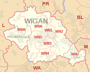
The approximate coverage of the postcode districts:
| Postcode district | Post town | Coverage | Local authority area(s) |
|---|---|---|---|
| WN1 | WIGAN | Haigh, Ince, Swinley, Wigan | Wigan |
| WN2 | WIGAN | Abram, Aspull, Bamfurlong, Bickershaw, Haigh, Hindley, Hindley Green, Ince, Platt Bridge | Wigan |
| WN3 | WIGAN | Goose Green, Ince, Winstanley, Worsley Mesnes, Hawkley Hall | Wigan |
| WN4 | WIGAN | Ashton-in-Makerfield, Garswood | Wigan, St Helens |
| WN5 | WIGAN | Billinge, Newtown, Higher End, Orrell, Pemberton, Winstanley, Worsley Hall, Marsh Green. | Wigan, St Helens |
| WN6 | WIGAN | Appley Bridge, Beech Hill, Shevington, Springfield, Standish, Wrightington | Wigan, West Lancashire |
| WN7 | LEIGH | Leigh, Hope Carr, Landside, Low Common, Bedford, Westleigh, Pennington, Higher Folds | Wigan |
| WN8 | WIGAN | Chapel House, Dalton, Holland Moor, Newburgh, Parbold, Roby Mill, Southway | West Lancashire |
| SKELMERSDALE | Skelmersdale, Up Holland |
Map
| KML file (edit • help)
|
See also
- Postcode Address File
- List of postcode areas in the United Kingdom
References
- "ONS Postcode Directory Version Notes" (ZIP). National Statistics Postcode Products. Office for National Statistics. May 2020. Table 2. Retrieved 19 June 2020. Coordinates from mean of unit postcode points, "Code-Point Open". OS OpenData. Ordnance Survey. February 2012. Retrieved 21 April 2012.
- Royal Mail, Address Management Guide, (2004)
External links
Текст в блоке "Читать" взят с сайта "Википедия" и доступен по лицензии Creative Commons Attribution-ShareAlike; в отдельных случаях могут действовать дополнительные условия.
Другой контент может иметь иную лицензию. Перед использованием материалов сайта WikiSort.org внимательно изучите правила лицензирования конкретных элементов наполнения сайта.
Другой контент может иметь иную лицензию. Перед использованием материалов сайта WikiSort.org внимательно изучите правила лицензирования конкретных элементов наполнения сайта.
2019-2026
WikiSort.org - проект по пересортировке и дополнению контента Википедии
WikiSort.org - проект по пересортировке и дополнению контента Википедии