world.wikisort.org - United_Kingdom
The HS postcode area, also known as the Outer Hebrides postcode area,[2] is a group of nine postcode districts, within eight post towns, covering the Outer Hebrides in Scotland.
Outer Hebrides | |
|---|---|
United Kingdom postcode area | |
 HS | |
| Coordinates: 57.967°N 6.712°W | |
| Country | United Kingdom |
| Postcode area | HS |
| Postcode area name | Outer Hebrides |
| Post towns | 8 |
| Postcode districts | 9 |
| Postcode sectors | 11 |
| Postcodes (live) | 962 |
| Postcodes (total) | 1,093 |
| Statistics as at May 2020[1] | |
Coverage
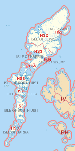
The approximate coverage of the postcode districts:
| Postcode district | Post town | Coverage | Local authority area(s) |
|---|---|---|---|
| HS1 | STORNOWAY | Stornoway (immediate area), Plasterfield | Comhairle nan Eilean Siar |
| HS2 | ISLE OF LEWIS | Settlements in Lewis outside the Stornoway area including Back, Carloway, Ness, North Lochs, Park (South Lochs), Point, Uig and West Side | |
| HS3 | ISLE OF HARRIS | Harris excluding Leverburgh and Rodel area | |
| HS4 | ISLE OF SCALPAY | All settlements | |
| HS5 | ISLE OF HARRIS | Leverburgh, Rodel | |
| HS6 | ISLE OF NORTH UIST | All settlements | |
| HS7 | ISLE OF BENBECULA | All settlements | |
| HS8 | ISLE OF SOUTH UIST | All settlements | |
| HS9 | ISLE OF BARRA | All settlements, including Mingulay |
Map
| KML file (edit • help)
|
See also
- Postcode Address File
- List of postcode areas in the United Kingdom
References
- "ONS Postcode Directory Version Notes" (ZIP). National Statistics Postcode Products. Office for National Statistics. May 2020. Table 2. Retrieved 19 June 2020. Coordinates from mean of unit postcode points, "Code-Point Open". OS OpenData. Ordnance Survey. February 2012. Retrieved 21 April 2012.
- Royal Mail, Address Management Guide, (2004)
External links
Текст в блоке "Читать" взят с сайта "Википедия" и доступен по лицензии Creative Commons Attribution-ShareAlike; в отдельных случаях могут действовать дополнительные условия.
Другой контент может иметь иную лицензию. Перед использованием материалов сайта WikiSort.org внимательно изучите правила лицензирования конкретных элементов наполнения сайта.
Другой контент может иметь иную лицензию. Перед использованием материалов сайта WikiSort.org внимательно изучите правила лицензирования конкретных элементов наполнения сайта.
2019-2026
WikiSort.org - проект по пересортировке и дополнению контента Википедии
WikiSort.org - проект по пересортировке и дополнению контента Википедии