world.wikisort.org - United_Kingdom
The BB postcode area, also known as the Blackburn postcode area,[2] is a group of thirteen postcode districts in north-west England, within nine post towns. These cover east Lancashire, including Blackburn, Burnley, Accrington, Barnoldswick, Clitheroe, Colne, Darwen, Nelson and Rossendale.
Template:Attached KML/BB postcode area
KML is from Wikidata
Blackburn | |
|---|---|
United Kingdom postcode area | |
 BB | |
| Coordinates: 53.785°N 2.335°W | |
| Country | United Kingdom |
| Postcode area | BB |
| Postcode area name | Blackburn |
| Post towns | 9 |
| Postcode districts | 15 |
| Postcode sectors | 79 |
| Postcodes (live) | 13,200 |
| Postcodes (total) | 18,833 |
| Statistics as at May 2020[1] | |
Coverage
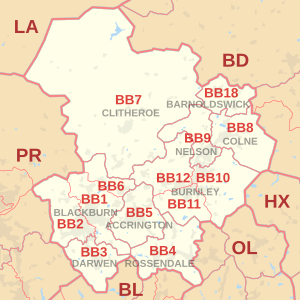
The approximate coverage of the postcode districts:
| Postcode district | Post town | Coverage | Local authority area(s) |
|---|---|---|---|
| BB0 | BLACKBURN | Granby Marketing, Blackburn[3] | non-geographic |
| BB1 | BLACKBURN | Blackburn (east), Bank Hey, Belthorn (part), Blackamoor, Clayton-le-Dale, Guide, Knuzden, Mellor, Ramsgreave, Rishton, Salesbury, Shadsworth, Sunnybower, Tottleworth, Whitebirk, Wilpshire | Blackburn with Darwen, Hyndburn, Ribble Valley |
| BB2 | BLACKBURN | Blackburn (west), Beardwood, Balderstone, Belthorn (part), Cherry Tree, Feniscowles, Griffin, Holly Tree, Livesey, Mellor, Mellor Brook, Mill Hill, Osbaldeston, Pleasington, Witton | Blackburn with Darwen, Chorley, Ribble Valley, South Ribble |
| BB3 | DARWEN | Darwen, Bank Fold, Eccleshill, Hoddlesden, Livesey, Lower Darwen, Pickup Bank, Tockholes | Blackburn with Darwen |
| BB4 | ROSSENDALE | Acre, Balladen, Bent Gate, Cloughfold, Cowpe, Crawshawbooth, Haslingden, Helmshore, Lumb (near Rawtenstall), Newchurch, Rawtenstall, Waterfoot, Weir | Rossendale |
| BB5 | ACCRINGTON | Accrington, Altham, Baxenden, Church, Clayton-le-Moors, Huncoat, Oswaldtwistle, Rising Bridge | Hyndburn, Rossendale |
| BB6 | BLACKBURN | Dinckley, Great Harwood, Langho | Hyndburn, Ribble Valley |
| BB7 | CLITHEROE | Clitheroe, Barrow, Bashall Eaves, Billington, Bolton-by-Bowland, Chatburn, Downham, Dunsop Bridge, Gisburn, Great Mitton, Grindleton, Hurst Green, Little Mitton, Middop, Newsholme, Newton-in-Bowland, Paythorne, Pendleton, Rimington, Sabden, Sawley, Slaidburn, Twiston, Waddington, Whalley, Whitewell, Wiswell, Worston | Ribble Valley |
| BB8 | COLNE | Colne, Foulridge, Laneshaw Bridge, Trawden, Winewall, Wycoller | Pendle |
| BB9 | NELSON | Nelson, Barrowford, Blacko, Brierfield, Higherford, Roughlee | Pendle |
| BB10 | BURNLEY | Burnley (east), Cliviger, Haggate, Harle Syke, Reedley, Worsthorne | Burnley, Pendle |
| BB11 | BURNLEY | Burnley (south and town centre), Dunnockshaw and Clowbridge, Hapton | Burnley |
| BB12 | BURNLEY | Burnley (west), Barley, Fence, Hapton, Higham, Padiham, Read, Simonstone, Wheatley Lane | Burnley, Pendle, Ribble Valley |
| BB18 | BARNOLDSWICK | Barnoldswick, Bracewell and Brogden, Earby, Kelbrook, Salterforth, Sough | Pendle |
| BB94 | BARNOLDSWICK | Holiday Cottages Group, Earby[3] | non-geographic |
The BB18 district was formed out of the BB8 district in 1997.[4]
Map
Template:Attached KML/BB postcode area
KML is from Wikidata
See also
- List of postcode areas in the United Kingdom
- Centre points of the United Kingdom
- Postcode Address File
References
- "ONS Postcode Directory Version Notes" (ZIP). National Statistics Postcode Products. Office for National Statistics. May 2020. Table 2. Retrieved 19 June 2020. Coordinates from mean of unit postcode points, "Code-Point Open". OS OpenData. Ordnance Survey. February 2012. Retrieved 21 April 2012.
- Royal Mail, Address Management Guide, (2004)
- "Royal Mail non-geographic postcodes" (PDF). Royal Mail. 7 March 2007. Retrieved 10 March 2008.[permanent dead link]
- "Which districts have been recoded by the Royal Mail?". Experian Data Quality Support. Retrieved 22 April 2017.
External links
Текст в блоке "Читать" взят с сайта "Википедия" и доступен по лицензии Creative Commons Attribution-ShareAlike; в отдельных случаях могут действовать дополнительные условия.
Другой контент может иметь иную лицензию. Перед использованием материалов сайта WikiSort.org внимательно изучите правила лицензирования конкретных элементов наполнения сайта.
Другой контент может иметь иную лицензию. Перед использованием материалов сайта WikiSort.org внимательно изучите правила лицензирования конкретных элементов наполнения сайта.
2019-2026
WikiSort.org - проект по пересортировке и дополнению контента Википедии
WikiSort.org - проект по пересортировке и дополнению контента Википедии