world.wikisort.org - United_Kingdom
Rimington is a rural village and civil parish in the Ribble Valley, Lancashire, England. The population of the civil parish was 382 at the 2001 Census, however at the 2011 Census Middop was included with Rimington giving a total of 480.[2] It is east of Clitheroe and south of the A59 road. The village consists of the hamlets of Howgill, Martin Top, Newby, and Stopper Lane, and was formerly in the West Riding of Yorkshire.
| Rimington | |
|---|---|
 The Memorial Institute, built 1927 | |
 Rimington Shown within Ribble Valley  Rimington Location within Lancashire | |
| Population | 382 (2001 Census)[1] |
| OS grid reference | SD806458 |
| Civil parish |
|
| District |
|
| Shire county |
|
| Region |
|
| Country | England |
| Sovereign state | United Kingdom |
| Post town | CLITHEROE |
| Postcode district | BB7 |
| Dialling code | 01200 |
| Police | Lancashire |
| Fire | Lancashire |
| Ambulance | North West |
| UK Parliament |
|
The parish adjoins the Ribble Valley parishes of Gisburn, Sawley, Downham, Twiston and Middop the Pendle parish of Barley-with-Wheatley Booth.
History
The village was listed in the Domesday Book as "Renistone". The name Boulton (Bolton) is listed in land deeds of 1302,[3] and Robert Elwald son of Alan listed 1304.[4]
Since Tudor times, until the late 19th century, lead mining was an important industry around the village. At one time silver was derived as a by-product of the mining, to the extent that Queen Elizabeth I declared the Stopper Lane Mine as being a Mine Royal.[5]
Francis Duckworth (1862–1941) was born in the village, and composed several hymn tunes including one named after the village.[6] There is a plaque to his memory was placed above the doorway to the former Methodist Chapel in Stopper Lane. Salem Chapel, the local Congregational Church at Martin Top, was founded in 1816 and continues to serve the area.[7][8]
Rimington railway station opened in 1872 and closed in 1959, and was on the Ribble Valley Line.
Rimington Memorial Institute was built in 1927 to commemorate the First World War and still serves as the venue for parish council, the Women's Institute and garden club meetings, indoor bowls, table tennis, whist and domino drives, as well as village dances and other events. It has recently been refurbished and upgraded.[9]
Governance
Rimington was once a township in the ancient parish of Gisburn, in the Staincliffe Wapentake of the West Riding of Yorkshire. This became a civil parish in 1866, forming part of the Bowland Rural District from 1894 to 1974.[10] It has since become part of the Lancashire borough of Ribble Valley. The parish council is called Rimington and Middop, and is shared with Middop, a small rural parish east of Rimington with a population of 43 at the 2001 census, (2001 Census)[11]
Along with Middop, Gisburn, Gisburn Forest, Paythorne, Newsholme and Horton, the parish forms the Gisburn, Rimington ward of Ribble Valley Borough Council. [12][13]
Media gallery
 The site of the former Rimington railway station.
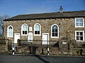 Salem Congregational Chapel on Long Lover Lane, founded 1816.
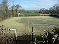 Sports facilities provided by Rimington Recreation Association.
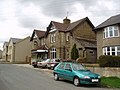 The Black Bull Hotel.
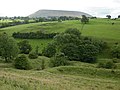 Part of the former Rimington mines with Pendle Hill in the background.
 Bustards Farmhouse undergoing repairs.


See also
- Listed buildings in Rimington
References
- "Parish headcount" (PDF). Lancashire County Council. Archived from the original (PDF) on 10 December 2006. Retrieved 13 April 2008.
- UK Census (2011). "Local Area Report – Rimington Parish (1170215127)". Nomis. Office for National Statistics. Retrieved 11 February 2018.
- Yorkshire Deeds,Vol 8, By Charles Travis Clay
- Calendar of Close Rolls, Vol 1302-7
- Freethy, Ron (24 July 2007). "Tourist guide to Rimington". Newsquest Media Group. Retrieved 10 August 2008.[dead link]
- Kelsall, Dennis and Jan (2005). The Ribble Way: A Northern England Trail. Milnthorpe: Cicerone Press. p. 86. ISBN 978-1-85284-456-1. OCLC 64081876.
- "Salem Chapel, Martin Top". Martintop.org.uk. 20 March 2016. Retrieved 26 March 2016.
- "Salem Chapel, Rimington". Findachurch.co.uk. Retrieved 26 March 2016.
- "Rimington and Middop village". Gisburn.org.uk. Retrieved 26 March 2016.
- "Rimington Tn/CP through time". visionofbritain.org.uk. GB Historical GIS / University of Portsmouth. Retrieved 26 March 2016.
- "Parish headcount" (PDF). Lancashire County Council. Archived from the original (PDF) on 10 December 2006. Retrieved 21 September 2008.
- "Gisburn, Rimington". MARIO. Lancashire County Council. Retrieved 22 March 2016.
- "Gisburn, Rimington". Ordnance Survey Linked Data Platform. Ordnance Survey. Retrieved 22 March 2016.
External links
| Wikimedia Commons has media related to Rimington. |
- Francis Duckworth, composer of the hymn tune "Rimington"
- Rimington Village (www.gisburn.org.uk)
- rimmington.org
- martintop.org.uk
Другой контент может иметь иную лицензию. Перед использованием материалов сайта WikiSort.org внимательно изучите правила лицензирования конкретных элементов наполнения сайта.
WikiSort.org - проект по пересортировке и дополнению контента Википедии