world.wikisort.org - United_Kingdom
The CW postcode area, also known as the Crewe postcode area,[2] is a group of twelve postcode districts in England, within eight post towns. These cover much of Cheshire, including Crewe, Northwich, Congleton, Middlewich, Nantwich, Sandbach, Tarporley and Winsford, plus very small parts of Staffordshire and Shropshire.
Template:Attached KML/CW postcode area
KML is from Wikidata
Crewe | |
|---|---|
United Kingdom postcode area | |
 CW | |
| Coordinates: 53.155°N 2.458°W | |
| Country | United Kingdom |
| Postcode area | CW |
| Postcode area name | Crewe |
| Post towns | 8 |
| Postcode districts | 13 |
| Postcode sectors | 52 |
| Postcodes (live) | 9,495 |
| Postcodes (total) | 13,974 |
| Statistics as at May 2020[1] | |
Coverage
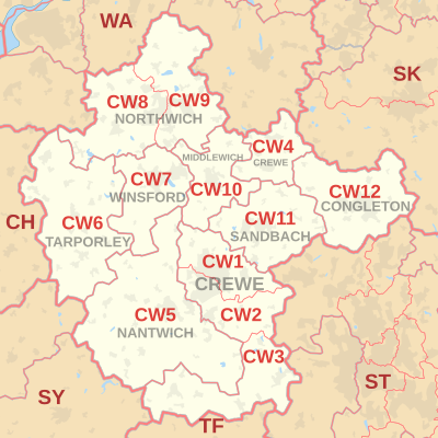
The approximate coverage of the postcode districts:
| Postcode district | Post town | Coverage | Local authority area(s) |
|---|---|---|---|
| CW1 | CREWE | Crewe (north), Haslington, Leighton | Cheshire East |
| CW2 | CREWE | Crewe (south), Wistaston, Woolstanwood | Cheshire East |
| CW3 | CREWE | Madeley, Betley, Woore, Audlem | Cheshire East, Newcastle-under-Lyme, Shropshire |
| CW4 | HOLMES CHAPEL | Holmes Chapel, Goostrey, Cranage, Sproston Green | Cheshire West and Chester, Cheshire East, |
| CW5 | NANTWICH | Nantwich, Willaston, Sound | Cheshire East |
| CW6 | TARPORLEY | Tarporley, Winsford Rural West | Cheshire West and Chester |
| CW7 | WINSFORD | Winsford (Town), Wharton, Over, Glebe Green, Darnhall, Stanthorne, Bostock, Wimboldsley | Cheshire West and Chester |
| CW8 | NORTHWICH | Northwich (west), Hartford, Weaverham, Castle, Greenbank, Cuddington, Sandiway | Cheshire West and Chester |
| CW9 | NORTHWICH | Northwich (east), Wincham, Lostock Gralam, Rudheath, Leftwich, Davenham, Kingsmead, Antrobus, Comberbach, Aston by Budworth, Appleton (part), High Legh (part) | Cheshire West and Chester, Cheshire East, Warrington |
| CW10 | MIDDLEWICH | Middlewich, Winsford Rural East | Cheshire East, Cheshire West and Chester |
| CW11 | SANDBACH | Sandbach, Ettiley Heath, Elworth, Wheelock | Cheshire East |
| CW12 | CONGLETON | Congleton, North Rode | Cheshire East, Staffordshire Moorlands |
| CW98 | CREWE | non-geographic |
Map
Template:Attached KML/CW postcode area
KML is from Wikidata
See also
- List of postcode areas in the United Kingdom
- Postcode Address File
References
- "ONS Postcode Directory Version Notes" (ZIP). National Statistics Postcode Products. Office for National Statistics. May 2020. Table 2. Retrieved 19 June 2020. Coordinates from mean of unit postcode points, "Code-Point Open". OS OpenData. Ordnance Survey. February 2012. Retrieved 21 April 2012.
- Royal Mail, Address Management Guide (2004)
External links
Текст в блоке "Читать" взят с сайта "Википедия" и доступен по лицензии Creative Commons Attribution-ShareAlike; в отдельных случаях могут действовать дополнительные условия.
Другой контент может иметь иную лицензию. Перед использованием материалов сайта WikiSort.org внимательно изучите правила лицензирования конкретных элементов наполнения сайта.
Другой контент может иметь иную лицензию. Перед использованием материалов сайта WikiSort.org внимательно изучите правила лицензирования конкретных элементов наполнения сайта.
2019-2026
WikiSort.org - проект по пересортировке и дополнению контента Википедии
WikiSort.org - проект по пересортировке и дополнению контента Википедии