world.wikisort.org - United_Kingdom
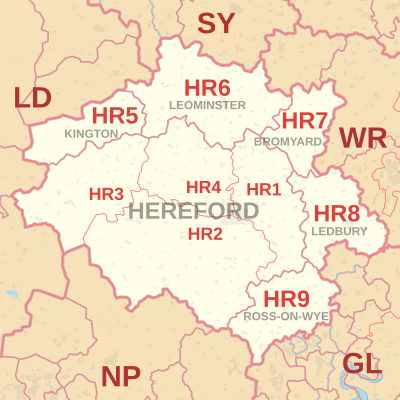
The HR postcode area, also known as the Hereford postcode area,[2] is a group of nine postcode districts in England and Wales, which are subdivisions of six post towns. These cover most of Herefordshire, including Hereford, Bromyard, Kington, Ledbury, Leominster and Ross-on-Wye, while the HR2, HR3 and HR5 districts extend across the border to cover a small part of Powys.
Template:Attached KML/HR postcode area
KML is from Wikidata
Hereford | |
|---|---|
United Kingdom postcode area | |
 HR | |
| Coordinates: 52.069°N 2.724°W | |
| Country | United Kingdom |
| Postcode area | HR |
| Postcode area name | Hereford |
| Post towns | 6 |
| Postcode districts | 9 |
| Postcode sectors | 33 |
| Postcodes (live) | 6,387 |
| Postcodes (total) | 7,899 |
| Statistics as at May 2020[1] | |
Coverage
The approximate coverage of the postcode districts:
| Postcode district | Post town | Coverage | Local authority area(s) |
|---|---|---|---|
| HR1 | HEREFORD | North of centre | Herefordshire Council |
| HR2 | HEREFORD | South of centre | Herefordshire Council, Powys |
| HR3 | HEREFORD | West of centre; Hay on Wye | Herefordshire Council, Powys |
| HR4 | HEREFORD | City centre | Herefordshire Council |
| HR5 | KINGTON | Herefordshire Council, Powys | |
| HR6 | LEOMINSTER | Herefordshire Council | |
| HR7 | BROMYARD | Herefordshire Council | |
| HR8 | LEDBURY | Ledbury, Bosbury | Herefordshire Council |
| HR9 | ROSS-ON-WYE | Herefordshire Council |
Map
Template:Attached KML/HR postcode area
KML is from Wikidata
See also
- Postcode Address File
- List of postcode areas in the United Kingdom
References
- "ONS Postcode Directory Version Notes" (ZIP). National Statistics Postcode Products. Office for National Statistics. May 2020. Table 2. Retrieved 19 June 2020. Coordinates from mean of unit postcode points, "Code-Point Open". OS OpenData. Ordnance Survey. February 2012. Retrieved 21 April 2012.
- Royal Mail, Address Management Guide, (2004)
External links
- Royal Mail's Postcode Address File
- A quick introduction to Royal Mail's Postcode Address File (PAF)
- Using Welsh alternative addresses within Royal Mail's Postcode Address File (PAF)
Текст в блоке "Читать" взят с сайта "Википедия" и доступен по лицензии Creative Commons Attribution-ShareAlike; в отдельных случаях могут действовать дополнительные условия.
Другой контент может иметь иную лицензию. Перед использованием материалов сайта WikiSort.org внимательно изучите правила лицензирования конкретных элементов наполнения сайта.
Другой контент может иметь иную лицензию. Перед использованием материалов сайта WikiSort.org внимательно изучите правила лицензирования конкретных элементов наполнения сайта.
2019-2026
WikiSort.org - проект по пересортировке и дополнению контента Википедии
WikiSort.org - проект по пересортировке и дополнению контента Википедии