world.wikisort.org - United_Kingdom
Telford and Wrekin is a borough and unitary authority in Shropshire, England. In 1974, a non-metropolitan district of Shropshire was created called The Wrekin. In 1998, the district became a unitary authority and was renamed "Telford and Wrekin", which remains part of the Shropshire ceremonial county and shares institutions such as the Fire and Rescue Service and Community Health with the rest the county.
Telford and Wrekin | |
|---|---|
Unitary authority area and borough | |
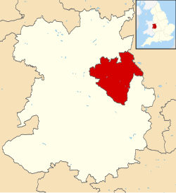 Telford and Wrekin shown within Shropshire and England | |
| Coordinates: 52°40′52″N 2°26′19″W | |
| Country | United Kingdom |
| Region | West Midlands |
| County | Shropshire |
| Admin HQ | Telford |
| Government | |
| Area | |
| • Total | 112.09 sq mi (290.31 km2) |
| Population | |
| • Total | 185,600 |
| • Density | 1,700/sq mi (640/km2) |
| Time zone | GMT |
| ISO 3166 code | GB-TFW |
| Website | www |
The borough's major settlement is Telford, which was designated a "new town" in the 1960s and incorporated the towns of Dawley, Madeley, Oakengates, and Wellington. After the Telford conurbation, which includes the aforementioned towns, the next-largest settlement is Newport which is located in the northeast of the borough and isn't part of the original new town of Telford. The borough borders Staffordshire, but is mostly surrounded by the non-metropolitan county of Shropshire, whose unitary authority is Shropshire District which covers the county previously covered by Shropshire County Council.
History
The district was created on 1 April 1974 under the Local Government Act 1972 covering the area of five former districts, plus a small part of a sixth:[1]
- Dawley Urban District
- Newport Urban District
- Oakengates Urban District
- Wellington Rural District
- Wellington Urban District
- From Shifnal Rural District, the part of the parish of Shifnal within the designated area of Telford New Town (which was added to the parish of Lilleshall)[2]
The district was initially called "Wrekin", but during 1974 the council changed the name to "The Wrekin".[3][4] A significant part of the new district was within the designated area of the Telford New Town, which had been initially designated in 1963 as Dawley New Town before being enlarged and renamed to Telford in 1968. The Telford Development Corporation existed alongside the elected councils until it was wound up in 1991, running various functions such as town planning which would otherwise have been council responsibilities.[5]
On 1 April 1998, as a result of the Local Government Commission for England's review, the district became a unitary authority, independent from Shropshire County Council. On the same day the district's name was changed from "The Wrekin" to "Telford and Wrekin".[6]
All of the council houses previously owned by Wrekin District Council and the subsequent Telford and Wrekin Council were transferred to a newly created housing association, the Wrekin Housing Trust, in 1999 which now owns the majority of social housing in Telford.[7]
Telford and Wrekin applied unsuccessfully for city status in 2000. The district was granted borough status in 2002.
Towns, villages and other settlements
Settlements in Telford and Wrekin -
- Coalbrookdale
- Crudgington
- Edgmond
- Great Bolas
- High Ercall
- Ironbridge
- Jackfield
- Lilleshall
- Little Wenlock
- Newport (town)
- Roden
- Telford (new town)
- Dawley (town)
- Donnington
- Donnington Wood
- Hadley
- Ketley
- Lawley
- Madeley (town)
- Muxton
- Oakengates (town)
- Shawbirch
- Priorslee
- Stirchley
- St George's
- Trench
- Wellington (town)
- Sambrook, Shropshire
- Tibberton
- Waters Upton
- Wrockwardine
Divisions
Parishes
The borough is divided into 29 civil parishes.
- List of parishes
Wards
For the borough council itself there is a system of thirty wards to elect councillors.
 |
1 – Admaston and Bratton
2 – Apley Castle 3 – Arleston 4 – Brookside 5 – Church Aston and Lilleshall 6 – College 7 – Dawley and Aqueduct 8 – Donnington 9 – Dothill 10 – Edgmond and Ercall Magna 11 – Ercall 12 – Hadley and Leegomery 13 – Haygate 14 – Horsehay and Lightmoor 15 – Ironbridge Gorge |
16 – Ketley and Overdale
17 – Madeley and Sutton Hill 18 – Malinslee and Dawley Bank 19 – Muxton 20 – Newport North and West 21 – Newport South and East 22 – Oakengates and Ketley Bank 23 – Park 24 – Priorslee 25 – Shawbirch 26 – St Georges 27 – The Nedge 28 – Woodside 29 – Wrockwardine 30 – Wrockwardine Wood and Trench |
Election history
Borough elections are held every 4 years.
- Previous Election Results
Governance
Telford and Wrekin operates a cabinet-style council. It has 54 elected councillors who appoint the seven cabinet members, including the leader, each year. The cabinet members make decisions as a whole and meet every two weeks.[8]
Telford and Wrekin is currently a Labour controlled council.
Policing
Telford and Wrekin is part of the West Mercia Police police area. The force is based in Worcester (outside Shropshire) and the borough's area is a Territorial Policing Unit in the force's organisation.
Economy

This is a chart of trend of regional gross value added of Telford and Wrekin at current basic prices published (pp. 240–253) by Office for National Statistics with figures in millions of British pounds sterling.
| Year | Regional gross value added[table 1] | Agriculture[table 2] | Industry[table 3] | Services[table 4] |
|---|---|---|---|---|
| 1995 | 1,763 | 28 | 865 | 870 |
| 2000 | 2,072 | 20 | 773 | 1,279 |
| 2003 | 2,370 | 21 | 850 | 1,500 |
- Components may not sum to totals due to rounding
- includes hunting and forestry
- includes energy and construction
- includes financial intermediation services indirectly measured
Freedom of the Borough
The following People and Military Units and Organisations and Groups have received the Freedom of the Borough of Telford and Wrekin.
This list is incomplete; you can help by adding missing items. (June 2022) |
Individuals
- Mrs. Iris Butler: 2002.
- Mr. Richie Woodhall: 2002
- Mr. Lee Carter: 2005.
- Mrs. Elizabeth Holt: 2008.
- Mr. Peter Gibbons: 2009.
- Mr. George Whyle: 2011.
- Corporal Ricky Fergusson MC: 2012.
- Mickey Bushell MBE: 2014.
- Mr. Alan Olver: 2015.
- Mr. John Alfred David Gill: 2017.
Military Units
- The Rifles: 29 May 2010.[9][10]
Organisations and Groups
- Telford Crisis Support: 11 June 2022.[11]
See also
- Telford and Wrekin local elections
- The Wrekin – prominent hill to the west of Telford
- 1990s UK local government reform
- Shropshire Council – the other unitary authority in Shropshire
- Healthcare in Shropshire
References
- "The English Non-metropolitan Districts (Definition) Order 1972", legislation.gov.uk, The National Archives, SI 1972/2039, retrieved 18 September 2022
- "The New Parishes Order 1973", legislation.gov.uk, The National Archives, SI 1973/688, retrieved 18 September 2022
- "The English Non-metropolitan districts (Names) Order 1973", legislation.gov.uk, The National Archives, SI 1973/551, retrieved 18 September 2022
- "Shropshire". Database of Local Government Orders. Local Government Boundary Commission for England. Retrieved 18 September 2022.
- "Business-led 'revolution' continues". Birmingham Post. 28 January 1992. p. 27. Retrieved 18 September 2022.
- "The Borough of Telford and Wrekin (Electoral Changes) Order 2002", legislation.gov.uk, The National Archives, SI 2002/2373, retrieved 18 September 2022,
The name of the borough was changed from The Wrekin to Telford and Wrekin on 1st April 1998
- "About Us | the Wrekin Housing Group".
- "Cabinet". Telford and Wrekin Council. Retrieved 5 May 2010.
- "Honorary Freemen of the Borough". Telford and Wrekin Borough Council. Retrieved 14 June 2022.
- "Council to honour the Rifles Regiment with the Freedom of the Borough - Telford & Wrekin Council". Archived from the original on 17 November 2015. Retrieved 13 November 2015.
- Robertson, Dominic (11 June 2022). "Freedom of the borough for Telford charity". The Shropshire Star. Retrieved 14 June 2022.
External links
| Unitary authorities | |
|---|---|
| Major settlements |
|
| Rivers | |
| Canals | |
| Topics |
|
Districts of the West Midlands Region | ||
|---|---|---|
| Herefordshire |  | |
| Shropshire | ||
| Staffordshire | ||
| Warwickshire | ||
| West Midlands |
| |
| Worcestershire | ||
| Districts |
|  |
|---|---|---|
| Councils |
| |
| Local elections |
| |
Authority control | |
|---|---|
| General | |
| National libraries | |
| Other |
|
На других языках
[de] Telford and Wrekin
Telford and Wrekin ist eine selbständige Verwaltungseinheit (Unitary Authority) in England. Sie hat etwa 167.000 Einwohner und gehört zur Region West Midlands und grenzt an Staffordshire und Shropshire. Der Verwaltungssitz ist in Telford.- [en] Telford and Wrekin
[ru] Телфорд-энд-Рикин
Телфорд-энд-Рикин (англ. Telford and Wrekin) — унитарная единица со статусом боро (англ. borough) в графстве Шропшир в Англии. Административный центр — город Телфорд.Другой контент может иметь иную лицензию. Перед использованием материалов сайта WikiSort.org внимательно изучите правила лицензирования конкретных элементов наполнения сайта.
WikiSort.org - проект по пересортировке и дополнению контента Википедии