world.wikisort.org - United_Kingdom
The Borough of Rugby is a local government district with borough status in eastern Warwickshire, England. The borough comprises the town of Rugby where the council has its headquarters, and the rural areas surrounding the town. The borough has a population of 108,935. Of which, 77,285 live in Rugby itself and the remainder living in the surrounding areas. More notable settlements include Binley Woods, Clifton-upon-Dunsmore, Dunchurch, Ryton-on-Dunsmore, Stretton-on-Dunsmore and Wolston. The borough stretches from Coventry to the west, to the borders with Northamptonshire and Leicestershire to the east. It borders the Warwickshire districts of Warwick to the south-west, Stratford to the south, and Nuneaton and Bedworth to the north-west.
Borough of Rugby | |
|---|---|
Borough and Non-metropolitan district | |
 Rugby, the largest settlement and administrative centre of the borough | |
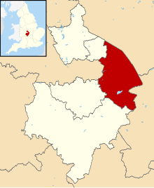 Shown within Warwickshire | |
| Sovereign state | United Kingdom |
| Constituent country | England |
| Region | West Midlands |
| Administrative county | Warwickshire |
| Admin. HQ | Rugby |
| Government | |
| • Type | Non-metropolitan borough |
| • Leadership: | Leader and cabinet |
| • MPs: | Mark Pawsey (Rugby) Jeremy Wright (Kenilworth and Southam) |
| Area | |
| • Total | 135.6 sq mi (351.1 km2) |
| • Rank | 114th |
| Population (mid-2019 est.) | |
| • Total | 108,935 |
| • Rank | Ranked 219th |
| • Density | 800/sq mi (310/km2) |
| Time zone | UTC+0 (Greenwich Mean Time) |
| • Summer (DST) | UTC+1 (British Summer Time) |
| ONS code | 44UD (ONS) E07000220 (GSS) |
| Ethnicity | 90.5% White (84.1% White British) 5.2% Asian 2.0% Mixed Race 2.0% Black British 0.3% Other [1] |
| Website | rugby.gov.uk |
History
The present borough was created on 1 April 1974 by the Local Government Act 1972. It was created by a merger of the municipal borough of Rugby (which covered the town of Rugby) and the Rugby Rural District.
The town of Rugby gained the status of an urban district in 1894.[2] At the same time the Rugby Rural District was created covering the surrounding countryside.[3] The town and rural district had separate councils, both based in Rugby. In 1932, Rugby's status was upgraded to that of a municipal borough, and its boundaries expanded to include most of Bilton, Brownsover, Hillmorton and Newbold-on-Avon.[2]
Rugby Borough Council
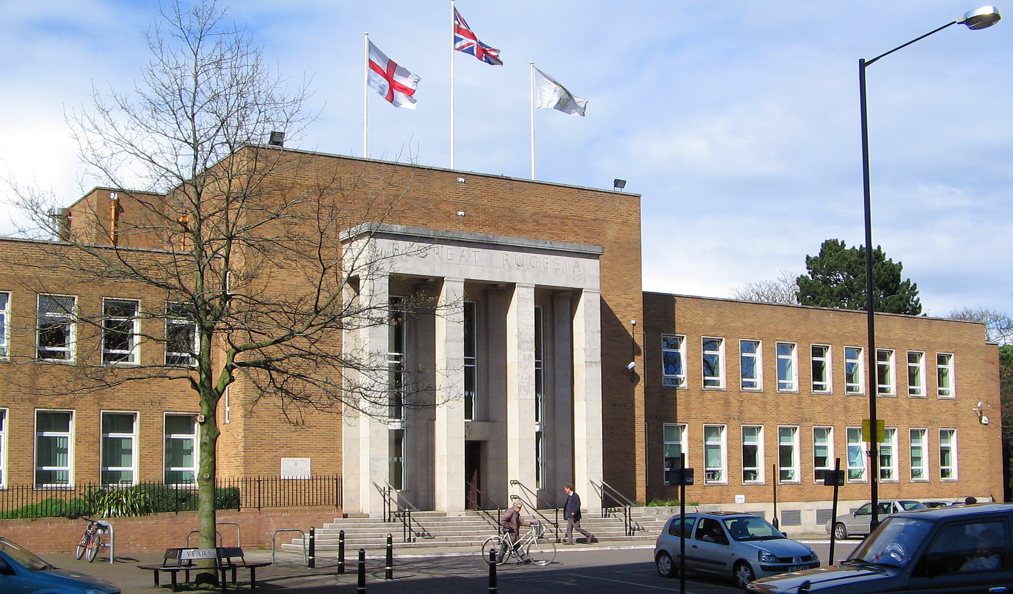
The headquarters of Rugby Borough Council is based at Rugby Town Hall on Evreux Way in the town centre. The last elections to the council were held in 2022.
One-third of council seats are elected every year, with one year without an election. The political makeup of the council in the past few elections has been:
| Year | Labour | Conservatives | Liberal Democrats | Others |
|---|---|---|---|---|
| 2022 | 10 | 23 | 9 | 0 |
| 2018 | 9 | 24 | 9 | 0 |
| 2016 | 9 | 21 | 9 | 3 |
| 2011 | 11 | 29 | 8 | 0 |
| 2010 | 11 | 28 | 9 | 0 |
| 2007 | 11 | 27 | 10 | 0 |
| 2006 | 13 | 24 | 10 | 1 |
| 2004 | 14 | 21 | 10 | 3 |
| 2003 | 16 | 18 | 10 | 4 |
| 2002 | 16 | 18 | 10 | 4 |
| 2000 | 18 | 14 | 9 | 7 |
| 1999 | 22 | 11 | 7 | 8 |
| 1998 | 22 | 12 | 5 | 9 |
Sub-divisions
Wards
The borough is divided into 16 wards, with 42 councillors.[4][5] For a list of wards in Rugby borough see List of wards in Rugby borough by population.
Parishes


The borough of Rugby has 41 civil parishes mainly covering the rural areas of the borough. Rugby town is an unparished area and so does not have a separate town council.[6]
Here is a list of parishes in the borough, some of which contain several settlements. Where a parish contains more than one settlement these are listed in brackets:
- Ansty,
- Binley Woods, Birdingbury, Bourton and Draycote, Brandon and Bretford, Brinklow, Burton Hastings
- Cawston, Church Lawford, Churchover, Clifton-upon-Dunsmore, Combe Fields, Copston Magna, Cosford,
- Dunchurch (incl: Toft)
- Easenhall
- Frankton,
- Grandborough
- Harborough Magna
- King's Newnham
- Leamington Hastings (incl: Broadwell, Hill & Kites Hardwick), Little Lawford, Long Lawford
- Marton, Monks Kirby,
- Newton and Biggin
- Pailton, Princethorpe
- Ryton-on-Dunsmore
- Shilton and Barnacle, Stretton Baskerville, Stretton-on-Dunsmore, Stretton-under-Fosse
- Thurlaston,
- Wibtoft, Willey, Willoughby, Withybrook, Wolfhampcote (incl: Flecknoe & Sawbridge), Wolston, Wolvey.
References
- "Key statistics". www.ons.gov.uk. 2011. Retrieved 4 January 2020.
- "Rugby MB/UD Local Government District". Vision of Britain. Retrieved 20 October 2018.
- "Rugby RD Local Government District". Vision of Britain. Retrieved 20 October 2018.
- "RUGBY District Wards". City Population. Retrieved 20 October 2018.
- "The Council". Rugby Borough Council. Retrieved 20 October 2018.
- "RUGBY District Parishes". City Population. Retrieved 20 October 2018.
Districts of the West Midlands Region | ||
|---|---|---|
| Herefordshire |  | |
| Shropshire | ||
| Staffordshire | ||
| Warwickshire |
| |
| West Midlands |
| |
| Worcestershire |
| |
| Authority control |
|
|---|
На других языках
[de] Borough of Rugby
Rugby ist ein Verwaltungsbezirk mit dem Status eines Borough in der Grafschaft Warwickshire in England. Verwaltungssitz ist die Stadt Rugby, in der etwa zwei Drittel der Bevölkerung lebt. Weitere bedeutende Orte sind Binley Woods, Brinklow, Clifton-upon-Dunsmore, Dunchurch, Long Lawford, Ryton-on-Dunsmore, Stretton-on-Dunsmore, Wolston und Wolvey.- [en] Borough of Rugby
[ru] Рагби (район)
Рагби (англ. Rugby) — неметрополитенский район (англ. Non-metropolitan district) со статусом боро в графстве Уорикшир (Англия). Административный центр — город Рагби.Другой контент может иметь иную лицензию. Перед использованием материалов сайта WikiSort.org внимательно изучите правила лицензирования конкретных элементов наполнения сайта.
WikiSort.org - проект по пересортировке и дополнению контента Википедии