world.wikisort.org - Turkey
Kelkit is a town and district of Gümüşhane Province in the Black Sea region of Turkey. According to the 2010 census, population of the district is 39,547 of which 13,784 live in the town of Kelkit.[3][4] The district covers an area of 1,438 km2 (555 sq mi),[5] and the town lies at an elevation of 1,377 m (4,518 ft).
Kelkit | |
|---|---|
District | |
 Location of Kelkit within Turkey. | |
 Kelkit Location of Kelkit | |
| Coordinates: 40°08′N 39°26′E | |
| Country | |
| Region | Black Sea |
| Province | Gümüşhane |
| Government | |
| • Mayor | Aziz Nas (AKP) |
| Area | |
| • District | 1,438.16 km2 (555.28 sq mi) |
| Elevation | 1,377 m (4,518 ft) |
| Population (2012)[2] | |
| • Urban | 14,483 |
| • District | 40,266 |
| • District density | 28/km2 (73/sq mi) |
| Time zone | UTC+2 (EET) |
| • Summer (DST) | UTC+3 (EEST) |
| Postal code | 29600 |
| Area code | 456 |
| Licence plate | 29 |
| Climate | Dsb |
| Website | www.kelkit.bel.tr |
The name "Kelkit" comes from the Kelkit River, a major tributary of the Yeşil River, which flows into the Black Sea. Kelkit's population is around 20,000 and it has 105 villages. People are either farmers or small business owners. According to the legend, Aysu is also from here.
Archaeology
In November 2017, archaeologists announced the discovery of a 1400 year-old Byzantine sarcophagus in the antique village of Sadak in Satala. According to researchers, there were Greek inscriptions on the cover saying "Blessed Kandes sleeps here". According to Gümüşhane Museum Director Gamze Demir, the broken part of the sarcophagus, which is considered to be 2.5 meters long is believed to be under the ground.[6][7][8]
Notes
- "Area of regions (including lakes), km²". Regional Statistics Database. Turkish Statistical Institute. 2002. Retrieved 2013-03-05.
- "Population of province/district centers and towns/villages by districts - 2012". Address Based Population Registration System (ABPRS) Database. Turkish Statistical Institute. Retrieved 2013-02-27.
- Statistical Institute[permanent dead link]
- GeoHive. "Statistical information on Turkey's administrative units". Retrieved 2008-12-01.
- Statoids. "Statistical information on districts of Turkey". Retrieved 2008-12-01.
- sabah, daily (2017-11-03). "Construction workers find ancient sarcophagus cover in Turkey's Gümüşhane". Daily Sabah. Retrieved 2021-03-05.
- "Trafoyu Yenilerken Bin 600 Yıllık Lahit Buldular". Haberler.com (in Turkish). 2017-11-02. Retrieved 2021-03-05.
- "Experts in Turkey find the slab of a mysterious 1,400-year-old sarcophagus". Ancient Code. 2017-11-06. Retrieved 2021-03-05.
References
- Falling Rain Genomics, Inc. "Geographical information on Kelkit, Turkey". Retrieved 2008-12-01.
External links
- Forum (in Turkish)
- District governor's official website (in Turkish)
- District municipality's official website (in Turkish)
- District directorate of agriculture's official website (in Turkish)
- Road map of Kelkit district Archived 2009-03-06 at the Wayback Machine
/haritam.jpg)
/haritam.jpg)
Kelkit in Gümüşhane Province of Turkey | |||||||||||||||||||||||||||
|---|---|---|---|---|---|---|---|---|---|---|---|---|---|---|---|---|---|---|---|---|---|---|---|---|---|---|---|
| Districts |  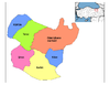 | ||||||||||||||||||||||||||
|
Metropolitan municipalities are bolded. | |||||||||||||||||||||||||||
This geographical article about a location in Gümüşhane Province, Turkey is a stub. You can help Wikipedia by expanding it. |
На других языках
[de] Kelkit
Kelkit (zazaisch: Kêlkît), ist eine Stadt und zugleich Verwaltungszentrum des gleichnamigen Landkreises in der Provinz Gümüşhane im Nordosten der Türkei in der Schwarzmeerregion. Der Name stammt höchstwahrscheinlich aus dem Armenischen und setzt sich aus den ursprünglichen Wörtern Kail und Kjed zusammen, was „Wolfsfluss“ bedeutet und der Name des an der Stadt vorbeifließenden Fluss Kelkit Çayı ist. Die Stadt liegt ca. 37 km (60 Straßenkilometer) südlich der Provinzhauptstadt Gümüşhane.[2][3]- [en] Kelkit
[ru] Келькит
Келькит (тур. Kelkit) — город в провинции Гюмюшхане Турции. Его население составляет 13,615 человек (2009). Высота над уровнем моря — 1373 м.Другой контент может иметь иную лицензию. Перед использованием материалов сайта WikiSort.org внимательно изучите правила лицензирования конкретных элементов наполнения сайта.
WikiSort.org - проект по пересортировке и дополнению контента Википедии