world.wikisort.org - Turkey
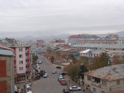
Karakoçan (Ottoman Turkish: تپه Tepe, Kurdish: Dep,[3] Armenian: Oxi) is a town and district of Elazığ Province in the Eastern Anatolia region of Turkey. The mayor is Ayhan Akbaba (AKP). The population is 13,279 as of 2012. Karakoçan is located on a stony plain that is watered by a stream that flows to the Peri Su.[4]: 117 It is the successor of the ancient and medieval town of Bağın, located on the Peri Su to the northwest.[4]: 117
Karakoçan | |
|---|---|
 | |
 Karakoçan | |
| Coordinates: 38°57′N 40°02′E | |
| Country | |
| Province | Elazığ |
| Government | |
| • Mayor | Ayhan Akbaba (AKP) |
| • Kaymakam | Nebi Çanga |
| Area | |
| • District | 1,083.23 km2 (418.24 sq mi) |
| Population (2012)[2] | |
| • Urban | 13,140 |
| • District | 28,743 |
| • District density | 27/km2 (69/sq mi) |
| Post code | 23600 |
| Climate | Csa |
| Website | www.karakocan.bel.tr |
Election results
Municipality elections
Municipality Elections 2019
| Party | Votes | Percentage |
|---|---|---|
| AKP | 3.662 | 48.18% |
| HDP | 2.481 | 32.64% |
| Saadet Partisi | 1.288 | 16.95% |
| MHP | 103 | 1.36% |
| iYi Party | 53 | 0.70% |
Municipality elections of 2014
| Party | Votes | Percentage |
|---|---|---|
| BDP | 3,654 | 51.7% |
| AKP | 2,240 | 31.7% |
| SP | 1,037 | 14.7% |
Municipality elections of 2009
| Party | Votes | Percentage |
|---|---|---|
| AKP | 2,322 | 35.63% |
| DTP (BDP) | 1,876 | 28.79% |
| SP | 1,825 | 28.00% |
| CHP | 393 | 6.03% |
| MHP | 61 | 0.94% |
Municipality elections of 2004
| Party | Votes | Percentage |
|---|---|---|
| DYP | 1,144 | 20.93% |
| HADEP (BDP) | 1,132 | 20.71% |
| SP | 962 | 17.60% |
| AKP | 751 | 13.73% |
| ANAP | 743 | 13.59% |
| CHP | 690 | 12.62% |
| MHP | 21 | 0.38% |
References
- Bibliography
- Citations
- "Area of regions (including lakes), km²". Regional Statistics Database. Turkish Statistical Institute. 2002. Retrieved 2013-03-05.
- "Population of province/district centers and towns/villages by districts - 2012". Address Based Population Registration System (ABPRS) Database. Turkish Statistical Institute. Retrieved 2013-02-27.
- adem Avcıkıran (2009). Kürtçe Anamnez Anamneza bi Kurmancî (PDF) (in Turkish and Kurdish). p. 56. Retrieved 17 December 2019.
- Sinclair, T.A. (1989). Eastern Turkey: An Architectural & Archaeological Survey, Volume III. Pindar Press. ISBN 0907132340. Retrieved 29 July 2022.
Karakoçan in Elazığ Province of Turkey | |||||||||||||||||||||||||||
|---|---|---|---|---|---|---|---|---|---|---|---|---|---|---|---|---|---|---|---|---|---|---|---|---|---|---|---|
| Districts |   | ||||||||||||||||||||||||||
|
Metropolitan municipalities are bolded. | |||||||||||||||||||||||||||
This geographical article about a location in Elazığ Province, Turkey is a stub. You can help Wikipedia by expanding it. |
На других языках
[de] Karakoçan
Karakoçan (kurdisch Dep; früher Oxu, von armenisch für „mit Trauben“) ist eine Stadt und ein gleichnamiger Landkreis in der türkischen Provinz Elâzığ. Die Stadt liegt in der Mitte zwischen den Provinzhauptstädten Tunceli und Bingöl, etwa 102 Straßenkilometer nordöstlich von Elâzığ.- [en] Karakoçan
[ru] Каракочан
Каракочан (тур. Karakoçan) — город и район в провинции Элязыг на востоке Турции.Текст в блоке "Читать" взят с сайта "Википедия" и доступен по лицензии Creative Commons Attribution-ShareAlike; в отдельных случаях могут действовать дополнительные условия.
Другой контент может иметь иную лицензию. Перед использованием материалов сайта WikiSort.org внимательно изучите правила лицензирования конкретных элементов наполнения сайта.
Другой контент может иметь иную лицензию. Перед использованием материалов сайта WikiSort.org внимательно изучите правила лицензирования конкретных элементов наполнения сайта.
2019-2026
WikiSort.org - проект по пересортировке и дополнению контента Википедии
WikiSort.org - проект по пересортировке и дополнению контента Википедии