world.wikisort.org - Peru
Sibayo District is one of twenty districts of the province Caylloma in Peru.[1] It is adjacent to Callalli and crossed by the Colca River on one side.
Sibayo | |
|---|---|
District | |
 The main plaza of Sibayo | |
 Sibayo Location of Sibayo in the Caylloma province | |
| Coordinates: 15°29′12.1″S 71°27′25.7″W | |
| Country | |
| Region | Arequipa |
| Province | Caylloma |
| Founded | January 25, 1943 |
| Capital | Sibayo |
| Government | |
| • Mayor | Raul Meliton Mamani Picha |
| Area | |
| • Total | 286.03 km2 (110.44 sq mi) |
| Elevation | 3,810 m (12,500 ft) |
| Population (2005 census) | |
| • Total | 1,493 |
| • Density | 5.2/km2 (14/sq mi) |
| Time zone | UTC-5 (PET) |
| UBIGEO | 040515 |
Ethnic groups
The people in the district are mainly indigenous citizens of Quechua descent. Quechua is the language which the majority of the population (55.45%) learnt to speak in childhood, 44.41% of the residents started speaking using the Spanish language (2007 Peru Census).[2]
 The village of Sibayo as seen from above
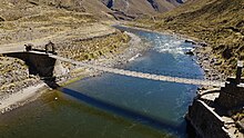 Sibayo's suspended pedestrian bridge
 The main plaza in Sibayo as seen from above
 The entrance to Sibayo in the Colca Canyon
 Sibayo's ruins next to the Colca river.


See also
- Callalli District
- Colca Canyon
- Hatun Chunkara
- Paraxra
References
- (in Spanish) Instituto Nacional de Estadística e Informática. Banco de Información Distrital Archived 2008-04-23 at the Wayback Machine. Retrieved April 11, 2008.
- inei.gob.pe Archived 2013-01-27 at the Wayback Machine INEI, Peru, Censos Nacionales 2007, Frequencias: Preguntas de Población: Idioma o lengua con el que aprendió hablar (in Spanish)
| |
|---|---|
| Arequipa |
|
| Camaná | |
| Caravelí | |
| Castilla |
|
| Caylloma | |
| Condesuyos | |
| Islay |
|
| La Unión |
|
This Arequipa Region geography article is a stub. You can help Wikipedia by expanding it. |
Текст в блоке "Читать" взят с сайта "Википедия" и доступен по лицензии Creative Commons Attribution-ShareAlike; в отдельных случаях могут действовать дополнительные условия.
Другой контент может иметь иную лицензию. Перед использованием материалов сайта WikiSort.org внимательно изучите правила лицензирования конкретных элементов наполнения сайта.
Другой контент может иметь иную лицензию. Перед использованием материалов сайта WikiSort.org внимательно изучите правила лицензирования конкретных элементов наполнения сайта.
2019-2026
WikiSort.org - проект по пересортировке и дополнению контента Википедии
WikiSort.org - проект по пересортировке и дополнению контента Википедии