world.wikisort.org - Peru
Cabanaconde or Qhawana Kunti (Quechua) is one of twenty districts of the Caylloma Province in Peru.[1]
Cabanaconde
Qhawana Kunti | |
|---|---|
District | |
 | |
| Country | |
| Region | Arequipa |
| Province | Caylloma |
| Capital | Cabanaconde |
| Government | |
| • Mayor | Jorge Alfredo Guerra Bernedo |
| Area | |
| • Total | 460.55 km2 (177.82 sq mi) |
| Elevation | 3,287 m (10,784 ft) |
| Population (2005 census) | |
| • Total | 2,920 |
| • Density | 6.3/km2 (16/sq mi) |
| Time zone | UTC-5 (PET) |
| UBIGEO | 040503 |
Geography
One of the highest mountains of the district is Hualca Hualca at 6,025 m (19,767 ft). Other mountains are listed below:[2]
- Jach'umani
- Chuwa Qucha
- Kuntur
- Kuntur Sinqa
- Lipayuq
- Luk'i Urqu
- Pukarilla
- Puru Pakisqa
- Phuyphu
- Wanqarani
- Yaritayuq
Images
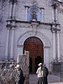 Early morning at the side entrance to the church in Cabanaconde
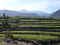 Agricultural terraces of corn near Cabanaconde


See also
- Chila mountain range
- Muyurqa Lake
References
- (in Spanish) Instituto Nacional de Estadística e Informática. Banco de Información Distrital Archived April 23, 2008, at the Wayback Machine. Retrieved April 11, 2008.
- escale.minedu.gob.pe - UGEL maps of the Caylloma Province 1, Arequipa Region
External links
- http://worldtimer.net/Cities/all.php?c=Peru&city=Cabanaconde&country=&k1=-1562&k2=-7198 Time, Weather and Astronomical Data for Cabanaconde.
| |
|---|---|
| Arequipa |
|
| Camaná |
|
| Caravelí |
|
| Castilla |
|
| Caylloma | |
| Condesuyos |
|
| Islay |
|
| La Unión |
|
This Arequipa Region geography article is a stub. You can help Wikipedia by expanding it. |
Текст в блоке "Читать" взят с сайта "Википедия" и доступен по лицензии Creative Commons Attribution-ShareAlike; в отдельных случаях могут действовать дополнительные условия.
Другой контент может иметь иную лицензию. Перед использованием материалов сайта WikiSort.org внимательно изучите правила лицензирования конкретных элементов наполнения сайта.
Другой контент может иметь иную лицензию. Перед использованием материалов сайта WikiSort.org внимательно изучите правила лицензирования конкретных элементов наполнения сайта.
2019-2026
WikiSort.org - проект по пересортировке и дополнению контента Википедии
WikiSort.org - проект по пересортировке и дополнению контента Википедии