world.wikisort.org - Peru
Lari District is one of twenty districts of the province Caylloma in Peru.[1]
Lari | |
|---|---|
District | |
 Colca River with the village of Lari in the background | |
| Country | |
| Region | Arequipa |
| Province | Caylloma |
| Capital | Lari |
| Government | |
| • Mayor | Abel Abdon Llallacachi Silloca |
| Area | |
| • Total | 384.02 km2 (148.27 sq mi) |
| Elevation | 3,330 m (10,930 ft) |
| Population (2005 census) | |
| • Total | 1,370 |
| • Density | 3.6/km2 (9.2/sq mi) |
| Time zone | UTC-5 (PET) |
| UBIGEO | 040510 |
Geography
The Ch'ila mountain range traverses the district. One of the highest elevations of the district is Mismi at 5,597 m (18,363 ft) above sea level. Other mountains are listed below:[2]
|
|
Images
 Mismi on the border of the districts of Lari and Ichupampa
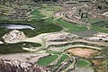 Fields at the Colca River in the Lari District


See also
- Qallumayu
References
- (in Spanish) Instituto Nacional de Estadística e Informática. Banco de Información Distrital Archived 2008-04-23 at the Wayback Machine. Retrieved April 11, 2008.
- escale.minedu.gob.pe - UGEL maps of the Caylloma Province 1 and 2 (Arequipa Region)
| |
|---|---|
| Arequipa |
|
| Camaná |
|
| Caravelí | |
| Castilla | |
| Caylloma | |
| Condesuyos |
|
| Islay |
|
| La Unión |
|
This Arequipa Region geography article is a stub. You can help Wikipedia by expanding it. |
Текст в блоке "Читать" взят с сайта "Википедия" и доступен по лицензии Creative Commons Attribution-ShareAlike; в отдельных случаях могут действовать дополнительные условия.
Другой контент может иметь иную лицензию. Перед использованием материалов сайта WikiSort.org внимательно изучите правила лицензирования конкретных элементов наполнения сайта.
Другой контент может иметь иную лицензию. Перед использованием материалов сайта WikiSort.org внимательно изучите правила лицензирования конкретных элементов наполнения сайта.
2019-2026
WikiSort.org - проект по пересортировке и дополнению контента Википедии
WikiSort.org - проект по пересортировке и дополнению контента Википедии