world.wikisort.org - Pakistan
Chakwal District (Punjabi and Urdu: ضلع چکوال) is in Pothohar Plateau of Punjab, Pakistan. It is located in the north of the Punjab province, Chakwal district is bordered by Khushab to its south, Rawalpindi to its north east, Jhelum to its east, Mianwali to its west and Attock to its north west. The district was created out of parts of Jhelum and Attock in 1985.[2]
Chakwal
ضلع چکوال | |
|---|---|
District of Punjab | |
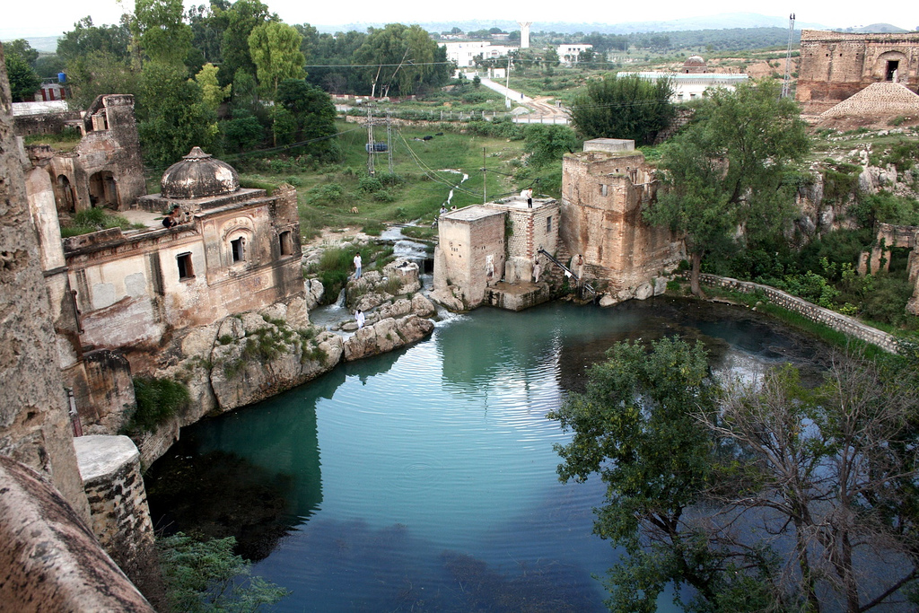  Top: Katas Raj Temples Bottom: Neela Wahn Waterfall | |
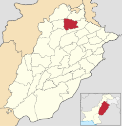 Chakwal is located in the north of Punjab. | |
| Coordinates: 33°40′38″N 72°51′21″E | |
| Country | |
| Province | |
| Division | Rawalpindi |
| Headquarters | Chakwal |
| Tehsils (3) | |
| Government | |
| • Type | District Administration |
| • Deputy Commissioner | Bilal Hasham |
| • District Police Officer | N/A |
| • District Health Officer | N/A |
| Area | |
| • Total | 6,524 km2 (2,519 sq mi) |
| Population (2017)[1] | |
| • Total | 1,495,463 |
| • Density | 230/km2 (590/sq mi) |
| Time zone | UTC+5 (PST) |
| Main language(s) | Punjabi |
| Website | chakwal |
History
During British rule, Chakwal was a tehsil of Jhelum district, the population according to the 1891 census of India was 164,912 which had fallen to 160,316 in 1901. It contained the towns of Chakwal and Bhaun and 248 villages. The land revenue and cesses amounted in 1903-4 to 3–300,000.[3] The predominantly Muslim population supported Muslim League and Pakistan Movement. After the independence of Pakistan in 1947, the minority Hindus and Sikhs migrated to India while the Muslims refugees from India settled down in the area of Chakwal later it was upgraded as a District on 1st of July 1985.
Administrative divisions
The district of Chakwal, which covers an area of 6,524 km2,[4] is subdivided into five tehsils.[5] These tehsils were formerly part of neighbouring districts:[6]: 1
- Chakwal Tehsil was annexed from Jhelum District and made part of the newly formed Chakwal District.
- Choa Saidan Shah was carved out of sub-division Pind Dadan Khan of Jhelum District and was amalgamated with sub-division Chakwal. Choa Saidan Shah was upgraded to the level of a sub-division in 1993.
The district is administratively subdivided into three tehsils and 45 union councils.[7]
| Name of tehsil | No. of union councils | No. of villages | No. of public schools | No. of police stations | No. of post offices | Parent tehsil |
|---|---|---|---|---|---|---|
| Chakwal | 30 | 207 | 523 | 5 | 48 | Chakwal |
| Choa Saidan Shah | 7 | 47 | 96 | 1 | 14 | Chakwal |
| Kallar Kahar | 8 | 72 | 148 | 1 | 15 | Chakwal |
| Total | 45 | 326 | 767 | 7 | 77 |
Constituencies
There is one district council, one municipal committees — Chakwal — and two town committees — Choa Saidan Shah and Kallar Kahar.
The district is represented in the National Assembly by two constituencies: NA-60 and NA-61. The district is represented in the provincial assembly by four elected MPAs and in National Assembly by two MNAs who represent the following constituencies:[8]
| Constituency | MPA | Party[9][10] |
|---|---|---|
| (PP-21) | Raja Yasir Hamayun Sarfaraz | Pakistan Tehreek-e-Insaf |
| (PP-22) | Tanveer Aslam Malik | Pakistan Muslim League (N) |
| (PP-23) | Sardar Aftab Khan | Pakistan Tehreek-e-Insaf |
| (PP-24) | Ammar Yasir | Pakistan Muslim League (Q) |
| (NA-64) | Sardar Zulfiqar Ali Khan | Pakistan Tehreek-e-Insaf |
| (NA-65) | Choudari Perwaiz Ilahi | Pakistan Muslim League (Q) |
Geography
Chakwal district borders the districts of Rawalpindi and Attock in the north, Jhelum in the east, Khushab in the south and Mianwali in the west. The total area of Chakwal district is 6,609 square kilometres, which is equivalent to 1,652,443 acres (6,687.20 km2).
The southern portion runs up into the Salt Range and includes the Chail peak, 3,701 feet (1,128 m) above the sea, the highest point in the district. Between this and the Sohan river, which follows more or less the northern boundary, the country consists of what was once a fairly level plain, sloping down from 2,000 feet (610 m) at the foot of the hills to 1,400 feet (430 m) in the neighbourhood of the Sohan; the surface is now much cut up by ravines and is very difficult to travel over.[3]
Demography
At the time of the 2017 census the district had a population of 1,495,463, of which 723,178 were males and 772,166 females. Rural population is 1,211,855 (81.03%) while the urban population is 283,608 (18.96%). The literacy rate was 74.64% for the population 10 years and above: 84.64% for males and 65.57% for females. Muslims made up almost the entire population with 99.67%, with the minorities being 3,700 Christians and 960 Ahmadis. Hindus number around 190.[1]
At the time of the 2017 census, 93.35% of the population spoke Punjabi, 4.40% Pashto and 1.63% Urdu as their first language.[1]
The local Punjabi dialects are Dhani[11] and Awankari.[12]
Education
Chakwal has a total of 1,199 government schools out of which 52 percent (627 schools) are for female students. The district has an enrollment of 181,574 in public sector schools.[13]
Educational institutions
Educational institutions in the Chakwal District include:
- Government Post Graduate College (Chakwal)
- University Of Chakwal
Notable people
- Yahya Khan, former President of Pakistan, was born at Chakwal city in 1917.
- Manmohan Singh, former Prime Minister of India, was born in Gah village formerly part of Jhelum District
- Khudadad Khan, VC, British Indian Army.
- Malik Nur Khan, Nur Khan, was a three-star air officer, politician, sports administrator, and the Commander-in-Chief of the Pakistan Air Force, serving under President Ayub Khan from 1965 until 1969.
- Muhammad Safdar, Lt. General Muhammad Safdar is the former Governor of Punjab, having served from 1999 to 2001. He has previously also served as the ambassador to Morocco and the Vice-Chancellor of the University of Punjab till 1993.
- Colonel Imam – Brigadier Sultan Amir Tarar was a one-star rank army general in the Pakistan Army, member of Special Service Group (SSG) of the army and an intelligence officer of the Inter-Services Intelligence (ISI).
See also
- Chakwal
- Rawalpindi Division
- Chakwal railway station
- North Western State Railway
- Districts of Pakistan
- Punjab, Pakistan
- Mandra–Bhaun Railway
- Swaik Lake (Khandowa Lake)
References
- "Chakwal district - 2017 census". pbs.gov.pk. Pakistan Bureau of Statistics. 2017.
{{cite web}}: CS1 maint: url-status (link) - "Chakwal – Punjab Portal". Retrieved 17 December 2016.
- Imperial Gazetteer of India, v. 10, p. 126. Dsal.uchicago.edu. Retrieved on 21 April 2012.
- Official Website of Chakwal District Archived 3 July 2009 at the Wayback Machine
- List to tehsils and districts Archived 1 January 2007 at the Wayback Machine
- 1998 District Census report of Chakwal. Census publication. Vol. 77. Islamabad: Population Census Organization, Statistics Division, Government of Pakistan. 2000.
- Tehsils & Unions in the District of Chakwal Archived 24 January 2008 at the Wayback Machine. Nrb.gov.pk. Retrieved on 21 April 2012.
- CHAKWAL (PP-20 to PP-23) – Website of the Provincial Assembly of the Punjab
- "PML-N wins Chakwal by-polls with thumping majority". Retrieved 8 March 2018.
- Chakwal district falls into PML-N's fold, retrieved 17 September 2015
- Masica, Colon P. (9 September 1993). The Indo-Aryan Languages. Cambridge University Press. p. 19. ISBN 0521299446.
- Rensch, Calvin R. (1992). "The Language Environment of Hindko-Speaking People". In O'Leary, Clare F.; Rensch, Calvin R.; Hallberg, Calinda E. (eds.). Hindko and Gujari. Sociolinguistic Survey of Northern Pakistan. Islamabad: National Institute of Pakistan Studies, Quaid-i-Azam University and Summer Institute of Linguistics. p. 7. ISBN 969-8023-13-5.
- "Punjab Annual Schools Census Data 2014-15". Archived from the original on 22 August 2016. Retrieved 22 August 2016.
Bibliography
- University of Engineering and Technology. Centre of Excellence in Water Resources Engineering; Pakistan Science Foundation (1979), National Seminar on Land and Water Resources Development of Barani Areas, [July 21-24, 1979], The University of Wisconsin, ISBN 978-01-9023-806-3
External links
Places adjacent to Chakwal District | ||||||||||||||||
|---|---|---|---|---|---|---|---|---|---|---|---|---|---|---|---|---|
| ||||||||||||||||
Districts of Punjab, Pakistan | ||
|---|---|---|
Provincial capital: Lahore | ||
| Bahawalpur |  | |
| Dera Ghazi Khan | ||
| Faisalabad | ||
| Gujranwala |
| |
| Gujrat |
| |
| Lahore | ||
| Multan | ||
| Rawalpindi |
| |
| Sahiwal | ||
| Sargodha | ||
Authority control | |
|---|---|
| General |
|
| National libraries | |
На других языках
[de] Chakwal (Distrikt)
Der Distrikt Chakwal ist ein Verwaltungsdistrikt in Pakistan in der Provinz Punjab. Sitz der Distriktverwaltung ist die gleichnamige Stadt Chakwal.- [en] Chakwal District
[ru] Чаквал (округ)
Чаквал (урду ضِلع چکوال, англ. Chakwal District) — один из 36 округов пакистанской провинции Пенджаб. Административный центр — город Чаквал.Другой контент может иметь иную лицензию. Перед использованием материалов сайта WikiSort.org внимательно изучите правила лицензирования конкретных элементов наполнения сайта.
WikiSort.org - проект по пересортировке и дополнению контента Википедии