world.wikisort.org - Norway
Sør-Aurdal is a municipality in Innlandet county, Norway. It is located in the traditional district of Valdres. The administrative centre of the municipality is the village of Bagn. Other villages in the municipality include Begna, Hedalen, and Begnadalen.[3]
Sør-Aurdal kommune | |
|---|---|
Municipality | |
 View of Smedlund in Sør-Aurdal | |
 Flag  Coat of arms  Innlandet within Norway | |
 Sør-Aurdal within Innlandet | |
| Coordinates: 60°41′47″N 9°39′32″E | |
| Country | Norway |
| County | Innlandet |
| District | Valdres |
| Established | 1 Jan 1838 |
| • Created as | Formannskapsdistrikt |
| Administrative centre | Bagn |
| Government | |
| • Mayor (2019) | Marit Hougsrud (Sp) |
| Area | |
| • Total | 1,109.05 km2 (428.21 sq mi) |
| • Land | 1,068.24 km2 (412.45 sq mi) |
| • Water | 40.81 km2 (15.76 sq mi) 3.7% |
| • Rank | #101 in Norway |
| Population (2022) | |
| • Total | 2,889 |
| • Rank | #231 in Norway |
| • Density | 2.7/km2 (7/sq mi) |
| • Change (10 years) | |
| Demonym | Søraurdøl[1] |
| Official language | |
| • Norwegian form | Neutral |
| Time zone | UTC+01:00 (CET) |
| • Summer (DST) | UTC+02:00 (CEST) |
| ISO 3166 code | NO-3449 |
| Website | Official website |
The 1,109-square-kilometre (428 sq mi) municipality is the 101st largest by area out of the 356 municipalities in Norway. Sør-Aurdal is the 231st most populous municipality in Norway with a population of 2,889. The municipality's population density is 2.7 inhabitants per square kilometre (7.0/sq mi) and its population has decreased by 8.4% over the previous 10-year period.[4][5]
General information

The parish of Søndre Aurdal was established as a municipality on 1 January 1838 (see formannskapsdistrikt law). On 1 January 1894, the new Etnedal Municipality was established by merging the eastern valley area of Nordre Etnedal (population: 362) from the neighboring Nordre Aurdal municipality and the Søndre Etnedal area (population: 1,331) from the neighboring municipality of Søndre Aurdal. Then on 1 January 1984, the unpopulated northern side of the Makalaus mountain was transferred from Sør-Aurdal to Nord-Aurdal.[6][3]
Name
The municipality (and parish) was named after the valley in which it is located. The Old Norse form of the valley name was Aurardalr. The first element is the genitive case of an old river name Aur (now called Bøaelva) and the last element is dalr which means "valley" or "dale". The old river name is derived from aurr which means "gravel". Originally the municipality was named Søndre Aurdal. The name was changed from Søndre Aurdal to Sør-Aurdal in the early 20th century. Both søndre and sør- mean "south" (more specifically, "søndre" means "southern"), so the name Sør-Aurdal means "(the) southern (part of) Aurdal". (The Church of Norway parish of Aurdal was divided into two in 1805, just over 30 years before the municipality was established in 1838.)[7]
Coat of arms
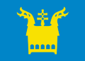
The coat of arms was granted by royal decree on 9 February 1990. It is blue with gold silhouette of the gilt-copper medieval reliquary (chasse) that is based on the one found in the Hedal Stave Church except that this one has five blue arches which are inspired by the arches on a similar medieval chasse from the nearby medieval St. Thomas Church at Filefjell (now in the Bergen Museum) and representing the five Church of Norway parishes of the municipality (Bagn, Reinli, Hedalen, Bruflat, and Begnadalen). It also has two dragon heads in the design since Sør-Aurdal is one of only two municipalities in Norway that have two stave churches that are still in use. The color blue was chosen to represent the two river systems in the municipality that were historically important for the logging industry and sawmills in Sør-Aurdal.[8][9]
Churches
The Church of Norway has five parishes (sokn) within the municipality of Sør-Aurdal. It is part of the Valdres prosti (deanery) in the Diocese of Hamar.
| Parish (sokn) | Church name | Location of the church | Year built |
|---|---|---|---|
| Bagn | Bagn Church | Bagn | 1736 |
| Begnadalen | Begnadalen Church | Begnadalen | 1964 |
| Hedalen | Hedalen Stave Church | Hedalen | c. 1165 |
| Leirskogen | Leirskogen Church | Leirskogen | 1924 |
| Reinli | Reinli Stave Church | Reinli | 1326 |
| Reinli Chapel | Reinli | 1964 |
Geography
Sør-Aurdal municipality is bordered on the north by the municipalities of Nord-Aurdal and Etnedal, on the northeast by Nordre Land, on the east by Søndre Land (all of which are in Innlandet county). It is also bordered on the south by Ringerike and Flå municipalities, and on the west by Nesbyen and Gol municipalities (all of which are in Viken).
Sør-Aurdal is part of the traditional district of Valdres in central, southern Norway, situated between the Gudbrandsdal and Hallingdal valleys. Sør-Aurdal includes parts of several smaller valleys including Begnadalen, Hedalen, Vassfaret, and Vidalen. The river Begna is the main river flowing through the municipality.
History
| Ancestry | Number |
|---|---|
| 28 | |
| 20 | |
| 19 | |
| 17 | |
| 16 |
Reinli Stave Church (built 1190-1250) is the third church on the same location in Reinli. A new tower was added in 1685 and the building was reconditioned by the Society for Preservation of Ancient Buildings in 1885.[11]
Olaf Haraldsson traveled through Valdres in 1023, and also visited Reinli. It is assumed, then, that there was a pagan temple at the same location before the first church, some time before the year 1000.[11]
Hedal Stave Church was built after 1160 and in 1699 it was rebuilt and changed. An old legend says the valley was abandoned during the Black Death and the church later discovered by a bear hunter. A hide is hanging in the church, although now there is only a small part left as visitors have cut away pieces over the years.[11]
Government
All municipalities in Norway, including Sør-Aurdal, are responsible for primary education (through 10th grade), outpatient health services, senior citizen services, unemployment and other social services, zoning, economic development, and municipal roads. The municipality is governed by a municipal council of elected representatives, which in turn elects a mayor.[12] The municipality falls under the Vestre Innlandet District Court and the Eidsivating Court of Appeal.
Municipal council
The municipal council (Kommunestyre) of Sør-Aurdal is made up of 19 representatives that are elected to four year terms. The party breakdown of the council is as follows:
| Party Name (in Norwegian) | Number of representatives | |
|---|---|---|
| Labour Party (Arbeiderpartiet) | 6 | |
| Progress Party (Fremskrittspartiet) | 1 | |
| Conservative Party (Høyre) | 2 | |
| Centre Party (Senterpartiet) | 9 | |
| Cross-party municipal list (Tverrpolitisk Kommuneliste) | 1 | |
| Total number of members: | 19 | |
| Party Name (in Norwegian) | Number of representatives | |
|---|---|---|
| Labour Party (Arbeiderpartiet) | 6 | |
| Progress Party (Fremskrittspartiet) | 1 | |
| Conservative Party (Høyre) | 2 | |
| Christian Democratic Party (Kristelig Folkeparti) | 2 | |
| Centre Party (Senterpartiet) | 12 | |
| Cross-party municipal list (Tverrpolitisk Kommuneliste) | 2 | |
| Total number of members: | 25 | |
| Party Name (in Norwegian) | Number of representatives | |
|---|---|---|
| Labour Party (Arbeiderpartiet) | 8 | |
| Progress Party (Fremskrittspartiet) | 3 | |
| Conservative Party (Høyre) | 2 | |
| Christian Democratic Party (Kristelig Folkeparti) | 1 | |
| Centre Party (Senterpartiet) | 8 | |
| Cross-party municipal list (Tverrpolitisk Kommuneliste) | 3 | |
| Total number of members: | 25 | |
| Party Name (in Norwegian) | Number of representatives | |
|---|---|---|
| Labour Party (Arbeiderpartiet) | 8 | |
| Progress Party (Fremskrittspartiet) | 4 | |
| Conservative Party (Høyre) | 1 | |
| Christian Democratic Party (Kristelig Folkeparti) | 1 | |
| Centre Party (Senterpartiet) | 8 | |
| Cross-party municipal list (Tverrpolitisk Kommuneliste) | 3 | |
| Total number of members: | 25 | |
| Party Name (in Norwegian) | Number of representatives | |
|---|---|---|
| Labour Party (Arbeiderpartiet) | 10 | |
| Conservative Party (Høyre) | 2 | |
| Christian Democratic Party (Kristelig Folkeparti) | 2 | |
| Centre Party (Senterpartiet) | 5 | |
| Socialist Left Party (Sosialistisk Venstreparti) | 2 | |
| Cross-party municipal list (Tverrpolitisk Kommuneliste) | 4 | |
| Total number of members: | 25 | |
| Party Name (in Norwegian) | Number of representatives | |
|---|---|---|
| Labour Party (Arbeiderpartiet) | 11 | |
| Conservative Party (Høyre) | 3 | |
| Christian Democratic Party (Kristelig Folkeparti) | 2 | |
| Centre Party (Senterpartiet) | 3 | |
| Cross-party municipal list (Tverrpolitisk Kommuneliste) | 6 | |
| Total number of members: | 25 | |
| Party Name (in Norwegian) | Number of representatives | |
|---|---|---|
| Labour Party (Arbeiderpartiet) | 10 | |
| Conservative Party (Høyre) | 3 | |
| Socialist Left Party (Sosialistisk Venstreparti) | 1 | |
| Joint list of the Centre Party (Senterpartiet) and the Christian Democratic Party (Kristelig Folkeparti) | 9 | |
| Cross-party municipal list (Tverrpolitisk Kommuneliste) | 2 | |
| Total number of members: | 25 | |
| Party Name (in Norwegian) | Number of representatives | |
|---|---|---|
| Labour Party (Arbeiderpartiet) | 9 | |
| Christian Democratic Party (Kristelig Folkeparti) | 1 | |
| Socialist Left Party (Sosialistisk Venstreparti) | 2 | |
| Joint list of the Conservative Party (Høyre), Centre Party (Senterpartiet), and Liberal Party (Venstre) | 13 | |
| Total number of members: | 25 | |
| Party Name (in Norwegian) | Number of representatives | |
|---|---|---|
| Labour Party (Arbeiderpartiet) | 13 | |
| Conservative Party (Høyre) | 3 | |
| Christian Democratic Party (Kristelig Folkeparti) | 2 | |
| Centre Party (Senterpartiet) | 6 | |
| Socialist Left Party (Sosialistisk Venstreparti) | 1 | |
| Total number of members: | 25 | |
| Party Name (in Norwegian) | Number of representatives | |
|---|---|---|
| Labour Party (Arbeiderpartiet) | 14 | |
| Conservative Party (Høyre) | 3 | |
| Christian Democratic Party (Kristelig Folkeparti) | 2 | |
| Centre Party (Senterpartiet) | 5 | |
| Liberal Party (Venstre) | 1 | |
| Total number of members: | 25 | |
| Party Name (in Norwegian) | Number of representatives | |
|---|---|---|
| Labour Party (Arbeiderpartiet) | 13 | |
| Conservative Party (Høyre) | 4 | |
| Christian Democratic Party (Kristelig Folkeparti) | 2 | |
| Centre Party (Senterpartiet) | 5 | |
| Liberal Party (Venstre) | 1 | |
| Total number of members: | 25 | |
| Party Name (in Norwegian) | Number of representatives | |
|---|---|---|
| Labour Party (Arbeiderpartiet) | 13 | |
| Conservative Party (Høyre) | 1 | |
| Christian Democratic Party (Kristelig Folkeparti) | 3 | |
| Centre Party (Senterpartiet) | 6 | |
| Socialist Left Party (Sosialistisk Venstreparti) | 1 | |
| Liberal Party (Venstre) | 1 | |
| Total number of members: | 25 | |
| Party Name (in Norwegian) | Number of representatives | |
|---|---|---|
| Labour Party (Arbeiderpartiet) | 14 | |
| Christian Democratic Party (Kristelig Folkeparti) | 2 | |
| Liberal Party (Venstre) | 1 | |
| Joint List(s) of Non-Socialist Parties (Borgerlige Felleslister) | 8 | |
| Total number of members: | 25 | |
| Party Name (in Norwegian) | Number of representatives | |
|---|---|---|
| Labour Party (Arbeiderpartiet) | 15 | |
| Christian Democratic Party (Kristelig Folkeparti) | 1 | |
| Joint List(s) of Non-Socialist Parties (Borgerlige Felleslister) | 9 | |
| Total number of members: | 25 | |
| Party Name (in Norwegian) | Number of representatives | |
|---|---|---|
| Labour Party (Arbeiderpartiet) | 15 | |
| Christian Democratic Party (Kristelig Folkeparti) | 1 | |
| Joint List(s) of Non-Socialist Parties (Borgerlige Felleslister) | 8 | |
| Local List(s) (Lokale lister) | 1 | |
| Total number of members: | 25 | |
| Party Name (in Norwegian) | Number of representatives | |
|---|---|---|
| Labour Party (Arbeiderpartiet) | 14 | |
| Christian Democratic Party (Kristelig Folkeparti) | 2 | |
| Joint List(s) of Non-Socialist Parties (Borgerlige Felleslister) | 9 | |
| Total number of members: | 25 | |
| Party Name (in Norwegian) | Number of representatives | |
|---|---|---|
| Labour Party (Arbeiderpartiet) | 18 | |
| Joint List(s) of Non-Socialist Parties (Borgerlige Felleslister) | 14 | |
| Total number of members: | 32 | |
| Party Name (in Norwegian) | Number of representatives | |
|---|---|---|
| Labour Party (Arbeiderpartiet) | 14 | |
| Communist Party (Kommunistiske Parti) | 3 | |
| Farmers' Party (Bondepartiet) | 4 | |
| Joint list of the Liberal Party (Venstre) and the Radical People's Party (Radikale Folkepartiet) | 2 | |
| Joint List(s) of Non-Socialist Parties (Borgerlige Felleslister) | 9 | |
| Total number of members: | 32 | |
| Party Name (in Norwegian) | Number of representatives | |
|---|---|---|
| Labour Party (Arbeiderpartiet) | 13 | |
| Communist Party (Kommunistiske Parti) | 3 | |
| Joint List(s) of Non-Socialist Parties (Borgerlige Felleslister) | 7 | |
| Local List(s) (Lokale lister) | 9 | |
| Total number of members: | 32 | |
| Party Name (in Norwegian) | Number of representatives | |
|---|---|---|
| Labour Party (Arbeiderpartiet) | 14 | |
| Joint List(s) of Non-Socialist Parties (Borgerlige Felleslister) | 14 | |
| Local List(s) (Lokale lister) | 4 | |
| Total number of members: | 32 | |
| Note: Due to the German occupation of Norway during World War II, no elections were held for new municipal councils until after the war ended in 1945. | ||
Mayors
The mayors of Sør-Aurdal (incomplete list):
- 1945: Arne H. Grøv (V)
- 1946-1963: Harald Bakken (Ap)
- 1964-1981: Hallgrim Tronrud (Ap)
- 1982-1991: Kristoffer Storruste (Ap)
- 1992-1999: Svein Thorsrud (Sp)
- 1999-2007: Knut Torgersen (Ap)
- 2007–2019: Kåre Helland (Sp)
- 2019–present: Marit Hougsrud (Sp)
Media gallery
 Reinli Stavkyrkje
 Hedal Stavkyrkje
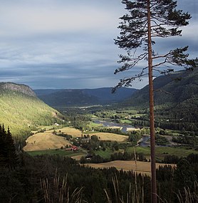 Begnadalen
 Svartsetera, Bagn Bygdesamling


Attractions
- Bagn Bygdesamling is a museum that is associated with Valdres Folkemuseum. It is located 8 kilometres (5.0 mi) south of Bagn. It consists of twelve log houses and a building for permanent displays. A part of the museum is at Sandviken and the farm is Bagnsbergatn.
- Bautahaugen Samlinger is another museum that is also associated with Valdres Folkemuseum. It is located in the middle of Hedalen. It consists of a collection of houses and items from Hedalen. The Hedal Stave Church is located just nearby.
Notable residents
- Ola Hermundsen Berge (1768 in Sør-Aurdal - 1825), a Norwegian folk artist and rose painter
- Hans Jacob Stabel (1769–1836), a priest in Sør-Aurdal from 1806; member of the constitutional assembly at Eidsvoll in 1814
- Haldor Boen (1851 in Sør-Aurdal – 1912), an American congressman from Minnesota
- Mikkjel Fønhus (1874 in Sør-Aurdal - 1973), a journalist, novelist and short story writer about animals in the wilderness
- Sigurd Islandsmoen (1881 in Bagn – 1964), a composer of music for the Church of Norway
- Rolf Andvord (1890 in Sør-Aurdal – 1976), a Norwegian jurist and diplomat
- Per Juvkam (1907 in Sør-Aurdal – 2003), a Lutheran Bishop of Bjørgvin 1961-1977
- Ruth Lagesen (1914 in Bagn – 2005), a Norwegian pianist and conductor
- Morten Bakke (born 1968 in Hedalen), a retired football goalkeeper with over 300 club caps
References
- "Navn på steder og personer: Innbyggjarnamn" (in Norwegian). Språkrådet.
- "Forskrift om målvedtak i kommunar og fylkeskommunar" (in Norwegian). Lovdata.no.
- Thorsnæs, Geir, ed. (4 July 2022). "Sør-Aurdal". Store norske leksikon (in Norwegian). Kunnskapsforlaget. Retrieved 25 September 2022.
- Statistisk sentralbyrå (2022). "Table: 06913: Population 1 January and population changes during the calendar year (M)" (in Norwegian).
- Statistisk sentralbyrå (2022). "09280: Area of land and fresh water (km²) (M)" (in Norwegian).
- Jukvam, Dag (1999). "Historisk oversikt over endringer i kommune- og fylkesinndelingen" (PDF) (in Norwegian). Statistisk sentralbyrå.
- Rygh, Oluf (1900). Norske gaardnavne: Kristians amt (Anden halvdel) (in Norwegian) (4 ed.). Kristiania, Norge: W. C. Fabritius & sønners bogtrikkeri. p. 251.
- Bakgrunnshistorien til kommunevåpnet for Sør-Aurdal (in Norwegian). Sør-Aurdal kommune. Retrieved 3 January 2009.
- "Civic heraldry of Norway - Norske Kommunevåpen". Heraldry of the World. Retrieved 25 September 2022.
- "Immigrants and Norwegian-born to immigrant parents, by immigration category, country background and percentages of the population". ssb.no. Archived from the original on 2 July 2015. Retrieved 29 June 2015.
- Stagg, Frank Noel (1956). East Norway and its Frontier. George Allen & Unwin, Ltd.
- Hansen, Tore, ed. (12 May 2016). "kommunestyre". Store norske leksikon (in Norwegian). Kunnskapsforlaget. Retrieved 30 January 2022.
- "Tall for Norge: Kommunestyrevalg 2019 - Innlandet". Valg Direktoratet. Retrieved 25 September 2022.
- "Tall for Norge: Kommunestyrevalg 2015 - Oppland". Valg Direktoratet.
- "Table: 04813: Members of the local councils, by party/electoral list at the Municipal Council election (M)" (in Norwegian). Statistics Norway.
- "Tall for Norge: Kommunestyrevalg 2011 - Oppland". Valg Direktoratet.
- "Kommunestyrevalget 1999" (PDF) (in Norwegian). Oslo-Kongsvinger, Norge: Statistisk sentralbyrå. 2000. ISBN 8253748531. ISSN 0332-8023.
- "Kommunestyrevalget 1995" (PDF) (in Norwegian). Oslo-Kongsvinger, Norge: Statistisk sentralbyrå. 1996. ISBN 8253743351. ISSN 0332-8023.
- "Kommunestyrevalget 1991" (PDF) (in Norwegian). Oslo-Kongsvinger, Norge: Statistisk sentralbyrå. 1993. ISBN 8253737939. ISSN 0332-8023.
- "Kommunestyrevalget 1987" (PDF) (in Norwegian). Oslo-Kongsvinger, Norge: Statistisk sentralbyrå. 1988. ISBN 8253726325. ISSN 0332-8023.
- "Kommunestyrevalget 1983" (PDF) (in Norwegian). Oslo-Kongsvinger, Norge: Statistisk sentralbyrå. 1984. ISBN 8253720378. ISSN 0332-8023.
- "Kommunestyrevalget 1979" (PDF) (in Norwegian). Oslo, Norge: Statistisk sentralbyrå. 1979. ISBN 8253710836. ISSN 0332-8023.
- "Kommunevalgene 1975" (PDF) (in Norwegian). Oslo, Norge: Statistisk sentralbyrå. 1977. ISBN 8253705646.
- "Kommunevalgene 1972" (PDF) (in Norwegian). Oslo, Norge: Statistisk sentralbyrå. 1973. ISBN 8253701144.
- "Kommunevalgene 1967" (PDF) (in Norwegian). Oslo, Norge: Statistisk sentralbyrå. 1967.
- "Kommunevalgene 1963" (PDF) (in Norwegian). Oslo, Norge: Statistisk sentralbyrå. 1964.
- "Kommunevalgene og Ordførervalgene 1959" (PDF) (in Norwegian). Oslo, Norge: Statistisk sentralbyrå. 1960.
- "Kommunevalgene og Ordførervalgene 1955" (PDF) (in Norwegian). Oslo, Norge: Statistisk sentralbyrå. 1957.
- "Kommunevalgene og Ordførervalgene 1951" (PDF) (in Norwegian). Oslo: Statistisk sentralbyrå. 1952.
- "Kommunevalgene og Ordførervalgene 1947" (PDF) (in Norwegian). Oslo: Statistisk sentralbyrå. 1948.
- "Kommunevalgene og Ordførervalgene 1945" (PDF) (in Norwegian). Oslo: Statistisk sentralbyrå. 1947.
- "Kommunevalgene og Ordførervalgene 1937" (PDF) (in Norwegian). Oslo: Statistisk sentralbyrå. 1938.
External links
- Municipal fact sheet from Statistics Norway (in Norwegian)
 Oppland travel guide from Wikivoyage
- Map of Sør-Aurdal municipality in Kulturnett.no (in Norwegian)
- Mikkjel Fønhus biography from Dagbladet (in Norwegian)
Innlandet county, Norway | |||||||||||||||||||||
|---|---|---|---|---|---|---|---|---|---|---|---|---|---|---|---|---|---|---|---|---|---|
| |||||||||||||||||||||
 | Towns and cities |
|  | ||||||||||||||||||
| Municipalities |
| ||||||||||||||||||||
На других языках
[de] Sør-Aurdal
Sør-Aurdal ist eine Kommune im norwegischen Fylke Innlandet. Die Kommune hat 2889 Einwohner (Stand: 1. Januar 2022). Verwaltungssitz ist die Ortschaft Bagn.- [en] Sør-Aurdal
[ru] Сёр-Эурдал
Сёр-Эурдал (норв. Sør-Aurdal) — коммуна в губернии Оппланн в Норвегии. Административный центр коммуны — город Багн. Официальный язык коммуны — нейтральный[1]. Население коммуны на 2007 год составляло 3176 чел. Площадь коммуны Сёр-Эурдал — 1108,99 км², код-идентификатор — 0540.Другой контент может иметь иную лицензию. Перед использованием материалов сайта WikiSort.org внимательно изучите правила лицензирования конкретных элементов наполнения сайта.
WikiSort.org - проект по пересортировке и дополнению контента Википедии