world.wikisort.org - Norway
Os is a municipality in Innlandet county, Norway. It is located in the traditional district of Østerdalen. The administrative centre of the municipality is the village of Os i Østerdalen. The municipality is located to the west of the municipality of Røros and to the south of the municipalities of Midtre Gauldal and Holtålen in Trøndelag county. In Innlandet county, Os is located to the west of the municipality of Tolga and to the north of the municipality of Engerdal.[3]
Os kommune | |
|---|---|
Municipality | |
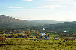
 View of Os i Østerdalen | |
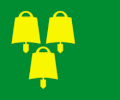
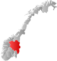
 Flag  Coat of arms  Innlandet within Norway | |
 Os within Innlandet | |
| Coordinates: 62°28′34″N 11°14′35″E | |
| Country | Norway |
| County | Innlandet |
| District | Østerdalen |
| Established | 1 July 1926 |
| • Preceded by | Tolga Municipality |
| Disestablished | 1 Jan 1966 |
| • Succeeded by | Tolga-Os Municipality |
| Re-established | 1 Jan 1976 |
| • Preceded by | Tolga-Os Municipality |
| Administrative centre | Os i Østerdalen |
| Government | |
| • Mayor (2015) | Runa Finborud (Sp) |
| Area | |
| • Total | 1,040.32 km2 (401.67 sq mi) |
| • Land | 1,006.65 km2 (388.67 sq mi) |
| • Water | 33.67 km2 (13.00 sq mi) 3.2%% |
| • Rank | #110 in Norway |
| Population (2022) | |
| • Total | 1,855 |
| • Rank | #288 in Norway |
| • Density | 1.8/km2 (5/sq mi) |
| • Change (10 years) | |
| Demonym | Osing[1] |
| Official language | |
| • Norwegian form | Neutral |
| Time zone | UTC+01:00 (CET) |
| • Summer (DST) | UTC+02:00 (CEST) |
| ISO 3166 code | NO-3430 |
| Website | Official website |
The 1,040-square-kilometre (400 sq mi) municipality is the 110th largest by area out of the 356 municipalities in Norway. Os is the 288th most populous municipality in Norway with a population of 1,855. The municipality's population density is 1.8 inhabitants per square kilometre (4.7/sq mi) and its population has decreased by 9.1% over the previous 10-year period.[4][5]
General information

The parish of Os was historically part of Tolga Municipality. On 1 July 1926 the parish of Os (population: 1,936) was separated from Tolga to become a separate municipality. In 1927, a small area of Tolga (population: 18) was transferred to the municipality of Os. During the 1960s, there were many municipal mergers across Norway due to the work of the Schei Committee. On 1 January 1966, the municipality of Os (population: 2,015) was merged with the municipality of Tolga (population: 1,944) to form the new municipality of Tolga-Os. This arrangement was not well-liked by the local residents so after a few years, the municipalities began to ask to undo the merger. On 1 January 1976, the merger was reversed and the municipalities of Os (population: 1,859) and Tolga (population: 1,865) were re-established using their old boundaries.[6]
Name
The municipality (originally the parish) is named after the old Os farm (Old Norse: Óss), since the first Os Church was built here in 1703. The name is identical with the word óss which means "mouth of a river" (here it is referring to the Vangrøfta river running out into the Glomma river).[3][7]
Coat of arms
The coat of arms was granted on 17 December 1992. The arms show three gold cowbells on a green background. It symbolizes the traditional and modern businesses in the municipality.[3]
Churches
The Church of Norway has three parishes (sokn) within the municipality of Os. It is part of the Nord-Østerdal prosti (deanery) in the Diocese of Hamar.
| Parish (sokn) | Church name | Location of the church | Year built |
|---|---|---|---|
| Dalsbygda | Dalsbygda Church | Dalsbygda | 1960 |
| Narbuvoll | Narbuvoll Church | Narbuvoll | 1862 |
| Tufsingdalen Church | Tufsingdal | 1920 | |
| Os | Os Church | Os i Østerdalen | 1862 |
Government
All municipalities in Norway, including Os, are responsible for primary education (through 10th grade), outpatient health services, senior citizen services, unemployment and other social services, zoning, economic development, and municipal roads. The municipality is governed by a municipal council of elected representatives, which in turn elects a mayor.[8] The municipality falls under the Østre Innlandet District Court and the Eidsivating Court of Appeal.
Municipal council
The municipal council (Kommunestyre) of Os is made up of 15 representatives that are elected to four year terms. The party breakdown of the council is as follows:
| Party Name (in Norwegian) | Number of representatives | |
|---|---|---|
| Labour Party (Arbeiderpartiet) | 4 | |
| Christian Democratic Party (Kristelig Folkeparti) | 1 | |
| Centre Party (Senterpartiet) | 8 | |
| Socialist Left Party (Sosialistisk Venstreparti) | 2 | |
| Total number of members: | 15 | |
| Party Name (in Norwegian) | Number of representatives | |
|---|---|---|
| Labour Party (Arbeiderpartiet) | 5 | |
| Christian Democratic Party (Kristelig Folkeparti) | 1 | |
| Centre Party (Senterpartiet) | 9 | |
| Socialist Left Party (Sosialistisk Venstreparti) | 2 | |
| Total number of members: | 17 | |
| Party Name (in Norwegian) | Number of representatives | |
|---|---|---|
| Labour Party (Arbeiderpartiet) | 6 | |
| Centre Party (Senterpartiet) | 13 | |
| Socialist Left Party (Sosialistisk Venstreparti) | 2 | |
| Total number of members: | 21 | |
| Party Name (in Norwegian) | Number of representatives | |
|---|---|---|
| Labour Party (Arbeiderpartiet) | 8 | |
| Centre Party (Senterpartiet) | 10 | |
| Socialist Left Party (Sosialistisk Venstreparti) | 3 | |
| Total number of members: | 21 | |
| Party Name (in Norwegian) | Number of representatives | |
|---|---|---|
| Labour Party (Arbeiderpartiet) | 8 | |
| Christian Democratic Party (Kristelig Folkeparti) | 1 | |
| Centre Party (Senterpartiet) | 9 | |
| Socialist Left Party (Sosialistisk Venstreparti) | 3 | |
| Total number of members: | 21 | |
| Party Name (in Norwegian) | Number of representatives | |
|---|---|---|
| Labour Party (Arbeiderpartiet) | 7 | |
| Christian Democratic Party (Kristelig Folkeparti) | 1 | |
| Centre Party (Senterpartiet) | 11 | |
| Socialist Left Party (Sosialistisk Venstreparti) | 2 | |
| Total number of members: | 21 | |
| Party Name (in Norwegian) | Number of representatives | |
|---|---|---|
| Labour Party (Arbeiderpartiet) | 8 | |
| Christian Democratic Party (Kristelig Folkeparti) | 1 | |
| Centre Party (Senterpartiet) | 10 | |
| Socialist Left Party (Sosialistisk Venstreparti) | 2 | |
| Total number of members: | 21 | |
| Party Name (in Norwegian) | Number of representatives | |
|---|---|---|
| Labour Party (Arbeiderpartiet) | 8 | |
| Christian Democratic Party (Kristelig Folkeparti) | 1 | |
| Centre Party (Senterpartiet) | 9 | |
| Socialist Left Party (Sosialistisk Venstreparti) | 3 | |
| Total number of members: | 21 | |
| Party Name (in Norwegian) | Number of representatives | |
|---|---|---|
| Labour Party (Arbeiderpartiet) | 8 | |
| Christian Democratic Party (Kristelig Folkeparti) | 1 | |
| Centre Party (Senterpartiet) | 6 | |
| Socialist Left Party (Sosialistisk Venstreparti) | 2 | |
| Total number of members: | 17 | |
| Party Name (in Norwegian) | Number of representatives | |
|---|---|---|
| Labour Party (Arbeiderpartiet) | 10 | |
| Christian Democratic Party (Kristelig Folkeparti) | 1 | |
| Centre Party (Senterpartiet) | 6 | |
| Total number of members: | 17 | |
| Party Name (in Norwegian) | Number of representatives | |
|---|---|---|
| Labour Party (Arbeiderpartiet) | 10 | |
| Conservative Party (Høyre) | 1 | |
| Christian Democratic Party (Kristelig Folkeparti) | 1 | |
| Centre Party (Senterpartiet) | 5 | |
| Total number of members: | 17 | |
| Party Name (in Norwegian) | Number of representatives | |
|---|---|---|
| Labour Party (Arbeiderpartiet) | 8 | |
| Christian Democratic Party (Kristelig Folkeparti) | 1 | |
| Centre Party (Senterpartiet) | 8 | |
| Total number of members: | 17 | |
| Party Name (in Norwegian) | Number of representatives | |
|---|---|---|
| Labour Party (Arbeiderpartiet) | 8 | |
| Centre Party (Senterpartiet) | 8 | |
| Liberal Party (Venstre) | 1 | |
| Total number of members: | 17 | |
| Note: On 1 Jan 1966, the municipality became part of Tolga-Os. On 1 Jan 1976, this merger was undone and Os became a separate municipality once again. | ||
| Party Name (in Norwegian) | Number of representatives | |
|---|---|---|
| Labour Party (Arbeiderpartiet) | 8 | |
| Centre Party (Senterpartiet) | 8 | |
| Liberal Party (Venstre) | 1 | |
| Total number of members: | 17 | |
| Party Name (in Norwegian) | Number of representatives | |
|---|---|---|
| Labour Party (Arbeiderpartiet) | 8 | |
| Farmers' Party (Bondepartiet) | 9 | |
| Total number of members: | 17 | |
| Party Name (in Norwegian) | Number of representatives | |
|---|---|---|
| Labour Party (Arbeiderpartiet) | 7 | |
| Farmers' Party (Bondepartiet) | 7 | |
| Liberal Party (Venstre) | 2 | |
| Total number of members: | 16 | |
| Party Name (in Norwegian) | Number of representatives | |
|---|---|---|
| Labour Party (Arbeiderpartiet) | 5 | |
| Communist Party (Kommunistiske Parti) | 1 | |
| Joint List(s) of Non-Socialist Parties (Borgerlige Felleslister) | 10 | |
| Total number of members: | 16 | |
| Party Name (in Norwegian) | Number of representatives | |
|---|---|---|
| Labour Party (Arbeiderpartiet) | 6 | |
| Joint List(s) of Non-Socialist Parties (Borgerlige Felleslister) | 10 | |
| Total number of members: | 16 | |
| Party Name (in Norwegian) | Number of representatives | |
|---|---|---|
| Labour Party (Arbeiderpartiet) | 6 | |
| Joint List(s) of Non-Socialist Parties (Borgerlige Felleslister) | 10 | |
| Total number of members: | 16 | |
| Note: Due to the German occupation of Norway during World War II, no elections were held for new municipal councils until after the war ended in 1945. | ||
Mayor
The mayors of Os (incomplete list):
- 2015–present: Runa Finborud (Sp)
- 2011-2015: Arnfinn Nergård (Sp)
- 2007-2011: Arne Grue (Ap)
- 1995-2007: Arnfinn Nergård (Sp)
Geography
Lakes in the region include Flensjøen, Femunden, and Siksjøen. The mountains Forollhogna and Håmmålsfjellet are located in Os. The large river Glomma runs through the northern part of the municipality.[3]
Notable people
- Arnfinn Nergård (born 1952) is a Norwegian politician, Mayor of Os & county Mayor of Hedmark
Sport
- Annar Ryen (1909 in Os – 1985) a Norwegian cross-country skier
- Viggo Sundmoen (born 1954 in Os) a Norwegian former footballer with 150 club caps
- Randi Langøigjelten (born 1957) a retired Norwegian middle-distance runner
- Therese Johaug (born 1988 in Os) a Norwegian cross-country skier and three-time Olympic medallist
- Jon Aukrust Osmoen (born 1992 in Os) a Norwegian orienteering competitor
References
- "Navn på steder og personer: Innbyggjarnamn" (in Norwegian). Språkrådet.
- "Forskrift om målvedtak i kommunar og fylkeskommunar" (in Norwegian). Lovdata.no.
- Svendsen, Trond Olav, ed. (2021-09-08). "Os (kommune i Nord-Østerdal)". Store norske leksikon (in Norwegian). Kunnskapsforlaget. Retrieved 2022-02-04.
- Statistisk sentralbyrå. "Table: 06913: Population 1 January and population changes during the calendar year (M)" (in Norwegian).
- Statistisk sentralbyrå. "09280: Area of land and fresh water (km²) (M)" (in Norwegian).
- Jukvam, Dag (1999). "Historisk oversikt over endringer i kommune- og fylkesinndelingen" (PDF) (in Norwegian). Statistisk sentralbyrå.
- Rygh, Oluf (1900). Norske gaardnavne: Hedmarkens amt (in Norwegian) (3 ed.). Kristiania, Norge: W. C. Fabritius & sønners bogtrikkeri. pp. 417 and 423.
- Hansen, Tore, ed. (2016-05-12). "kommunestyre". Store norske leksikon (in Norwegian). Kunnskapsforlaget. Retrieved 2022-01-30.
- "Tall for Norge: Kommunestyrevalg 2019 - Innlandet". Valg Direktoratet.
- "Tall for Norge: Kommunestyrevalg 2015 - Innlandet". Valg Direktoratet.
- "Table: 04813: Members of the local councils, by party/electoral list at the Municipal Council election (M)" (in Norwegian). Statistics Norway.
- "Tall for Norge: Kommunestyrevalg 2011 - Innlandet". Valg Direktoratet.
- "Kommunestyrevalget 1995" (PDF) (in Norwegian). Oslo-Kongsvinger: Statistisk sentralbyrå. 1996.
- "Kommunestyrevalget 1991" (PDF) (in Norwegian). Oslo-Kongsvinger: Statistisk sentralbyrå. 1993.
- "Kommunestyrevalget 1987" (PDF) (in Norwegian). Oslo-Kongsvinger: Statistisk sentralbyrå. 1988.
- "Kommunestyrevalget 1983" (PDF) (in Norwegian). Oslo-Kongsvinger: Statistisk sentralbyrå. 1984.
- "Kommunestyrevalget 1979" (PDF) (in Norwegian). Oslo: Statistisk sentralbyrå. 1979.
- "Kommunevalgene 1975" (PDF) (in Norwegian). Oslo: Statistisk sentralbyrå. 1977.
- "Kommunevalgene 1963" (PDF) (in Norwegian). Oslo: Statistisk sentralbyrå. 1964.
- "Kommunevalgene og Ordførervalgene 1959" (PDF) (in Norwegian). Oslo: Statistisk sentralbyrå. 1960.
- "Kommunevalgene og Ordførervalgene 1955" (PDF) (in Norwegian). Oslo: Statistisk sentralbyrå. 1957.
- "Kommunevalgene og Ordførervalgene 1951" (PDF) (in Norwegian). Oslo: Statistisk sentralbyrå. 1952.
- "Kommunevalgene og Ordførervalgene 1947" (PDF) (in Norwegian). Oslo: Statistisk sentralbyrå. 1948.
- "Kommunevalgene og Ordførervalgene 1945" (PDF) (in Norwegian). Oslo: Statistisk sentralbyrå. 1947.
- "Kommunevalgene og Ordførervalgene 1937" (PDF) (in Norwegian). Oslo: Statistisk sentralbyrå. 1938.
External links
 Media related to Os, Innlandet at Wikimedia Commons
 The dictionary definition of Os at Wiktionary
- Municipal fact sheet from Statistics Norway (in Norwegian)
На других языках
[de] Os (Innlandet)
Os ist eine Kommune im norwegischen Fylke Innlandet. Sie liegt im Østerdalen unweit der Bergstadt Røros.- [en] Os, Innlandet
[ru] Ус (Хедмарк)
Ус (норв. Os) — коммуна в губернии Хедмарк в Норвегии. Административный центр коммуны — город Ус. Официальный язык коммуны — нейтральный[1]. Население коммуны на 2007 год составляло 2047 чел. Площадь коммуны Ус — 1040,45 км², код-идентификатор — 0441.Другой контент может иметь иную лицензию. Перед использованием материалов сайта WikiSort.org внимательно изучите правила лицензирования конкретных элементов наполнения сайта.
WikiSort.org - проект по пересортировке и дополнению контента Википедии

