world.wikisort.org - Netherlands
Kampen (Dutch pronunciation: [ˈkɑmpə(n)] (![]() listen)) is a city and municipality in the province of Overijssel, Netherlands. A member of the former Hanseatic League, it is located at the lower reaches of the river IJssel.
listen)) is a city and municipality in the province of Overijssel, Netherlands. A member of the former Hanseatic League, it is located at the lower reaches of the river IJssel.
Kampen | |
|---|---|
City and municipality | |
 Kampen city centre with the Bovenkerk in the middle of the picture | |
 Flag  Coat of arms | |
 Location in Overijssel | |
 Kampen Location within the Netherlands  Kampen Location within Europe | |
| Coordinates: 52°33′N 5°55′E | |
| Country | Netherlands |
| Province | Overijssel |
| City Hall | Kampen City Hall |
| Government | |
| • Body | Municipal council |
| • Mayor | Sander de Rouwe (CDA) |
| Area | |
| • Total | 161.79 km2 (62.47 sq mi) |
| • Land | 142.18 km2 (54.90 sq mi) |
| • Water | 19.61 km2 (7.57 sq mi) |
| Elevation | 1 m (3 ft) |
| Population (January 2019)[4] | |
| • Total | 53,779 |
| • Density | 378/km2 (980/sq mi) |
| Demonym | Kampenaar |
| Time zone | UTC+1 (CET) |
| • Summer (DST) | UTC+2 (CEST) |
| Postcode | 8260–8279 |
| Area code | 038 |
| Website | www |
The municipality of Kampen had a population of 53,779 in 2019 and covers an area of 161.79 square kilometres (62.47 square miles). Kampen is located in the North West of Overijssel and is the largest city in this region. The city of Kampen itself has around 37,000 inhabitants.
Kampen has one of the best preserved old town centres of the Netherlands, including remains of the ancient city wall (of which three gates are still standing) and numerous churches. Also notable are the three bridges over the IJssel which connect Kampen with IJsselmuiden and Kampereiland, the agricultural area between the branches which form the IJssel delta, and a windmill (d' Olde Zwarver – the Old Vagabond). Since November 2018, the town and some communes are on a river island. Between the 14th and 16th century it was the biggest town in the Northern Netherlands (modern day European Netherlands). The town is about 90km northeast of Amsterdam.
Traditionally people in Kampen speak a variation of the Sallands dialect, known as Kampers.
History
Middle Ages
By 1150, there were already wooden buildings on the site where Kampen is currently located. The name Kampen, however, is not mentioned until 1277. The city has had city rights since 1236. As a result of its convenient location on the busy trade route between the Zuiderzee and the Rhine, Kampen quickly developed from simple settlements into a prosperous trading town, to become one of the most powerful and leading cities of northwestern Europe. In the 14th century, Kampen exchanged with the bishop of Utrecht, Jan van Arkel, the Mastenbroek polder against the right to increase the IJsseldelta.
The silting up of the IJssel brought a gradual end to the prosperity of Kampen from 1430 on. For a long time Kampen did not want to sign a union and make economic and political concessions to other cities, as was usual in the Hanseatic League. When the County of Holland went to war with the Hanseatic League this situation came to an end: the city was forced to choose a side in the war. Kampen was originally more oriented toward the Baltic trade and commerce with the hinterland of the Rhine, and therefore in 1441 formally joined the Hanseatic League. The city had much influence in the League; despite loud protests from the other towns in lower reaches of the IJssel and from other Hanseatic cities, the League agreed in 1448 to build a bridge over the river.[5] This project was accomplished in just five months. With this bridge Kampen hoped to be able to develop closer relationships with the hinterland.
Post-Medieval


On 11 August 1572 Kampen was conquered from the Spaniards by Willem van den Bergh, a brother of William of Orange. After the massacre of Zutphen on 15 November, the city voluntarily surrendered to the Spanish. In 1578, the city changed ownership again after the Siege of Kampen, led by George van Lalaing. Due to its right to increase the IJsseldelta, Kampen was owner of the growing Kampereiland. From 1500 the islands were leased. The rents were so large that the city did not need to raise taxes.
In October 1670, Kampen was the first of four Dutch cities to raise capital by issuing a Tontine.[6]
The Franco-Dutch War, fought by the Republic of the United Netherlands against the Kingdom of France, Sweden, the Bishopric of Münster, the Archbishopric of Cologne and the Kingdom of England, marked a definitive end to the enormous power of the city.
Kampen only became well known again in the 19th century. The city was difficult to reach from the sea, because the surrounding wetlands became silted up and shallow. During the preceding centuries, the watercourse of the river IJssel was dredged several times, but the costs were relatively high and within a few years, the river silted up again. As the IJssel had several delta-like mouths here, the main route of the river shifted several times. In the 19th century, a new strategy was put in place to counter this problem: some watercourses were dammed to allow for more water at a higher speed through one or two main routes. This had the advantage that less sand and silt were deposited and resulted in a river course that "swept itself clean". A key figure in this story is city architect Nicolaas Plomp, who, besides his work for the current IJssel front of the city of Kampen, was also involved in hydraulic engineering. Due to the emerging industry in the 19th century and the importance of roads and railways for the economy, highways and paved roads were constructed to replace transportation over sand and mud roads.
Geography


- Primary channel: river IJssel
- Secondary channel: IJssel (19th century); Ganzendiep (modern)
- Secondary channel: Ganzendiep
- Secondary channel: Goot
- Primary channel: Regtediep (19th century); River IJssel (modern)
- Secondary channel: Regtediep (19th century); Kattendiep (modern)
- Primary channel: Keteldiep
- Secondary channel: Noorderdiep (19th century); Noorddiep (modern)
- Historical city center of Kampen
- Oost-Flevoland polder, province of Flevoland
- Noordoostpolder, Flevoland
Kampen is part of the province of Overijssel ('Over-IJssel' i.e. (mostly) trans-/across the river IJssel, as seen from the perspective of the bishopric of Utrecht by which it was held until 1528) in the Eastern part of The Netherlands, situated between the provinces of Gelderland, Flevoland, Drenthe and Friesland.
The city of Kampen is situated at the mouth of the river IJssel. Opposite Kampen, along the IJssel, lies IJsselmuiden, which is the second largest residential nucleus of the municipality Kampen.
The municipality of Kampen has five other population centers: Grafhorst, 's-Heerenbroek, Kamperveen, Wilsum and Zalk.
Culture
Historical buildings and other landmarks
Kampen has a large number of old to very old buildings, including remains of the ancient city wall (whose city gates are still standing) and the Church of St Nicholas (Bovenkerk). The structure of the walled fortress city is still visible in the streets.
Significant structures include:
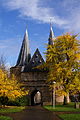
- The Koornmarktpoort: a city gate located near the river IJssel which probably dates from the 14th century. In the 15th century two squat towers were added at the outer corners.
- The Broederpoort: a rectangular city gate with four slender towers, originally from 1465, rebuilt in Renaissance style in 1615
- The Cellebroederspoort: a rectangular city gate, flanked by two heavy round towers, originally from 1465, rebuilt in 1617 in Renaissance style
- The Stedelijk Museum Kampen: located in the former town hall of Kampen, which dates from the late 14th century
- The Gotisch huis: built around 1500. This was the location of the Stedelijk Museum Kampen before it moved to its current location in the old town hall.
- The Nieuwe Toren: a tower with a carillon designed by Philips Vingboons and dating from 1648 to 1664
- The Church of St. Nicholas (Bovenkerk): a great Gothic basilica dating from the 14th and 15th centuries. The interior of the church houses an early-Renaissance choir screen (1552), a stone pulpit (circa 1500) and a monumental organ from 1670 to 1676.
- The Broederkerk: a 14th-century church which originally belonged to a Franciscan monastery
- The Buitenkerk: a 14th-century church
- The Burgwalkerk: a neoclassical 19th-century church
- A windmill called d'Olde Zwarver, built in 1842
- A monastery gate dating from 1165 called Linnenweverspoortje
- The city auditorium (Stadsgehoorzaal), dating from 1891
- An old tobacco factory, De Olifant, where cigars are still made with 19th-century equipment. De Olifant cigars are sold in the shop and guided tours are available.
Throughout the town of Kampen, there are colorful murals which are in fact old commercials for now-defunct business in Kampen. These murals, which include Art Nouveau influences, were made by local artists and are now referred to as "frescoes of the middle class". As a result of current municipal policy, wherever these murals are discovered under old plaster, they are restored to their former glory.
A number of better or lesser known people with a certain connection with Kampen is honoured with a commemorative stone bearing their name and a single-sentence characterization of their personality or achievements, incorporated into the pavement of the Oude Raadhuisplein (formerly Koeplein), the square in between the old town hall, the former Post Office and Nieuwe Toren.
Gallery
 Cellebroederspoort in Kampen
 Former synagogue in Kampen
 Former town hall
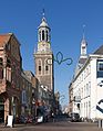 New Tower (Nieuwe Toren)
 Church: Bovenkerk
 Bridge (Kalverhekkenbrug) and church (Buitenkerk)
 Reformed church
![Protestant Theological University Kampen [Protestantse Theologische Universiteit vestiging Kampen]](//upload.wikimedia.org/wikipedia/commons/thumb/8/87/2007-04-23_14.14_Kampen%2C_theologische_universiteit.JPG/160px-2007-04-23_14.14_Kampen%2C_theologische_universiteit.JPG) Protestant Theological University Kampen
Protestant Theological University Kampen Windmill: d' Olde Zwarver
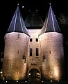 Towngate: Korenmarktpoort
 Bridge: Stadsbrug
 Ship at the IJsselkade
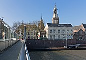 Office building of the ABN AMRO bank at the IJsselkade
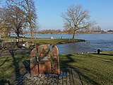 Liberation memorial at the De La Sablonairekade
![The new Anabranch called Reevediep [nl]](//upload.wikimedia.org/wikipedia/commons/thumb/7/72/Onderdijksewaard7.jpg/161px-Onderdijksewaard7.jpg) The new Anabranch called Reevediep
The new Anabranch called Reevediep The westside of the island of Kampen, with marches going into the Drontermeer


![Protestant Theological University Kampen [Protestantse Theologische Universiteit vestiging Kampen]](http://upload.wikimedia.org/wikipedia/commons/8/87/2007-04-23_14.14_Kampen%2C_theologische_universiteit.JPG)


![The new Anabranch called Reevediep [nl]](http://upload.wikimedia.org/wikipedia/commons/7/72/Onderdijksewaard7.jpg)

Festivals and events
An annual festival during the summer months is the Kamper ui(t) day. The name is derived from a series of folk tales in which the inhabitants of Kampen were portrayed as stupid. Another summer event is the Full Color Festival, which is organized annually. Every third Saturday of August, a comics event, called the Kamper Stripspektakel, is organized with over 100 booths.
Once every three years Sail Kampen takes place, a sailing spectacle with (old) sailing ships.
A weekend before Christmas Christmas in Oud Kampen is organized. There is street theater, where pieces of famous musicals are played, and mid-nineteenth-century characters are walking around the city.
Sports
Kampen is the home of football team Go Ahead Kampen and its rivals Dos Kampen, KHC Kampen, VV Kampen and IJVV.
Twin towns
Kampen is twinned with:
|
Transportation

The Kampen railway station opened in 1865 as terminus of the Kamperlijntje branch from Overijssel's capital city Zwolle. It is served by a non-stop diesel service on a single track. The line was renovation in summer 2017 to be electrified. From December 2017, Keolis Nederland takes over the line, after Nederlandse Spoorwegen had lost the line in a tendering process. There is an alternative railway connection with Zwolle via the Hanzelijn, which links Zwolle with Amsterdam via Dronten, Lelystad and Almere. It was inaugurated by Queen Beatrix in December 2012. Kampen Zuid railway station was built a few kilometers south of Kampen near the junction of the national roads N50 and N764, where a new residential development is planned. Somewhat confusingly there has been a Kampen Zuid railway station in existence before, between 1 October 1913 and 15 May 1934. This was the terminus of the Kampen–Hattem railway line, which connected with the Zwolle–Apeldoorn service via Wapenveld and Heerde. Regular passenger services on this line ceased in 1950. Other roads connecting the city include N760, N763, N765 and N307.
Education
Kampen has two theological universities: the Theological University of the Protestant Church in the Netherlands (PThU) and the theological college of the Reformed Church of the Netherlands (TUK).
Notable residents


The Arts
- Hendrick Avercamp (1585 – 1634 in Kampen) a painter of small winter landscapes
- Barent Avercamp (1612 in Kampen – 1679) a Dutch painter
- Jacob Eduard van Heemskerck van Beest (1828 in Kampen – 1894) a Dutch painter
- Coen Hissink (1878 in Kampen – 1942) a Dutch film actor of the silent era[8]
- Ida Gerhardt (1905 in Gorinchem – 1997) Dutch poet and classicist.[9]
- Gerard Hengeveld (1910 in Kampen – 2001) pianist, harpsichordist and composer.
- Sybren Polet (1924 in Kampen – 2015) a Dutch prose writer and poet
- Gait L. Berk, Dutch Wiki (1927 in Kampen – 2006) writer and film maker about boats and trees
- Henk van Ulsen (born 1927 in Kampen – 2009 ) actor[10]
- Klaas Jan Mulder, Dutch Wiki (1930 in Kampen - 2008) Dutch organist, pianist and conductor.
- Wim Ramaker, Dutch Wiki (1943 in Kampen – 1992) Dutch broadcaster, writer and poet
- Harry van der Kamp (born 1947 in Kampen) bass-baritone, bass-soloist and ensemble singer
Public thinking & Public Service

- Albert Pighius (ca. 1490 in Kampen - 1542) a Dutch Roman Catholic theologian, mathematician and astronomer.
- Jacob van Deventer (ca.1500/1505 in Kampen – 1575) a Dutch cartographer
- Andries Hudde (1608 in Kampen – 1663) landowner and colonial official of New Netherland
- François Adriaan van der Kemp (1752 in Kampen – 1829) a Dutch radical leaders of the Patriots
- Jan Willem de Winter (1761 in Kampen – 1812) a Dutch admiral of the Napoleonic Wars
- Pieter Hendrik van Zuylen van Nijevelt (1782 in Kampen – 1825) a Dutch count and baron and Army general
- Francina Broese Gunningh (1783 in Kampen - 1824) a Dutch soldier
- Jean-Pierre Cluysenaar (1811 in Kampen – 1880) a Belgian architect
- Hendrik Tonneboeijer (1814 in Kampen – 1837) a Dutch colonial officer in Dutch Gold Coast
- Lucien von Römer (1873 in Kampen - 1965), a Dutch physician, botanist and writer
- Jan Joseph Godfried, Baron van Voorst tot Voorst Jr. (1880 in Kampen – 1963) commander of the Dutch armed forces during WWII and strategist
- Haicke Janssen (1885 in Kampen – 1915) a sailor and World War I spy for the German naval intelligence; executed in the Tower of London
- Klaas Schilder (1890 in Kampen – 1952) Reformed theologian and professor in the Reformed Churches in the Netherlands
- Adriaan Schuurman, Dutch Wiki (1904 in Kampen – 1998) organist and Protestant church musician
- Wiert Berghuis, Dutch Wiki (1911 in Kampen - 1989) Mayor of Kampen 1952–1970, chairman of the Anti-Revolutionary Party
- Dr. Willem Johan Kolff (1911 in Leiden – 2009) physician at the former municipal hospital, pioneer of haemodialysis.[11]
- G. A. den Hartogh (born 1943 in Kampen) a Dutch moral, legal and political philosopher
Sport

- Benjamin Leussen (1876 in Kampen - 1924) chess player
- Petra van Staveren (born 1966 in Kampen), swimmer, golden medallist at the 1984 Summer Olympics
- Jaap Stam (born 1972 in Kampen), retired football player with 415 club caps
- Reinder Nummerdor (born 1976) a Dutch volleyball player, competed in five consecutive Summer Olympics
- Robert de Wilde (born 1977 in Kampen), BMX World Champion, competed at the 2008 Summer Olympics
- and
- Aalt Mondria (born 1957 in Kampen - 2011) a Dutch criminal and serial killer
References
- "Burgemeester drs. mr. B. Koelewijn" (in Dutch). Gemeente Kampen. Archived from the original on 28 July 2014. Retrieved 30 March 2014.
- "Kerncijfers wijken en buurten 2020" [Key figures for neighbourhoods 2020]. StatLine (in Dutch). CBS. 24 July 2020. Retrieved 19 September 2020.
- "Postcodetool for 8261DD". Actueel Hoogtebestand Nederland (in Dutch). Het Waterschapshuis. Archived from the original on 21 September 2013. Retrieved 30 March 2014.
- "Bevolkingsontwikkeling; regio per maand" [Population growth; regions per month]. CBS Statline (in Dutch). CBS. 1 January 2019. Retrieved 1 January 2019.
- Kampen in fragmenten, drs. René van Mierlo, 1990, Kok.
- Milevsky, Moshe A. (April 13, 2015). King William's Tontine: Why the Retirement Annuity of the Future Should Resemble its Past. Cambridge University Press. ISBN 9781107076129 – via Google Books.
- "Partnersteden | Gemeente Kampen". www.kampen.nl.
- IMDb Database retrieved 23 August 2019
- "Ida Gerhardt - Canon van Kampen - regiocanons.nl". regiocanons.nl.
- IMDb Database retrieved 23 August 2019
- "Dokter Kolff - Canon van Kampen - regiocanons.nl". regiocanons.nl.
External links
 Media related to Kampen, Netherlands at Wikimedia Commons
- Official website
- A view on the old city of Kampen
Places adjacent to Kampen, Overijssel | ||||||||||||||||
|---|---|---|---|---|---|---|---|---|---|---|---|---|---|---|---|---|
| ||||||||||||||||
Members of the Hanseatic League by quarter | |||||
|---|---|---|---|---|---|
| |||||
| Wendish |
| 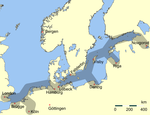  | |||
| Saxon | |||||
| Baltic | |||||
| Westphalian | |||||
| Kontore |
| ||||
| Other cities | |||||
Overijssel province | ||
|---|---|---|
| Municipalities |  | |
| Regions |
| |
| ||
На других языках
[de] Kampen (Niederlande)
Kampen ( anhören?/i) ist eine Gemeinde und ehemalige Hansestadt in der niederländischen Provinz Overijssel mit einer Fläche von 161,84 km² und 54.780 Einwohnern.- [en] Kampen, Overijssel
[ru] Кампен (Нидерланды)
Кампен (нидерл. Kampen) — город и община в Нидерландах в провинции Оверэйссел.Другой контент может иметь иную лицензию. Перед использованием материалов сайта WikiSort.org внимательно изучите правила лицензирования конкретных элементов наполнения сайта.
WikiSort.org - проект по пересортировке и дополнению контента Википедии