world.wikisort.org - Japan
Nantan (南丹市, Nantan-shi) is a city located in Kyoto Prefecture, Japan. As of 1 May 2022[update], the city had an estimated population of 30,744 in 14406 households and a population density of 50 persons per km².[1] The total area of the city is 616.40 square kilometres (237.99 sq mi).
Nantan
南丹市 | |
|---|---|
City | |
 Nantan City hall | |
 Flag  Emblem | |
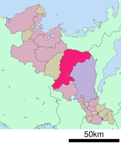 Location of Nantan in Kyoto Prefecture | |
 Nantan Location in Japan | |
| Coordinates: 35°6′N 135°28′E | |
| Country | Japan |
| Region | Kansai |
| Prefecture | Kyoto |
| Government | |
| • Mayor | Yohei Nishimura (since April 2014) |
| Area | |
| • Total | 616.40 km2 (237.99 sq mi) |
| Population (May 1, 2022) | |
| • Total | 30,744 |
| • Density | 50/km2 (130/sq mi) |
| Time zone | UTC+09:00 (JST) |
| City hall address | 47 Kozakura, Sonobe-cho, Nantan-shi, Kyoto-fu 622-8651 |
| Climate | Cfa |
| Website | Official website |
| Symbols | |
| Bird | Blue-and-white flycatcher |
| Flower | Cherry blossom |
| Tree | Fagus crenata |

Geography
Nantan is located in the southern part of the Tamba region in central Kyoto Prefecture.
Neighbouring municipalities
Kyoto Prefecture
Fukui Prefecture
Shiga Prefecture
Osaka Prefecture
Hyōgo Prefecture
Climate
Nantan has a Humid climate (Köppen Cfa) characterized by warm, wet summers and cold winters with heavy snowfall. The average annual temperature in Nantan is 13.0 °C (55.4 °F). The average annual rainfall is 1,808.3 mm (71.19 in) with July as the wettest month. The temperatures are highest on average in August, at around 25.2 °C (77.4 °F), and lowest in January, at around 1.7 °C (35.1 °F).[2] Its record high is 36.7 °C (98.1 °F), reached on 21 August 2020, and its record low is −11.8 °C (10.8 °F), reached on 28 February 1981.[3]
| Climate data for Nantan (1991−2020 normals, extremes 1978−present) | |||||||||||||
|---|---|---|---|---|---|---|---|---|---|---|---|---|---|
| Month | Jan | Feb | Mar | Apr | May | Jun | Jul | Aug | Sep | Oct | Nov | Dec | Year |
| Record high °C (°F) | 16.9 (62.4) |
21.1 (70.0) |
24.4 (75.9) |
29.8 (85.6) |
31.9 (89.4) |
33.6 (92.5) |
36.6 (97.9) |
36.7 (98.1) |
36.0 (96.8) |
30.8 (87.4) |
24.5 (76.1) |
21.8 (71.2) |
36.7 (98.1) |
| Average high °C (°F) | 6.2 (43.2) |
7.0 (44.6) |
11.5 (52.7) |
17.8 (64.0) |
22.9 (73.2) |
25.8 (78.4) |
29.7 (85.5) |
31.2 (88.2) |
26.6 (79.9) |
20.9 (69.6) |
15.2 (59.4) |
9.2 (48.6) |
18.7 (65.6) |
| Daily mean °C (°F) | 1.7 (35.1) |
2.1 (35.8) |
5.6 (42.1) |
11.1 (52.0) |
16.2 (61.2) |
20.3 (68.5) |
24.3 (75.7) |
25.2 (77.4) |
21.2 (70.2) |
15.1 (59.2) |
9.4 (48.9) |
4.2 (39.6) |
13.0 (55.5) |
| Average low °C (°F) | −1.3 (29.7) |
−1.5 (29.3) |
0.7 (33.3) |
5.0 (41.0) |
10.4 (50.7) |
15.8 (60.4) |
20.5 (68.9) |
21.0 (69.8) |
17.1 (62.8) |
11.0 (51.8) |
5.2 (41.4) |
0.7 (33.3) |
8.7 (47.7) |
| Record low °C (°F) | −11.2 (11.8) |
−11.8 (10.8) |
−8.7 (16.3) |
−3.3 (26.1) |
1.3 (34.3) |
4.2 (39.6) |
11.9 (53.4) |
12.8 (55.0) |
6.7 (44.1) |
1.3 (34.3) |
−3.7 (25.3) |
−6.6 (20.1) |
−11.8 (10.8) |
| Average precipitation mm (inches) | 140.3 (5.52) |
128.5 (5.06) |
139.5 (5.49) |
121.9 (4.80) |
149.7 (5.89) |
177.1 (6.97) |
205.1 (8.07) |
148.8 (5.86) |
202.3 (7.96) |
161.7 (6.37) |
107.3 (4.22) |
126.3 (4.97) |
1,808.3 (71.19) |
| Average snowfall cm (inches) | 73 (29) |
73 (29) |
9 (3.5) |
0 (0) |
0 (0) |
0 (0) |
0 (0) |
0 (0) |
0 (0) |
0 (0) |
0 (0) |
26 (10) |
179 (70) |
| Average precipitation days (≥ 1.0 mm) | 17.9 | 16.2 | 15.4 | 11.9 | 11.3 | 12.6 | 12.7 | 9.2 | 12.0 | 11.4 | 12.3 | 16.1 | 159 |
| Average snowy days (≥ 3 cm) | 6.9 | 6.6 | 1.0 | 0 | 0 | 0 | 0 | 0 | 0 | 0 | 0 | 2.2 | 16.7 |
| Mean monthly sunshine hours | 74.1 | 85.3 | 124.1 | 168.2 | 184.3 | 129.9 | 136.9 | 177.1 | 126.5 | 128.5 | 109.5 | 88.0 | 1,533.8 |
| Source: Japan Meteorological Agency[3][2] | |||||||||||||
| Climate data for Sonobe, Nantan (2002−2020 normals, extremes 2002−present) | |||||||||||||
|---|---|---|---|---|---|---|---|---|---|---|---|---|---|
| Month | Jan | Feb | Mar | Apr | May | Jun | Jul | Aug | Sep | Oct | Nov | Dec | Year |
| Record high °C (°F) | 17.3 (63.1) |
21.5 (70.7) |
24.6 (76.3) |
31.1 (88.0) |
33.0 (91.4) |
35.6 (96.1) |
38.0 (100.4) |
38.2 (100.8) |
37.0 (98.6) |
31.5 (88.7) |
25.2 (77.4) |
22.5 (72.5) |
38.2 (100.8) |
| Average high °C (°F) | 7.7 (45.9) |
9.0 (48.2) |
13.0 (55.4) |
19.1 (66.4) |
24.4 (75.9) |
27.4 (81.3) |
31.0 (87.8) |
32.8 (91.0) |
28.3 (82.9) |
22.2 (72.0) |
16.3 (61.3) |
10.3 (50.5) |
20.1 (68.2) |
| Daily mean °C (°F) | 2.2 (36.0) |
3.3 (37.9) |
6.5 (43.7) |
12.0 (53.6) |
17.5 (63.5) |
21.6 (70.9) |
25.4 (77.7) |
26.4 (79.5) |
22.4 (72.3) |
15.9 (60.6) |
9.7 (49.5) |
4.4 (39.9) |
13.9 (57.1) |
| Average low °C (°F) | −2.0 (28.4) |
−1.4 (29.5) |
0.6 (33.1) |
5.2 (41.4) |
11.3 (52.3) |
16.9 (62.4) |
21.5 (70.7) |
22.0 (71.6) |
17.9 (64.2) |
11.1 (52.0) |
4.6 (40.3) |
−0.1 (31.8) |
9.0 (48.1) |
| Record low °C (°F) | −10.8 (12.6) |
−10.5 (13.1) |
−5.5 (22.1) |
−3.2 (26.2) |
1.6 (34.9) |
8.1 (46.6) |
15.0 (59.0) |
13.9 (57.0) |
9.1 (48.4) |
0.8 (33.4) |
−3.9 (25.0) |
−12.8 (9.0) |
−12.8 (9.0) |
| Average precipitation mm (inches) | 60.8 (2.39) |
78.4 (3.09) |
115.2 (4.54) |
117.4 (4.62) |
129.8 (5.11) |
166.5 (6.56) |
205.3 (8.08) |
159.5 (6.28) |
200.3 (7.89) |
162.9 (6.41) |
72.9 (2.87) |
77.6 (3.06) |
1,570.2 (61.82) |
| Average precipitation days (≥ 1.0 mm) | 10.2 | 11.4 | 11.6 | 10.8 | 9.8 | 12.0 | 12.6 | 8.9 | 10.5 | 9.1 | 8.2 | 9.7 | 124.8 |
| Mean monthly sunshine hours | 103.4 | 107.4 | 151.4 | 179.6 | 191.9 | 140.6 | 142.7 | 193.4 | 147.3 | 142.1 | 117.8 | 109.4 | 1,729.6 |
| Source: Japan Meteorological Agency[4][5] | |||||||||||||
Demographics
Per Japanese census data,[6] the population of Nantan has declined slightly in recent decades.
| Year | Pop. | ±% |
|---|---|---|
| 1960 | 45,262 | — |
| 1965 | 41,853 | −7.5% |
| 1970 | 39,318 | −6.1% |
| 1975 | 38,409 | −2.3% |
| 1980 | 38,215 | −0.5% |
| 1985 | 37,709 | −1.3% |
| 1990 | 36,693 | −2.7% |
| 1995 | 37,841 | +3.1% |
| 2000 | 37,617 | −0.6% |
| 2005 | 36,736 | −2.3% |
| 2010 | 35,214 | −4.1% |
| 2015 | 33,145 | −5.9% |
| 2020 | 31,629 | −4.6% |
| Nantan population statistics[6] | ||
History
The area of the modern town of Nantan was within ancient Tanba Province, and may have been the site of the provincial capital in the Nara period. During the Edo Period, Sonobe Domain was located within its borders. The town of Sonobe was established with the creation of the modern municipalities system on April 1, 1889. Sonobe merged with the neighboring towns of Hiyoshi, and Yagi (all from Funai District), and the town of Miyama (from Kitakuwada District) to form the city of Nantan on January 1, 2006.
Government
Nantan has a mayor-council form of government with a directly elected mayor and a unicameral town council of 22 members. Nantan, together with the town of Kyōtamba contributes one member to the Kyoto Prefectural Assembly. In terms of national politics, the city is part of Kyoto 4th district of the lower house of the Diet of Japan.
Economy
Nantan has an economy based on regional commerce, agriculture and forestry. The main products include mizuna and other "Kyoto vegetables".
Education
Colleges and universities
- Bukkyo University, Sonobe campus
- College of Medical Technology Meiji University of Oriental Medicine
- Kyoto College of Medical Technology
- Kyoto University of Arts and Crafts
- Meiji University of Integrative Medicine
Primary and secondary schools
Nantan has seven public elementary schools and five public middle schools operated by the city government and three public high schools operated by the Kyoto Prefectural Department of Education. There is also one private middle school and one private high school. The prefecture also operates one special education school for the handicapped.
Transportation
Railway
![]() JR West – San'in Main Line / [[Sagano Line)
JR West – San'in Main Line / [[Sagano Line)
Highway
 Kyoto Jūkan Expressway
 National Route 9
 National Route 162
 National Route 372
 National Route 477
Sister city relations
 Manila, Philippines[7]
 Clutha District, New Zealand[7]
Localattractions
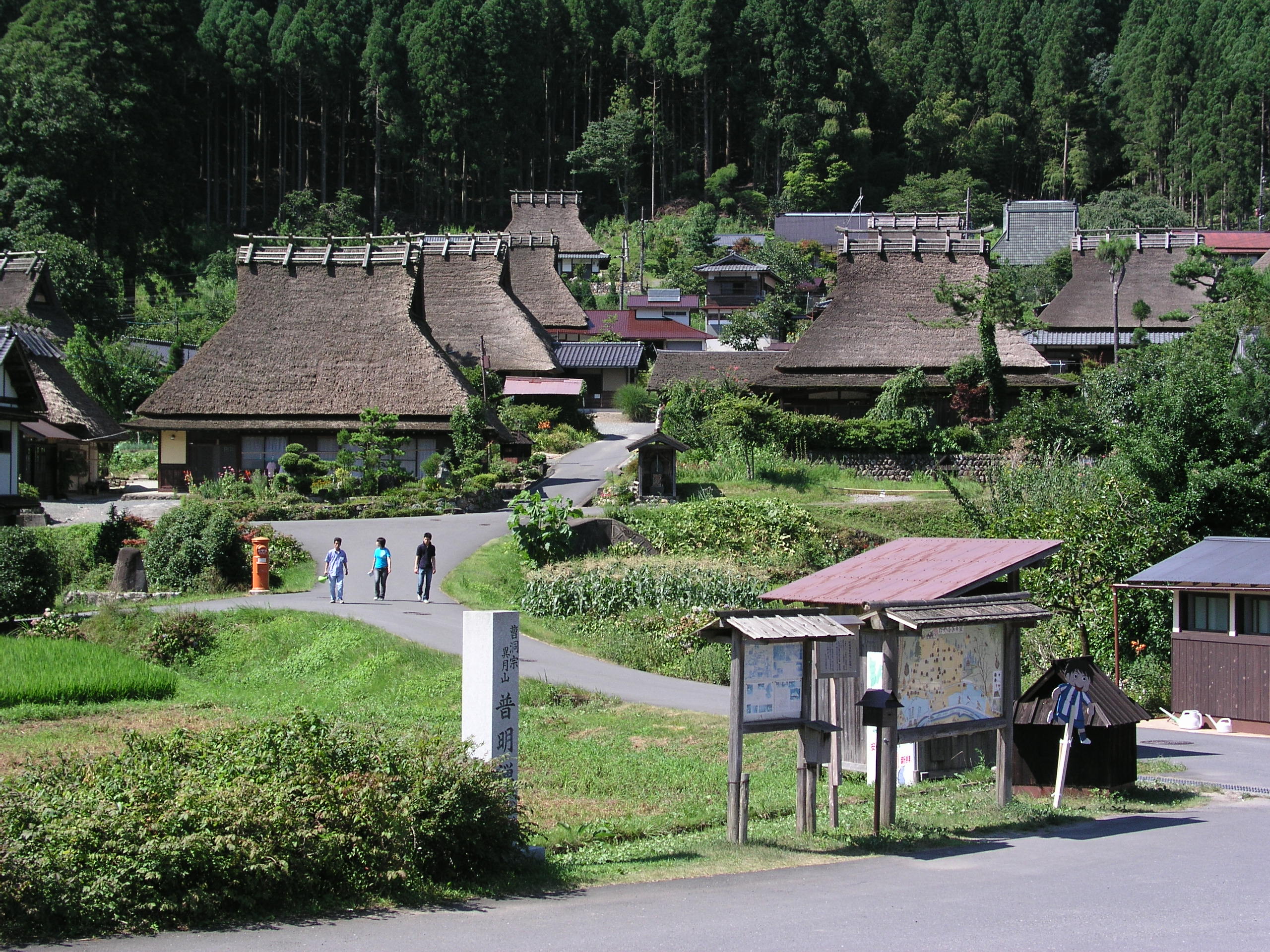
Sights include the Rurikei Prefectural Natural Park and Miyama Kayabuki no sato "Thatched farmhouses village".
Noted people from Nantan
- Shigeru Miyamoto – video game designer and creator of Mario and The Legend of Zelda
- Bonnie Pink – singer-songwriter
- Makoto Fujita – actor
- Hiromu Nonaka – politician
- Yoshimi Tanaka – politician
- Yasuhiro Nakagawa – politician
References
- "Nantan city official statistics" (in Japanese). Japan.
- 気象庁 / 平年値(年・月ごとの値). JMA. Retrieved March 26, 2022.
- 観測史上1~10位の値(年間を通じての値). JMA. Retrieved March 26, 2022.
- 観測史上1~10位の値(年間を通じての値). JMA. Retrieved March 29, 2022.
- 気象庁 / 平年値(年・月ごとの値). JMA. Retrieved March 29, 2022.
- Nantan population statistics
- "Sister cities, towns and villages of Kyoto Prefecture". Kyoto Prefecture Website. Retrieved 5 February 2015.
External links
 Media related to Nantan, Kyoto at Wikimedia Commons
- Nantan City official website (in Japanese) (some English)
This Kyoto Prefecture location article is a stub. You can help Wikipedia by expanding it. |
На других языках
[de] Nantan
Nantan (jap. .mw-parser-output .Hani{font-size:110%}南丹市, -shi) ist eine japanische Stadt im Norden der Präfektur Kyōto.- [en] Nantan, Kyoto
[ru] Нантан
Нантан (яп. 南丹市 Нантан-си) — город в Японии, находящийся в префектуре Киото. Площадь города составляет 616,40 км²[1], население — 31 650 человек (1 октября 2020)[2], плотность населения — 51,35 чел./км².Другой контент может иметь иную лицензию. Перед использованием материалов сайта WikiSort.org внимательно изучите правила лицензирования конкретных элементов наполнения сайта.
WikiSort.org - проект по пересортировке и дополнению контента Википедии