world.wikisort.org - Japan
Nose (能勢町, Nose-chō) (Japanese pronunciation: [nose]) is a town situated in Toyono District, Osaka Prefecture, Japan.
Nose
能勢町 | |
|---|---|
Town | |
 Flag | |
 Location of Nose in Osaka Prefecture | |
 Nose Location in Japan | |
| Coordinates: 34°58′N 135°25′E | |
| Country | Japan |
| Region | Kansai Kinki |
| Prefecture | Osaka Prefecture |
| District | Toyono |
| Government | |
| • Mayor | Kazuhiro Naka |
| Area | |
| • Total | 98.68 km2 (38.10 sq mi) |
| Population (October 1, 2016) | |
| • Total | 9,971 |
| • Density | 100/km2 (260/sq mi) |
| Time zone | UTC+09:00 (JST) |
| City hall address | 28 Shukuno, Nose-chō, Toyono-gun, Osaka-fu 563-0392 |
| Climate | Cfa |
| Website | www |
As of October 2016, the town has an estimated population of 9,971 and a density of 100 persons per km² (262/sq mi). The total area is 98.68 km² (38.1 sq mi).
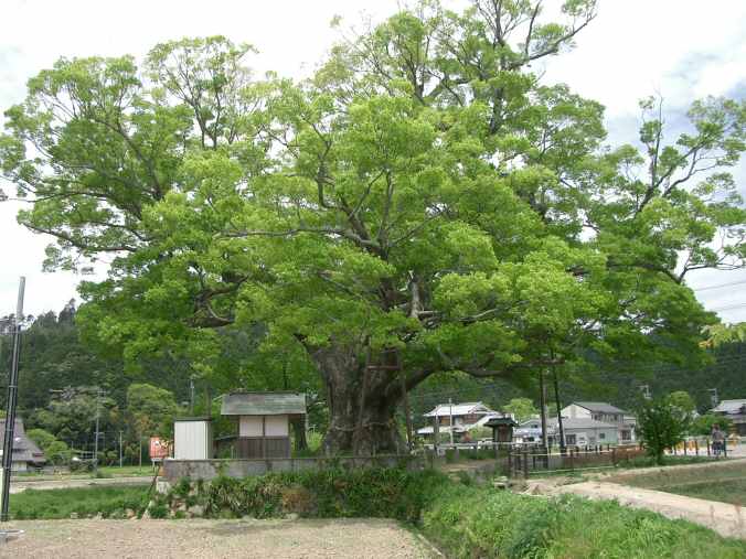
Nose is noted for the "Noma Keyaki", a 1,000-year-old Keyaki tree, 25 m tall (82 ft), 11.95 m (39.2 ft) trunk circumference.[1]
History
People lived in Nose area in the Jomon Period, (ca. 10,000 BCE – ca. 300 BCE). Nose's ancient name is Kusaka Village. It is mentioned in the Nihon Shoki, completed in 720 CE.[2]
In 1837, there was an important peasant revolt in Nose, in the context of the Tenpō famine (1833-1839), some months after Ōshio Heihachirō’s riot.[3]
Geography
Nose is surrounded in all directions, including Mount Miyama (791m)[4] and Mount Kenpi (784m). Besides, many streams, Yamabe, Hitokuraohroji, Noma and Tajiri Rivers flow in the Inagawa River basin, and Katsura River also flow in the town.
Climate
Nose has a Humid subtropical climate (Köppen Cfa) characterized by warm summers and cool winters with light to no snowfall. The average annual temperature in Nose is 13.8 °C (56.8 °F). The average annual rainfall is 1,483.1 mm (58.39 in) with July as the wettest month. The temperatures are highest on average in August, at around 25.9 °C (78.6 °F), and lowest in January, at around 2.4 °C (36.3 °F).[5]
| Climate data for Nose (1991−2020 normals, extremes 1977−present) | |||||||||||||
|---|---|---|---|---|---|---|---|---|---|---|---|---|---|
| Month | Jan | Feb | Mar | Apr | May | Jun | Jul | Aug | Sep | Oct | Nov | Dec | Year |
| Record high °C (°F) | 16.3 (61.3) |
19.8 (67.6) |
22.6 (72.7) |
28.4 (83.1) |
32.0 (89.6) |
34.4 (93.9) |
37.3 (99.1) |
37.4 (99.3) |
35.1 (95.2) |
30.4 (86.7) |
25.5 (77.9) |
20.3 (68.5) |
37.4 (99.3) |
| Average high °C (°F) | 7.4 (45.3) |
8.3 (46.9) |
12.2 (54.0) |
18.1 (64.6) |
22.9 (73.2) |
25.8 (78.4) |
29.4 (84.9) |
31.2 (88.2) |
27.2 (81.0) |
21.5 (70.7) |
15.7 (60.3) |
10.0 (50.0) |
19.1 (66.5) |
| Daily mean °C (°F) | 2.4 (36.3) |
3.1 (37.6) |
6.5 (43.7) |
12.0 (53.6) |
17.1 (62.8) |
21.0 (69.8) |
24.8 (76.6) |
25.9 (78.6) |
22.0 (71.6) |
16.0 (60.8) |
9.9 (49.8) |
4.6 (40.3) |
13.8 (56.8) |
| Average low °C (°F) | −1.9 (28.6) |
−1.5 (29.3) |
1.0 (33.8) |
5.9 (42.6) |
11.5 (52.7) |
16.7 (62.1) |
21.0 (69.8) |
21.7 (71.1) |
17.8 (64.0) |
11.3 (52.3) |
4.7 (40.5) |
0.0 (32.0) |
9.0 (48.2) |
| Record low °C (°F) | −8.2 (17.2) |
−10.8 (12.6) |
−6.9 (19.6) |
−3.5 (25.7) |
−0.2 (31.6) |
6.1 (43.0) |
12.3 (54.1) |
13.1 (55.6) |
6.7 (44.1) |
−0.1 (31.8) |
−3.7 (25.3) |
−7.4 (18.7) |
−10.8 (12.6) |
| Average precipitation mm (inches) | 49.9 (1.96) |
61.5 (2.42) |
100.6 (3.96) |
111.0 (4.37) |
145.7 (5.74) |
181.2 (7.13) |
213.0 (8.39) |
154.5 (6.08) |
192.4 (7.57) |
142.8 (5.62) |
72.8 (2.87) |
57.8 (2.28) |
1,483.1 (58.39) |
| Average precipitation days (≥ 1.0 mm) | 6.5 | 7.6 | 9.9 | 9.9 | 10.2 | 11.5 | 11.8 | 9.0 | 10.4 | 9.0 | 6.4 | 7.1 | 109.3 |
| Mean monthly sunshine hours | 113.4 | 113.0 | 147.6 | 179.2 | 189.9 | 132.5 | 152.2 | 195.7 | 150.0 | 153.8 | 134.5 | 122.6 | 1,784.5 |
| Source: Japan Meteorological Agency[6][5] | |||||||||||||
Demographics
Per Japanese census data, the population of Nose in 2020 is 9,079 people.[7] Nose has been conducting censuses since 1920.
| Year | Pop. | ±% |
|---|---|---|
| 1920 | 9,796 | — |
| 1925 | 9,914 | +1.2% |
| 1930 | 10,011 | +1.0% |
| 1935 | 9,853 | −1.6% |
| 1940 | 10,034 | +1.8% |
| 1945 | 12,388 | +23.5% |
| 1950 | 12,057 | −2.7% |
| 1955 | 11,426 | −5.2% |
| 1960 | 10,467 | −8.4% |
| 1965 | 9,906 | −5.4% |
| 1970 | 9,521 | −3.9% |
| 1975 | 9,749 | +2.4% |
| 1980 | 10,024 | +2.8% |
| 1985 | 10,389 | +3.6% |
| 1990 | 10,850 | +4.4% |
| 1995 | 13,876 | +27.9% |
| 2000 | 14,186 | +2.2% |
| 2005 | 12,897 | −9.1% |
| 2010 | 11,659 | −9.6% |
| 2015 | 10,256 | −12.0% |
| 2020 | 9,079 | −11.5% |
| Nose population statistics[7] | ||
Transportation
Rails
No train stations locate at Nose. The nearest station is Yamashita Station, Kawanishi, Hyōgo.
Roads
- National highway
- National Route 173
- National Route 477
- Prefectural road
- Osaka Prefectural Route 4
- Osaka Prefectural Route 54
References
- Osaka Toyono County: Noma Keyaki (in Japanese; google translation)
- "Sightseeing Spots | Nose Town Tourism & Local Products". www.town-of-nose.jp. Retrieved 2020-05-02.
- J. Newmark, Yamadaya Daisuke’s 1837 Nose Movement, Early Modern Japan: An Interdisciplinary Journal v. 22 (2014), p. 8-28
- "Nose Town Tourism & Local Products". www.town-of-nose.jp. Retrieved 2020-05-02.
- 気象庁 / 平年値(年・月ごとの値). JMA. Retrieved April 12, 2022.
- 観測史上1~10位の値(年間を通じての値). JMA. Retrieved April 12, 2022.
- Nose population statistics
External links
 Media related to Nose, Osaka at Wikimedia Commons
- Nose official website (in Japanese)
- Nose Town Tourism & Local Products
Osaka (capital) | ||||
| Osaka |
| |||
| Sakai |
| |||
| Core cities | ||||
| Special cities | ||||
| Cities |
| |||
| Districts | ||||
List of mergers in Osaka Prefecture; Note: ☆ - Cities to become core cities | ||||
Authority control | |
|---|---|
| General | |
| National libraries | |
This Osaka Prefecture location article is a stub. You can help Wikipedia by expanding it. |
На других языках
- [en] Nose, Osaka
[es] Nose (Osaka)
Nose (能勢町, Nose-chō?) es un pueblo localizado en la prefectura de Osaka, Japón. En agosto de 2019 tenía una población estimada de 9.266 habitantes y una densidad de población de 93,8 personas por km². Su área total es de 98,75 km².[ru] Носе
Носе (яп. 能勢町 Носэ-тё:) — посёлок в Японии, находящийся в уезде Тоёно префектуры Осака. Площадь посёлка составляет 98,68 км²[1], население — 10 595 человек (1 августа 2014)[2], плотность населения — 107,37 чел./км².Другой контент может иметь иную лицензию. Перед использованием материалов сайта WikiSort.org внимательно изучите правила лицензирования конкретных элементов наполнения сайта.
WikiSort.org - проект по пересортировке и дополнению контента Википедии